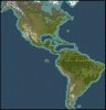
Here`s the map of the twin american continents.
Originally created by Knopfdruckoffizier for Civilization IV.
All I did was extend the map a little to the north and to the west, then some fine tuning with rivers, coastline and a little with other aspects.
I always thought that the north America was missing a hand in this original creation, so I drew the Alaska (well, most of it), some of the northern Canada and the southern Greenland there.
The map can be found at the downloads section.