D&D mod: tjedge1-Mystara

Would you be interested in a D&D mod?

  • Yes!

    Votes: 186 84.5%
  • No way!

    Votes: 3 1.4%
  • Not really sure.

    Votes: 13 5.9%
  • What is D&D?

    Votes: 18 8.2%

  • Total voters
    220
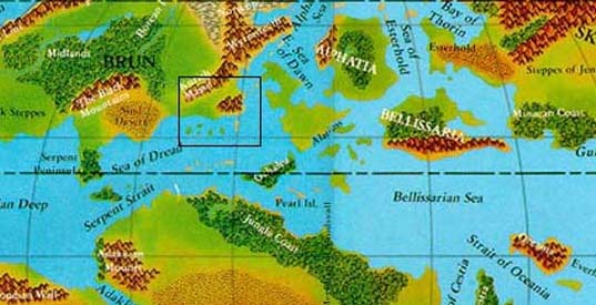
Here is a little more what I was needing for the scenario map. You don't have to go so far past the Savage Coast, or as far south as the map shows, but I would like the rest of the map in. I just posted a little extra on the West and South in case you had room on the map. I like your maps so far, and I think I need to find out what this map utitlity you are using. Could be real handy in my later mods.
:hmm: 
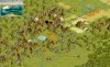
Let me crop it again and see if it fits. Maybe it's too long to show.
:suicide: :wallbash: :p :rolleyes: 
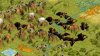
Maybe if I spelled it right, I wouldn't have had to upload it twice. Well here is what I need.

wowmodmap1.jpg


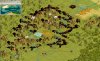
EDIT: You know now that I think about it. Maybe not so far east into Skothar and so far south as the Izonda coast. Let me know if you have any questions.
 
How is the mod going? For Christmas I think I'm (finally) getting one of those animator programs. And I want to help in every way I can, although I don't know much about D&D.
 
So far it's going slow. Not as slow as I thought it might. Once I finish typing in all the info on the editor then I will have to type up the text files and figure out what graphix will have to be included for terrain, leaderheads, buildings, civlopedia and so on. A ways to go, but I will stay on it and try to finish as soon after the New Year as I can. Partly because my wife wants to play it and partly because I am drooling over my notes for a Wheel of Time mod. Having trouble keeping it out of my head since I bought the 10th book in that series. What a story. Nobody tell me what happens, I'm only half way through it. Now back to the mod.
 
I have a request that will help me out a lot. I need city lists of the following nations and wondered if anyone who has all or some of the gazetteers would be able to compile this for me and post it here with a text file or just straight onto a post. That would be very useful. I need about 50 to 75 cities. If there isn't that many, which is the case for most of these, then I will except tribe names, which will have to be done for some anyway, and names of major landmarks as long as they sound like they fit.

Alfheim
Alphatia (not including Isle of Dawn)
Artruaghin Clans
Darokin Republic
Ethengar Khanates
Five Shires
Principalities of Glantri
Heldann Freeholds
Hule
Ieriendi
Minrothad Guilds
Norwold
Ostland
Rockhome
Savage Coast City States
Sind
Soderfjord Jarldoms
Thar of the Broken Lands
Isle of Dawn
Thyatis (not including Isle of Dawn)
Traladara/Karamiekos
Vestland
Wendar
Yavdlom
Emerites of Ylaruam

If I missed any well known civs just let me know and I'll determine if they'll fit. There are several more civs than this planned, but I don't need their city lists as I already did them, these are the ones I haven't that have information that is available.

Any volounteers?
 
I'm afraid that's one of the only things I can't help you with, but if I ever get a unit animator and can start making good animations than I'll make up as many units as I can. It seems the Video Game Mod has died. What unit would be the easiest to make, like that Triceratops Rider would be lower down on a list because it sounds hard. I can't wait to see how frustrating, I mean fun, unit animations are. ;)
 
I think LouLong was working on a Triceratops Rider. He hasn't mentioned it to me in a while so I'm not sure if he's still going to do it. My lack of color pics might have changed his mind. I'm not sure what would be easiest.

I do need a special unit for the Red Steel Great Wonder. Something with a red sword and armor. He'll be one of the toughest units in the game. The reason I will use a wonder to produce them. Something like a knight without a horse. His armor would have to be a rusty red color, and his sword as well.

An armored Minotaur would be cool. Could use the Beastman that embryodead made and just put some Pikeman armor on him.

The thread in my sig has some complex ones and I've had little feed back on those. I have had some though ;).
 
I think I can provide you with some city names. The Ierendi and Glantri Gazetteers are right next to my computer, so I'll work on those first, though browsing through the Glantri Gazetteer, I don't see much with regards to city names.

Maybe I should try to find my Poor Wizard's Almanac instead :)
 
Actually the names of the principalities and the fortress and castles or camps or outposts will do also, since they are where many of Glantri's people live and work. You can include the ones that wre ruined in the event that messed up theri southern border. Something about an explosion and/or a meteor or something. I'll have to read up when I do the Wrath scenario since my memory seems to be a little vague there.

BTW: I was wondering when the Conquests version of DyP is coming out. My dad and I play that online a bunch. It's the only non-fantasy or ancient time mod I play.
 
I am really looking forward to this mod tjedge1 so I thought I'd give you some help:
Here are the city lists for Karameikos, Ylaruam,
Alfheim and Rockhome (see the attachment). I took the lists from the original gazeteers. I have all of the gazeteers, so I'll try and give and get any other names you need next week - when I have more time :)

If you need any other information - just ask....
 
Crap I just realized you wanted 50 -75 names for each nation
Oh well here is Karameikos - Note I included names of Forests, rivers as well as the last names of ministers - I believe there are 56 names. Is the format ok?
 
That is fine with me. I only wanted that many in case someone who plays that civ actually builds out of their normal area and for the random map game. That's great as long as they sound like they fit. If not no worries as I can adjust anything that doesn't when I type them into the editor. :thanx:
 
ok, i'll this shot as map basis.

i'll try to make u a sketch soon.

As for the utility, it's handy to have a basic layer in civ editor.

A size 256 map implies a grid with 65536 "hex", so painting it one by one just for having the basic skeleton of the map is a pain. imagine, even if u take 2 seconds to paint one grid square, it means that it takes u 36 hours (grosso modo)

For my test map, painting over an image takes me about 2-3 hours, and generating the map takes about 2-3 seconds (the time for clicking everywhere needed with the mouse :-) )

Now, making the skeleton map a true map is another part of the job. Correct town placement, ... , u easily take one ahour for an area (mainly because that's my first map, and i'll try to be as precise as possible - without that, of course, it's a faster process)

After there is the graphic flavour, by using LM landscapes. It's an important point, because without that, the map will seriously lack all the riches it has normally.

I'll make u Thar today. This area will be intresting and raising special problems. How to handle the fact that Thar population lives underground !! lol ! Because it's one of the reason for Thar territory being so hard to attack.

N.b. there is also underground life under the great waste if i remember well.

Perhaps this can be simulated with a special unit like isengard tower. i don't know.

http://forums.civfanatics.com/showthread.php?s=&threadid=68659

c u later
 
This wasn't as hard as I thought. Once I started looking for names of Forts and Castles, the names just started flooding me.

86 names in this list, the last eight could be cut, as they are names of Rivers, Valleys, Mountain Ranges and such. But the others are (in order of appearance in the list)
  • Cities (only one really, Glantri City)
  • Principalities (10 of those)
  • Villages (21)
  • Castles (10 of those)
  • Forts and minor Castles (35)
  • Historical (Only one, Braejr, original name for Glantri City)
  • Topographic (8)
For coordination purposes: I'll try Ierendi next. And after that I can do the Minothrad Guilds and Darokin (just found those Gazetteers too :) ).


As for DYP release date, we're working on it at the moment, but it's too early to say anything yet. Hopefully our testers will get to test the first 'beta' next week. I'd like to hear some more about your online bouts of DYP. We have never really heard about how the mod plays out in multiplayer, so please pass on any experiences you have (but lets keep them in the DYP thread - don't want to spoil this, my new past-time paradise) ;)

Edit: Oh bugger - never preview a reply when you have attached a file. Now I can't re-attach it. Ill link to it instead.

Principalities of Glantri City List
 
hi

here is the surface area above underground kingdom of thar. Nice place to live, huh.

Corunglain is on the south border.

Well, as for the map, it's like Sind, it's not real good i think.

I lack 3 elements : badlands (pollution instead) ; broken land (i use craters) and rocky desert ( i use LM hills => Chasm mod , which is not bad, but too green).
Without that, well we still can put mountains everywhere, but Thar kingdom is not Rockhome.
 

Attachments

  • mystara1-thar800600.jpg
    mystara1-thar800600.jpg
    45.3 KB · Views: 285
ah, i'm rather happy. Ok, it's certainly not what you we're expecting (or asking), but keep in mind i'm still toying with the editor and searching way to solve some graphic prob.

This map, based on the same sketch as presented before (ac 1011 josuah almanach basis), is a 60 x 60.

For the bandwith sake of all those reading post here and not interested by those testing maps, i've put all screenshot on my personal web space

Link to the editor screenshot

there are 6 SC.

Graphic style is snoopy / WH mod. Some details changed :
Ruins
Chasm instead of LM hills
Goody huts
Swamps (use Firaxis one, u better see them)
 
U need WH mod installed (last version) i think (and conquest / ptw of course).

U won't see chasm (LM hills instead) and will see normal goddy huts and ruins. Also, u will have snoopy swamps (which are harder to spot i think). Finally, barb camps will look as in WH mod.

i'll post later all element for graphic changes for your convenience

Put the bic file in \Program Files\Infogrames Interactive\Civilization III\Conquests\Scenarios and all should be correct
 
files changed (just replace your own)

destroy.pcx
(\Program Files\Infogrames Interactive\Civilization III\CIV3PTW\Scenarios\WH-Mod\Art\Cities)

goodyhuts.pcx
(\Program Files\Infogrames Interactive\Civilization III\CIV3PTW\Scenarios\WH-Mod\Art\Terrain)

LMHills.pcx
(\Program Files\Infogrames Interactive\Civilization III\Conquests\Scenarios\WH-Mod\Art\Terrain)

LMMountains.pcx
(\Program Files\Infogrames Interactive\Civilization III\Conquests\Scenarios\WH-Mod\Art\Terrain)

TerrainBuildings.pcx
(\Program Files\Infogrames Interactive\Civilization III\Conquests\Scenarios\WH-Mod\Art\Terrain)
 
Back
Top Bottom