Can any unit get the desert promotion? I've only ever seen it on camel archers.Currently, only Arabia's UU is the only camel-based unit. We already have the desert adaptation promotion for increasing movement speed on that terrain.
- Home
- Forums
- CIVILIZATION IV
- Civ4 - Creation & Customization
- Civ4 - Project & Mod Development
- Civ4 - Rhye's and Fall of Civilization
- Rhye's and Fall - Dawn of Civilization
You are using an out of date browser. It may not display this or other websites correctly.
You should upgrade or use an alternative browser.
You should upgrade or use an alternative browser.
[Development] Map Suggestions
- Thread starter Leoreth
- Start date
I based that on a relief map from Wikipedia, and there seemed to be a number of mountains on Google Maps for north-central Mindanao, but I don't have any first-hand knowledge of the island. Resources should just be moved to accommodate whatever important city/cities are desired. I maintain that my suggestion approximates the shape of the island better, but it seems to be a minority opinion. That's all right.Not really sure why you put the peak there. I suggest moving the gold 1 tile north. Also, the sugar in Luzon should be 1E; the current spot with the river is supposed to be Manila.
Building on the light cavalry idea of faster movement for steppe, camel-based units (maybe camelry should be a category?) should have faster movement on desert and semidesert.
I was considering Camel based equivalents to Horseman and Horse Archer (Camel Rider and Camel Archer) for all civilisations (effectively only those with access to Camels of course) and having a new UU for Arabia.Currently, only Arabia's UU is the only camel-based unit. We already have the desert adaptation promotion for increasing movement speed on that terrain.
ozqar
King
Indeed, all Egyptian cities are 1S of their location. Alexandria should be 1NE, Cairo should be 1N, Luxor should be 1N, and Aswan should be 1 NE. The shift is to make more room in the delta (for Cairo and Alexandria). If we were to have only one city in Upper Egypt, the Aswan tile might be the better one in terms of reach? I think that the Nile valley is one of those places were it's ok to cram cities. Do you have a concrete proposal on which cities to leave there and where (because most likely that wouldn't be exactly on the same location)? Then I can place them so everyone can see how they would look then.I personally would go for this canonical city placement:
Alexandria, Cairo, Luxor OR Aswan (Similar to Shanghai/Hangzhou) and Meroë. And with Meroë 1S3E of your suggestion. It's sad that Khartoum cannot be presented in that case, but we don't need to place every historical city.
EDIT: Looking more closely at Egypt, the tile you placed Luxor on is actually the location of Aswan. Luxor would be 1N of that. (could be represented in the CNM). The tile you placed Aswan would be Abu Simbel.
What do other people think?
Meroë is really of in that location. It should be 1S3E. Personally, I don't mind it that much if cities are 1 tile of the actual place for gameplay reasons, but this is too much IMO.
I really think that Aksum should not be landlocked. It is indeed not coastal, but it is really close to the coast. I think this situation is really similar to Rome, London, Hanoi and many other cities. Not coastal geographically, but coastal in terms of gameplay. It also makes the coastline slightly more accurate IMO.
Furthermore, the Kingdom of Axum should have a sea access, given the quote below. Making Axum coastal by removing the land tile you added is IMO the best solution gameplay wise.
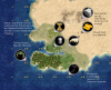
You're absolutely right, I did look at a map and I thought I had placed it in the correct place. I don't know if things changed in my head or if my map wasn't good. I've moved it. I tried 3E instead of 1S3E to give Khartoum a bit more place. Do you think this works? (see image below)
With Ethiopia, my reasoning was that the highlands are themselves landlocked, Axum conducted trade through the port of Adulis, which would be on that new land tile. I also wanted a situation where Ethiopia could lose sea access and keep its core (ie, as today). If I recall correctly, the fall or decline of Adulis was an important factor in the decline of Axum. I thought Zeila/Djibouti could serve to provide the sea access and keep this vulnerability there. Don't feel strongly about it.
Here's a different possibility, which is to include Adulis in the game, and make room for that by shifting the highlands 1W, but bear in mind that Gondar and Bahir Dar had already been shifted 1W earlier. I would then move Khartoum and Juba also 1W (haven't done in the image) to make room for them and readjust the terrain (move the lake west, etc). This would take some room away from the Sahel region between Chad, Central African Rep, and Southern Sudan... which I think is completely fine. After trying this, this idea is growing on me. Here's how it looks (including the change of Meroe):
Spoiler :
What do other people think?
I would personally place Kilwa 1S1E, on the new land tile.
I don't think that all of your city suggestion should be the canonical cities. (More isn't always better. I this case, it isn't IMO) I would say the following cities are the canonical cities of the Swahili Coast: Mogadishu, Mombasa, Zanzibar, Kilwa, Mozambique and Sofala. This also allows Mombasa and Zanzibar to be placed on the accurate tile and make the area less crowded. (I think it is too crowded in your suggestion).
Yeah, as with Egypt, I tried shifting cities a bit to accommodate more of them. I have put now Mombasa, Zanzibar and Kilwa in their accurate locations (all were 1N). In Mozambique, I replaced Pemba with Mozambique (which nevertheless I thought was only of importance in the context of the Portuguese colonization, and not so much for the Swahili themselves). I removed Quelimane but left Maputo for now. This is how that looks like. What do people think?
Spoiler :
merijn_v1
Black Belt
I now see I said Mozambique instead of Quelimane. I prefer Quelimane as a canonical city over Mozambique. Sorry for the confusion.
I found out that Khartoum was only founded in 1821. The timelines of Meroë and Khartoum are so different that they should not coexist at all, even if there is room for both. So I think that Meroë can should be placed 1S, which is IMO more accurate. There shouldn't be a conflict between both after all.
You're absolutely right, I did look at a map and I thought I had placed it in the correct place. I don't know if things changed in my head or if my map wasn't good. I've moved it. I tried 3E instead of 1S3E to give Khartoum a bit more place. Do you think this works? (see image below)
I found out that Khartoum was only founded in 1821. The timelines of Meroë and Khartoum are so different that they should not coexist at all, even if there is room for both. So I think that Meroë can should be placed 1S, which is IMO more accurate. There shouldn't be a conflict between both after all.
Last edited:
Okay, so my (incomplete) perspective on ozqar's suggestions for Africa:
- I really like the approach of mapping out the modern borders first, my geographic knowledge of Africa is rather limited in places so this definitely helps mapping the map to reality
- I don't think I like moving the Nile or the upscaled delta. The stated goal is to increase space for Egypt but it doesn't really seem to do so. In my opinion the goal here should be to have one in Upper and one in Lower Egypt (i.e. Thebes and Memphis, or Aswan/Elephantine instead of the former). By actually moving Thebes 1N1W you reduced the available space for ancient Egypt. I know it is more geographically accurate, but I think it's a good thing that the previous arrangement stretched Egypt north of Aswan to the south (the current map does that to an even greater degree). Moving the Nile west doesn't seem to do anything to solve these problems. For example, one of the problems is the distance between Cairo and Alexandria but it's the same in both versions. On the other hand the unchanged one is closer to reality.
- Likewise, I am not sure Ethiopia needs to be moved. Obviously the current configuration needs to be changed so Aksum can exist, but maybe that is possible by only rearranging the peaks there. Aksum 1N1E of Lake Tana seems to alright. Initially I was also a opposed to coastal Aksum but merijn makes some good points. Still it would be cooler to have Adulis as well.
- In general I think you were too aggressive in removing peaks, it is nice to have some texture to the terrain e.g. in the south of Ethiopia. Also I think some peaks in the Rift Valley should remain so that it remains impassable, separating East Africa from the Congo basin.
- My previous research into climate regions in the area does not support grassland coast in East Africa. Satellite imagery may be misleading because summer peak savannas are also very green but not fertile enough to justify grassland. But if you have different information I am open to have my mind changed.
I think that's it. Hopefully you don't take it as too negative because this is overall a very well researched and put together proposal. I only want to focus on the areas that need improvement or further discussion or where I think this diverges from my goals or standards. In particular, the reshaping of the coastline seems right, although I can only give a complete judgment after rebuilding them in WB. Also all these city names are extremely helpful, I prefer the second proposal for the Swahili coast.
DC123456789
Deity
Does Aswan even remotely compare to the importance of Thebes/Luxor? I would think that if we can only have one city in Upper Egypt, Thebes would clearly be the one to have. It's larger even today.
No, and yes. I'm just saying that the player could swap out Thebes for Aswan with little consequence to what we're doing with the map.
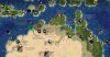
Colorado and the US rockies in general have a fair amount of forests. We should add some, maybe like this:

And speaking of forests, I wanted to ask if there's a reason why many places seem to lack them when they would have been forested in ancient times. For instance, a lot of Europe (e.g. Denmark and the entire German coast) and most of the North American Atlantic seaboard. Is it a gameplay concern?
Spoiler :
And speaking of forests, I wanted to ask if there's a reason why many places seem to lack them when they would have been forested in ancient times. For instance, a lot of Europe (e.g. Denmark and the entire German coast) and most of the North American Atlantic seaboard. Is it a gameplay concern?
I'm not sure, you're right that historically they were covered entirely in forests.
pernas
Chieftain
- Joined
- Aug 7, 2016
- Messages
- 35
Why are there so many mountains in Brazil? Pretty much the whole country is quite hilly and filled with plateaus, but there aren't actually any real mountains, the highest "mountain" is just under 3000 meters high. The current mountain placement also makes the economic heartland of the country significantly worse for no good reason.
FraggleJock
Warlord
- Joined
- Jun 25, 2017
- Messages
- 151
Australia.
I find the shape of the Murray/darling river system in the new map disturbing, and poor Tasmania! Here's my suggestions
the resource spawn dates were selected as approximation for the first waves of Europeans away from the first colonial sites (1830) and the post war migrant inflow that pushed inward again (1920)
SA, Vic, Tas
Make it a choice between Melbourne/Geelong and if you build Adelaide or a couple of smaller cites in SA. or go completely Ahistorical and have a mega city at the mouth of the Murray

NSW, Southern Queensland and the Red Centre
Sydney for a good city now or Lithgow for potential 100 years later and some junk towns over the divide to grab all the goodies
How do you best exploit Queensland?

The Top End
Being mean to the Territory, it's not developed now why should civ Oz have it any better.

Perth
There can be only one, or maybe two if you feel odd

I find the shape of the Murray/darling river system in the new map disturbing, and poor Tasmania! Here's my suggestions
the resource spawn dates were selected as approximation for the first waves of Europeans away from the first colonial sites (1830) and the post war migrant inflow that pushed inward again (1920)
SA, Vic, Tas
Make it a choice between Melbourne/Geelong and if you build Adelaide or a couple of smaller cites in SA. or go completely Ahistorical and have a mega city at the mouth of the Murray
NSW, Southern Queensland and the Red Centre
Sydney for a good city now or Lithgow for potential 100 years later and some junk towns over the divide to grab all the goodies
How do you best exploit Queensland?
The Top End
Being mean to the Territory, it's not developed now why should civ Oz have it any better.
Perth
There can be only one, or maybe two if you feel odd
Attachments

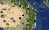
Tas has been debated to no end and I think 3 tiles is the settled on number to discourage settling a city on it. Overall, seems a bit resource dense. Tundra and oases doesn't really make sense where they are and there's better ways to ensure correct city placement.Australia.
I find the shape of the Murray/darling river system in the new map disturbing, and poor Tasmania! Here's my suggestions
the resource spawn dates were selected as approximation for the first waves of Europeans away from the first colonial sites (1830) and the post war migrant inflow that pushed inward again (1920)
SA, Vic, Tas
Make it a choice between Melbourne/Geelong and if you build Adelaide or a couple of smaller cites in SA. or go completely Ahistorical and have a mega city at the mouth of the Murray
NSW, Southern Queensland and the Red Centre
Sydney for a good city now or Lithgow for potential 100 years later and some junk towns over the divide to grab all the goodies
How do you best exploit Queensland?
The Top End
Being mean to the Territory, it's not developed now why should civ Oz have it any better.
Perth
There can be only one, or maybe two if you feel odd
FraggleJock
Warlord
- Joined
- Jun 25, 2017
- Messages
- 151
can you make a terrain feature like Capes that triples water movement to spread around the Indonesian archipeligo so it doesn't take 10,000 years to sail around Java?
Maybe the map size increase justifies a flat movement increase for most ships but otherwise I think things are alright.
I made this comment ages ago but since I'm not playing the game at the moment I can't make screenshots. To add to Soul's changes, I think there should be more peaks in south central and southwest China to reduce the number of tiles for Changsha, Chongqing, and Chengdu, and the break up these regions. Chongqing should have peaks in the inner ring and Changsha and Chengdu in the outer ring. Changsha to the northwest and southwest, and Chengdu in every direction.
Also Nanjing as a hill tile would help its historic situation. As Jiankang it was the capital of many kingdoms and important in war.
Also Nanjing as a hill tile would help its historic situation. As Jiankang it was the capital of many kingdoms and important in war.
soul-breathing
Emperor
My suggestion is add some marshes/Jungles in South China, and turn to plains and appear some food resourses after XXX year. But I have not complete a concrete plan.I made this comment ages ago but since I'm not playing the game at the moment I can't make screenshots. To add to Soul's changes, I think there should be more peaks in south central and southwest China to reduce the number of tiles for Changsha, Chongqing, and Chengdu, and the break up these regions. Chongqing should have peaks in the inner ring and Changsha and Chengdu in the outer ring. Changsha to the northwest and southwest, and Chengdu in every direction.
Also Nanjing as a hill tile would help its historic situation. As Jiankang it was the capital of many kingdoms and important in war.
In fact there not so many peaks in South China, most of the mountains in South China are about 2000 meters in altitude. The peaks are at most settle in the West Region.
I still think a better way to keep China out of the South early on is to add the Yue.My suggestion is add some marshes/Jungles in South China, and turn to plains and appear some food resourses after XXX year. But I have not complete a concrete plan.
In fact there not so many peaks in South China, most of the mountains in South China are about 2000 meters in altitude. The peaks are at most settle in the West Region.
soul-breathing
Emperor
It's unsuitable to add a civ which is not existed in history. If you feel it necessary to add a Yue civ, it could be like Polynesia and Harappa, only spawn when human players use it.I still think a better way to keep China out of the South early on is to add the Yue.
Since 221BC, Guangdong had been controlled by Chinese dynasties.
Similar threads
- Replies
- 3
- Views
- 695
- Replies
- 61
- Views
- 6K
- Replies
- 27
- Views
- 6K
- Replies
- 5
- Views
- 692