Ok, propositions about terrain, cities and resources.
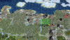
Kola peninsula and Karelia.
View attachment 498191
Most of Karelia converted into moorlands+taiga; seashore - to moorlands+forest. (moorlands in green border)
Most canonical city is Murmansk, but though first Russian settlements here was found at late MA, region was underpopulated and underdeveloped before XX century.
Also it is possible to found Kem' in Karelia, small but old trade post in White Sea.
Another city spots blocked by taiga.
Added hill with stone (or, probably, marble) in St.Peterburg BFC, to represent Karelian quarries (Ruskeala and other sources of raw materials for St.Peterburg).
Added whales, to represent Svalbard. (?)
Added iron (after 1900-1930 AD), representing discovered nickel deposits in Pechenga/Petsamo region.
Added crabs (after 1930-1950 AD), representing introduction of Kamchatka crabs into Barents Sea by USSR in XX century.
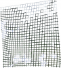
Russian North region.
View attachment 498192
Same, most of region covered by moorland+taiga, and river banks - by moorland and forest.
Tundra starts in seashores of Barents Sea 2N and 2E of Arkhangelsk. Two tiles 1N and 1E of Onega Lake covered by plains instead of moorlans - bonus hammer represents local industry (small deposits of bauxite and cement)
Added cows 1E of Kholmogory, representing local breeds of cattles and compensating loss of food after converting grasslands to moorlands and taiga.
Added salt between Kholmogory and Ustyug (here, or 1E/S/SE) - salt of Sol'vychegodsk was source of income for Siberia colonization at the times of Russian Tsardom.
I added gem mine near the Arkhangelsk, but really don't know about it. Though Lomonosov diamond mine is largest in Europe, it was discovered relatively recently (at 1980s) and such late spawn is useless, but presence at map since 3000 BC is tasteless too.
Nenetsia+Komi.
Mostly unprofitable region, known mostly by oil.
Towns marked as checkpoints, don't think that AI should necessary found them.
Added oil for oil/gas deposites in the Nenetskiy District.
Added deers to represent indigenous tribes.
Gems here makes me confused since vanilla RFC, because there are no much sources of precious gems at the North Ural. Removed, placed coal (mines of Vorkuta).