Are coconuts fruit?
- Home
- Forums
- CIVILIZATION IV
- Civ4 - Creation & Customization
- Civ4 - Project & Mod Development
- Civ4 - Rhye's and Fall of Civilization
- Rhye's and Fall - Dawn of Civilization
You are using an out of date browser. It may not display this or other websites correctly.
You should upgrade or use an alternative browser.
You should upgrade or use an alternative browser.
[Development] Map Suggestions
- Thread starter Leoreth
- Start date
merijn_v1
Black Belt
It depends which terminology of fruit you use. In a botanical sense, a fruit is the "plant product". I generalized "plant products" with the word fruit. I think that "palm fruit" sound much better than "product from a palm tree" or "palm product". And apperantly it isn't even inaccurate.
Even if it was a nut, it would still be a fruit botanically. A nut is a type of fruit apperantly.
From a culinary point, I wouldn't call it a fruit though.
wikipedia said:
Even if it was a nut, it would still be a fruit botanically. A nut is a type of fruit apperantly.
wikipedia said:Many common terms for seeds and fruit do not correspond to the botanical classifications. In culinary terminology, a fruit is usually any sweet-tasting plant part, especially a botanical fruit; a nut is any hard, oily, and shelled plant product; and a vegetable is any savory or less sweet plant product.[5] However, in botany, a fruit is the ripened ovary or carpel that contains seeds, a nut is a type of fruit and not a seed, and a seed is a ripened ovule.
From a culinary point, I wouldn't call it a fruit though.
ozqar
King
Well, I'm also very unsure about how to feel about having dates and coconut as varieties of a single resource, partly because, as merijn says, they're used very differently - which actually makes me think that a name such as "palm fruit" does not say too much. I think in general, palm trees (all of them) are used as a source of textile and (semi) industrial fibers, and for construction materials, etc.
Beyond that, their fruits do have different uses. Coconuts can provide oil, but they're main use is as a nutrient source (oils, but for edible purposes, proteins), dates are also very high on nutrients (proteins), and I think we need to add palm oil fruit to the discussion - which is mostly used to extract edible oils.
Hence, I wonder if grouping them as varieties of a "palm" resource makes sense. For every other resource type, we're grouping things by their use, not their biological taxonomy. Dyes and spices are the best examples. So, I'd rather propose that we add these two (or three) varieties grouped with similar-used things. So, for example, let's put olives and oil palm as varieties of each other (if necessary, the resource can be called "oil crops" or "edible oils").
If you're looking for a fruit resource for arid types, then a group including date palms, pomegranate (not sure if there's art), and the fruit of the prickly pear cactus (art in C2C) could do that. Combining all three, you do have almost cosmopolitan representation (dates for MENA, pomegranates for Iran, Central Asia, and Northwestern India, prickly pear for the Americas), in Australia there's a fruit called quandong that I think could fit in here as well (although it might not be necessary).
As you showed, coconuts are coastal-only resources, and live in tropical (not temperate) regions, so not in regions like MENA. I think that they would be great for flavor in Polynesia and other coastal regions, so I'd leave them on their own. As a note, if we three palm types are not possible, then merging coconuts and oil palms would make sense; coconuts are at least somewhat used for oil.
By the way, before we mentioned peyote and coca plant as potential varieties for opium. There's also art for kava root, which has a similar use in Polynesia. I don't know if opium has traditional spiritual uses in its region, but if it does, then using all four together as a varieties of a resource (which all the more could generate happiness especially under pagan religions), would be super nice.
Edit: didn't see the questions before. Yes, for all our purposes coconuts are fruits, not nuts (it's an unfortunate name only, just like how pineapples aren't types of apples), they're as much a fruit as peaches (biologically speaking, they're drupes).
Edit 2: just learnt that with kava what you consume is the roots, not the fruit. edited that.
Last edited:
Publicola
King
- Joined
- Apr 26, 2014
- Messages
- 763
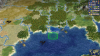
I have a suggestion for the Mississippi river delta in North America. The 'New Orleans' tile was recently changed to a lagoon, with the Mississippi river flowing into the Gulf of Mexico along the northern edge of the tile.
Could we adjust the river so it flows into the ocean off the southern edge of the tile instead? Here's a screenshot of how it would look -- I think the river banks make the tile look a lot like the Lousiana bayou.

Could we adjust the river so it flows into the ocean off the southern edge of the tile instead? Here's a screenshot of how it would look -- I think the river banks make the tile look a lot like the Lousiana bayou.
Spoiler Mississippi fix :
Attachments
Enyavar
Prince
- Joined
- May 16, 2015
- Messages
- 517
Palms provide a wide variety of uses. Some are clearly represented by increasing food yield (dates, coconut), but others are clearly not and are better represented by commerce or production. However, I think this can be ommited by only concerning palms with edible fruits. Then I think the name "palm fruit" would be nice. At first I thought this would be very generic, but I'm starting to like it more and more.
That is true; cocos palms are not only used for the coconuts. The entire tree was put to good use in pre-industrial societies. The interior of the nuts has first the coconut juice ("milk") which is separated from the coconut pulp which is again the base for coconut oil . The remains of the pulp were usable as fertilizer. The outer bast fibers of the nuts were used to fashion ropes, mats or even sails. Palm leaves were used to construct roofs, while their tips can even be used as vegetables. Toddy is produced from carefully harvesting the trunk (if you take too much, the tree dies); and finally the wood may be inferior but was still used in construction.
Cocos commercial worth in the 1900s was measured in millions of currency, and my numbers are only for export from the island of Ceylon, neglecting the domestic economy. Over 80% of that cocos product export worth was directly derived from the coconut fruits themselves, though. Meanwhile, in the same time, British Ceylon's production of cinnamon and coffee put together was not even half the worth of coconuts. The most important produce of the island was tea, however, worth between two or three times the amount of coconuts. Although market prices are volatile: a few centuries before, cinnamon was the main export Ceylon was famous for, and just a short time after 1900, coffee overproduction led to plummeting prices. Even today, tea overshadows all other agricultural exports of Sri Lanka, followed by rubber, gems, cocos and coffee. Spices are rather an afterthought, today.
This is an excellent suggestion. It’s interesting that what is basically a map artifact turns out to look so much like the very elongated Mississippi delta.I have a suggestion for the Mississippi river delta in North America. The 'New Orleans' tile was recently changed to a lagoon, with the Mississippi river flowing into the Gulf of Mexico along the northern edge of the tile.
Could we adjust the river so it flows into the ocean off the southern edge of the tile instead? Here's a screenshot of how it would look -- I think the river banks make the tile look a lot like the Lousiana bayou.
Spoiler Mississippi fix :
As I have said elsewhere I would also move the islands from east to south of New Orleans to better represent the coastal areas.
BarbarianX
Chieftain
- Joined
- Nov 4, 2013
- Messages
- 54
I have revised my Iceland suggestion, and following the criticisms given, I removed one of the peaks, changed some of the Moorlands to Tundra, and removed 1 Sheep, the Horses and Fur. I also added the Vestmanneyjar Islands in the south coast.
.png")
Spoiler Iceland :
I don't remember if I already posted this but do we think horses are significant enough in India's history to have them placed on the map from the beginning? I think maybe they should be a spawning resource as they are not native to India and not hugely important throughout much of the history, but I'm not sure when they should spawn.
Also, on the note of horses and varieties is there any horse varieties out there we might want to include in this push for resource varieties?
Also, on the note of horses and varieties is there any horse varieties out there we might want to include in this push for resource varieties?
DC123456789
Deity
My suggestion for Hudson Bay (from the other thread):

I didn't actually end up doing anything with the west coast. Looking at a Robinson projection you could feasibly move the northern part of it 1E, but when I tried that it looked really bad. Instead, I moved Southampton Island 1S, with adjustments to the Melville Pennisula to compensate. This does make it so that there's only 1 tile that lets you enter Hudson's Bay; if this is a problem you could replace the Coats Island tile with some islands, but I think this looks better (not to mention that navigation into the bay is pretty unimportant in any case). I also added a land tile to northern Quebec to better show the large "lobe" north of James Bay. It could feasibly be 1S, but I think this looks better.
I also took the opportunity to add some marshes around Great Slave Lake and Lake Athabasca:

This is a pretty minimalist suggestion, they could feasibly be larger I think (not that it really matters given that it's replacing useless terrain in the first place). The fur tile became a marsh, so I moved it 2E so that it's in Yellowknife's BFC.
I also made some adjustments and additions to the Hudson Bay Lowlands marshes:

Basically I expanded it a little bit along each side of the coast, as well as moving the inland marsh tile E to be more accurate (without totally cutting off the Fort Albany tile by land).
Spoiler :
I didn't actually end up doing anything with the west coast. Looking at a Robinson projection you could feasibly move the northern part of it 1E, but when I tried that it looked really bad. Instead, I moved Southampton Island 1S, with adjustments to the Melville Pennisula to compensate. This does make it so that there's only 1 tile that lets you enter Hudson's Bay; if this is a problem you could replace the Coats Island tile with some islands, but I think this looks better (not to mention that navigation into the bay is pretty unimportant in any case). I also added a land tile to northern Quebec to better show the large "lobe" north of James Bay. It could feasibly be 1S, but I think this looks better.
I also took the opportunity to add some marshes around Great Slave Lake and Lake Athabasca:
Spoiler :
This is a pretty minimalist suggestion, they could feasibly be larger I think (not that it really matters given that it's replacing useless terrain in the first place). The fur tile became a marsh, so I moved it 2E so that it's in Yellowknife's BFC.
I also made some adjustments and additions to the Hudson Bay Lowlands marshes:
Spoiler :
Basically I expanded it a little bit along each side of the coast, as well as moving the inland marsh tile E to be more accurate (without totally cutting off the Fort Albany tile by land).
I approve of these suggestions! In addition, I would fill the tiles east of James Bay (south of Hudson's Bay's curved coastline) with taiga. Ditto for the two hill tiles in the middle of Quebec, SW of the lake in Labrador.
Also, how about adding Lake Mistassini 1N of the iron, discharging into the Rupert River. It is Quebec's largest non-reservoir lake, and it feels wrong that northern Quebec has no lakes when in fact it is dotted with 3.6 million of them.
Also, how about adding Lake Mistassini 1N of the iron, discharging into the Rupert River. It is Quebec's largest non-reservoir lake, and it feels wrong that northern Quebec has no lakes when in fact it is dotted with 3.6 million of them.
soul-breathing
Emperor
It's possible for New Orleans to build Delta Works, which is only can be built in Amsterdam in 1.16 version.I have a suggestion for the Mississippi river delta in North America. The 'New Orleans' tile was recently changed to a lagoon, with the Mississippi river flowing into the Gulf of Mexico along the northern edge of the tile.
Could we adjust the river so it flows into the ocean off the southern edge of the tile instead? Here's a screenshot of how it would look -- I think the river banks make the tile look a lot like the Lousiana bayou.
Spoiler Mississippi fix :
stormogulen
Chieftain
- Joined
- Jul 6, 2019
- Messages
- 65
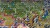
Today I jump from cold Scandinavia to... the deserts of Afghanistan and Balochistan!
Marked some cities in the area for easier orientation, not completely sure if all locations are as accurate as possible.
First Afghanistan (and a little Iran and Turkmenistan):

Blue tiles are changed to semidesert, yellow tiles changed to desert. Herat tile changed to plains. Inaccurate forests removed from western parts of country, coniferous forest added to Kabul tile and to the deer tile 2S of Kandahar. The Quetta and Kandahar tiles are changed to hills, as is the cotton tile 1N of Herat. Quetta forest changed to coniferous (known for Juniperus macropoda and Chilghoza pine). Oasis added to Kandahar.
I also made some terrain changes in Iran and Turkmenistan. Replaced a coast tile with a salt lake in the Caspian Sea, representing Garabogazköl (https://en.wikipedia.org/wiki/Garabogazköl), and added two salt flats in Dasht-e Kavir in Iran (red area). Also slightly rearranged the mountains between Iran and Turkmenistan. The added mountain north of Mashhad can be considered as part of the Kopet Dag range (https://en.wikipedia.org/wiki/Kopet_Dag).
Resources:
Gems (2N1E of Kabul): moved to represent lapis-lazuli from Badakhshan (could alternatively represent spinel, with the new ruby art).
Silver: primarily represents the silver mines of Panjshir valley. Central Asia was a very important center for silver mining during the middle ages (particularly the Samanid period), stimulating trade with northern Europe (https://journals.openedition.org/histoiremesure/892#text). I propose to also/alternatively add a silver resource to Tashkent, famous for silver mining in that era. These resources could then expire by 1000-1100 AD or so, when the flow of silver stopped.
Opium (1SW of Kandahar): moved one towards the notorious provinces in the south (Helmand and Kandahar)
Gems (1W of Mashhad, Iran): represents turquoise from Ali-mersai mountain
Other than that, I made some small rearrangements (e.g. moved a sheep 1S from Peshawar) and gave Turkmenistan a sheep and a salt.
Now Balochistan:

The main change is to replace two hills with peaks, mostly representing the Brahui Range marked in this picture: https://upload.wikimedia.org/wikipedia/commons/9/9b/Pakistan_Mountain_Ranges_BMNG.jpg. I think this makes sense considering gameplay, as being able to easily pass from Persia to India or vice versa through these tiles seems quite unrealistic IMO. Also, I think it looks nice. The marked tiles are changed to hills (Balochistan is very rugged, with the Makran mountain ranges running through it as shown in the picture linked above). The incense is moved here from a bit north and represents aromatic plants in the area (noted by Alexander the Great's men on their journey through the area). Not sure if the path between Persia and India in the south should be blocked by desert.
Marked some cities in the area for easier orientation, not completely sure if all locations are as accurate as possible.
First Afghanistan (and a little Iran and Turkmenistan):
Spoiler Afghanistan etc :
Blue tiles are changed to semidesert, yellow tiles changed to desert. Herat tile changed to plains. Inaccurate forests removed from western parts of country, coniferous forest added to Kabul tile and to the deer tile 2S of Kandahar. The Quetta and Kandahar tiles are changed to hills, as is the cotton tile 1N of Herat. Quetta forest changed to coniferous (known for Juniperus macropoda and Chilghoza pine). Oasis added to Kandahar.
I also made some terrain changes in Iran and Turkmenistan. Replaced a coast tile with a salt lake in the Caspian Sea, representing Garabogazköl (https://en.wikipedia.org/wiki/Garabogazköl), and added two salt flats in Dasht-e Kavir in Iran (red area). Also slightly rearranged the mountains between Iran and Turkmenistan. The added mountain north of Mashhad can be considered as part of the Kopet Dag range (https://en.wikipedia.org/wiki/Kopet_Dag).
Resources:
Gems (2N1E of Kabul): moved to represent lapis-lazuli from Badakhshan (could alternatively represent spinel, with the new ruby art).
Silver: primarily represents the silver mines of Panjshir valley. Central Asia was a very important center for silver mining during the middle ages (particularly the Samanid period), stimulating trade with northern Europe (https://journals.openedition.org/histoiremesure/892#text). I propose to also/alternatively add a silver resource to Tashkent, famous for silver mining in that era. These resources could then expire by 1000-1100 AD or so, when the flow of silver stopped.
Opium (1SW of Kandahar): moved one towards the notorious provinces in the south (Helmand and Kandahar)
Gems (1W of Mashhad, Iran): represents turquoise from Ali-mersai mountain
Other than that, I made some small rearrangements (e.g. moved a sheep 1S from Peshawar) and gave Turkmenistan a sheep and a salt.
Now Balochistan:
Spoiler Balochistan :
The main change is to replace two hills with peaks, mostly representing the Brahui Range marked in this picture: https://upload.wikimedia.org/wikipedia/commons/9/9b/Pakistan_Mountain_Ranges_BMNG.jpg. I think this makes sense considering gameplay, as being able to easily pass from Persia to India or vice versa through these tiles seems quite unrealistic IMO. Also, I think it looks nice. The marked tiles are changed to hills (Balochistan is very rugged, with the Makran mountain ranges running through it as shown in the picture linked above). The incense is moved here from a bit north and represents aromatic plants in the area (noted by Alexander the Great's men on their journey through the area). Not sure if the path between Persia and India in the south should be blocked by desert.
Sounds like New Orleans of all places would be an appropriate alternative location for a system of dams and sluices that protect it from the sea.It's possible for New Orleans to build Delta Works, which is only can be built in Amsterdam in 1.16 version.
It's possible for New Orleans to build Delta Works, which is only can be built in Amsterdam in 1.16 version.
Sounds like New Orleans of all places would be an appropriate alternative location for a system of dams and sluices that protect it from the sea.
Likewise, New Orleans can currently build the Delta Works on the current map, just like Amsterdam. Just like Steb I feel that it's appropriate for that to remain possible in the new map (also so that the wonder isn't restricted to one city).
Well I know it had quite a few bridges ...I had a thought: should there be a lagoon tile in the Konigsberg area? I’m not sure to what extent the city is/was built on water, but there are definitely large lagoons in its vicinity.
Königsberg is at the Vistula Lagoon but not really built on top of it, but representing the lagoon is a nice idea at least, even if it's just lagoon + marsh. I have to look at the area anyway to account for the Baltic Sea proportions so I will try some possibilities.
Edit: actually, let me correct that. The city is right between the Vistula Lagoon and the Curonian Spit, both of which qualify as lagoons, which to me is a good justification to make the city tile a lagoon entirely. Map suggesters rejoice, it is the Return of the König(sberg).
Last edited:
Yeah, the existence of the seven bridges of Königsberg is pretty much the extent of my knowledge of the city’s geography...
Ok, combining the two recent topics here, should Amsterdam (and maybe Rotterdam) be a lagoon tile? I’m not sure, and I assume we don’t want all cities with canals to be lagoons, but Amsterdam is definitely a strong candidate with the Zuiderzee/IJsselmeer next to it. And then the criterion for the delta works could be that the city is on a lagoon. Then it could be built in e.g. Venice, where it would appropriately represent the MOSE project, as well as New Orleans and other cities that are vulnerable to flooding.
Ok, combining the two recent topics here, should Amsterdam (and maybe Rotterdam) be a lagoon tile? I’m not sure, and I assume we don’t want all cities with canals to be lagoons, but Amsterdam is definitely a strong candidate with the Zuiderzee/IJsselmeer next to it. And then the criterion for the delta works could be that the city is on a lagoon. Then it could be built in e.g. Venice, where it would appropriately represent the MOSE project, as well as New Orleans and other cities that are vulnerable to flooding.
ozqar
King
I think Amsterdam is a good candidate (Rotterdam not so much, because the map would look very weird since you can't settle them both). Built on a lagoon seems a great criteria to restrict the Delta Works, but then restrict it to coastal cities to avoid it being built in Mexico City.
On the other hand, I'd like to suggest removing the lagoons in New York, Hong Kong, Porto Alegre, and Maracaibo (if that last one was placed), where we're using the terrain to better mimic the shape of the coastlines, but where I don't think the city's actual geography justifies a lagoon tile. Tenochtitlan, Amsterdam, Venice, New Orleans (perhaps Hamburg and St Petersburg are other good candidates) where all built over water (or at least swamps). I think the bonus (and the graphical use) of lagoons should be restricted to these cities.
On the other hand, I'd like to suggest removing the lagoons in New York, Hong Kong, Porto Alegre, and Maracaibo (if that last one was placed), where we're using the terrain to better mimic the shape of the coastlines, but where I don't think the city's actual geography justifies a lagoon tile. Tenochtitlan, Amsterdam, Venice, New Orleans (perhaps Hamburg and St Petersburg are other good candidates) where all built over water (or at least swamps). I think the bonus (and the graphical use) of lagoons should be restricted to these cities.
Yeah, I have a bit of trouble getting a coherent picture of what the lagoon tile should be used for. Outside of obvious situations like Venice, should the tile represent lagoons as geographical features, or cities built on water? My personal feeling is that there should be at least something resembling a geographical lagoon to justify the tile.
Thus I think Porto Alegre and Maracaibo make sense as lagoons because there are large lagoons next to these cities even if they are mostly on land. After all, Maracaibo is where Venezuela got its Little Venice nickname.
Hamburg and St. Petersburg don’t have a lagoon even if they are built on swampy areas. Hong Kong also doesn’t have anything like a lagoon, it’s just a peninsula and islands. I would also remove the lagoon at New York; I suppose it could be justified because of the New York bay but I don’t think it really fits. If anything, Chesapeake Bay would be more lagoonish but it wouldn’t really have a city built on it.
Crimean Lord
Warlord
SOUTH PART of SIBERIA
ECONOMIC and HISTORICAL BACKGROUND
Until beginning of XX century it was unsettled area, the biggest city of Siberia NOVOSIBIRSK (1 500 000) founded only in 1890-s and it convert into really important city in the second part of XX century;
(except one important case - Mountain province of TUVA was part of Emperor's CHINA and conqured by USSR in WW II;
In Soviet Times and also nowadays two factors assosiated with South Siberia:
1) Aluminium's Mines of Hakasia (plains and semi-desert area)
2) Powerfull Coal Deposites in Kuzbass (main local city is Kemerovo)
SOME SUGGESTIONS (Resources + Terrains)
* One ALUMINIUM near Novosibirsk (two tiles SW Novosibirsk) - it represents famous symbol of aluminium industry of Siberia - city ABAKAN;
* A least one (or even two) COAL (two tiles NE Novosibirsk) - it represents MAIN source of Coal in USSR and also modern Russia - area of KUZBASS and its center - city KEMEROVO;
* Two new marhes near Kemerovo's COAL - perhaps it's not geograficaly accurate but it could nerf mega city in this part of the World*
* Siberian Sheeps removed from River to Western Sajan's Mountains (which illustrated as semi-desert Hills and Rock) - I think it's not very important;
* One INCENCE and one CAMEl in TUVA (unpopuleted mountain land between South Siberia and Mongolia, de-facto key-area of the Russian Buddism) - not so important for huge Russia but perhaps it will be usefull for Mongolia;
P.S. I don's know any reasons why there was one Сoal near Irkutsk - so I propose delete this Coal (at least area of KUZBASS more important);
Attachments
Last edited:
Similar threads
- Replies
- 3
- Views
- 695
- Replies
- 61
- Views
- 6K
- Replies
- 27
- Views
- 6K
- Replies
- 5
- Views
- 692