Ok, I had a chance to mess around with World Builder tonight, and I think I have an idea to increase the visual interest of the map without adding any gameplay mish-mash complexity.
I am hypothesizing that I can make convincing giant sand dunes in the deep desert. Let me explain how I think this can be done. To make the idea work best, I would need a terrain texture for land and hills that matches the color of the 'deep desert' exactly, while also behaving the same way in gameplay terms, even though one is 'ocean' and the other is 'land'. (no city building, etc.)
Using these three altitudes of 'deep desert', the 'ocean' would be the valleys, the hills would be the tops of the dunes, and the land would be in-between. Having only three altitudes is not great, but if drawn properly on the map, using the right terrain texures, it might be enough to sell the illusion.
The dunes would be drawn by superimposing a dune texture over the map altitudes to decide what altitude of deep desert to use on a map square. The further you are from any continents the more of this texture is used for dunes, while the closer you are to a continent less of the texture comes through and is basically flat around the continents. It's kindof like a blended in bump-map on a macro scale.
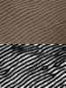
Here is an example of a texture I could use, that I downloaded from some random site on the internet. I would texturize this pattern for wrapping and then convert it into altitude data.
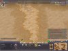
To get more of an idea of how this data would be used, I cooked up a mock up with world builder. The mini-map shows something of a dune shape, but instead of my lame brush work it would be generated procedureally and look much better. I am using regular 'desert' terrain, though it would be better to use something that matched the 'deep desert'. Also, with WB you get 'coast' adjacent to land, but with a map script you don't actually need to place coast. Land can actually just butt right up to ocean. Try to imagine there is no 'coast' around this dune...
What do you guys think?
") I think I know exactly how to make a convincing shield wall.
I think I know exactly how to make a convincing shield wall.