Hurricane Isabel

Quasar1011

King of Sylvania
Joined
May 17, 2003
Messages
2,968
Location
California
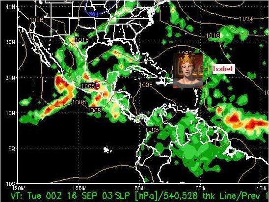
As a meteorologist, I am concerned about Hurricane Isabel. It will be hard for this storm to miss striking the United States. It is too early too tell, but if any of you here at CFC live near the coast in the southeastern USA, please pay close attention to news about this storm. It is already a category 4 hurricane, so any landfall it makes will be devastating, unless it loses intensity.
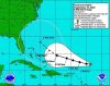
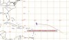
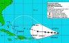
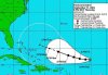
Here is a computer model showing where Isabel is projected to be at 7 p.m. EST on Monday the 15th:
 

Attachments

  • 16_00z.jpg
    16_00z.jpg
    75.7 KB · Views: 285
If Isabel weakens, it will likely be from upper-level shearing. At the lower levels, it looks like it will avoid striking the mountainous islands of Hispaniola and Cuba. So the other low-level influence is the sea-surface temperatures (SSTs). I have attached a chart below of observed SSTs from this morning, 10 Sep. As you can see, Isabel is moving towards even warmer water. This would allow it to maintain its strength, or grow even stronger, thus my concern. Hopefully it will enter a shear zone and weaken. But, stay tuned...
 

Attachments

  • ssts.jpg
    ssts.jpg
    43.4 KB · Views: 245
You know, I bet that's what is causing all the rain up here in South Dakota. Is that a possibility?

Indeed, beware of Hurricane Isabel....

isabel.JPG
 
Originally posted by CivCube
You know, I bet that's what is causing all the rain up here in South Dakota. Is that a possibility?
No, it isn't. Which is why I cut the map off in Nebraska. :p
 
Thanks for the reminder, Quasar1011. Even though I live 100 or so miles inland, we've had several hurricanes in recent years of sufficient strength to cause us some problems. These days I start paying attention to the progress of tropical depressions, LOL.
 
I have a good friend in Miami. You can see why I'm concerned. Here is the latest official projected path from the National Hurricane Center:
 

Attachments

  • isabel10_5pm.jpg
    isabel10_5pm.jpg
    83 KB · Views: 225
The hurricane definately isn't causing the rain in the central US. That's from a strong low pressure system moving into the plains and feeding off the gulf moisture. I don't really mind the rain in Nebraska, yesterday was the first time it rained at my house in over a month.

I've been paying attention to Isabel for about the past 3 days and the people down south should start to pay close attention. It doesn't look like much of anything is going to hinder Isabel at this point. I have a feeling this one could become the next Hugo or Andrew.
 
Only one hurricane I can remember made it up to New York. How strong was it? Let me put it this way. I went out shopping during it. :lol:

The worst things we get here are high-wind thunderstorms. Now those are scary. Especially when you have them during a yard sale and you leave the stuff out overnight. WHY??? :lol:
 
Originally posted by cgannon64
Only one hurricane I can remember made it up to New York.
I guess you aren't old enough to remember the great "Long Island Express" hurricane of 1938, then. :rolleyes:
 
Originally posted by Quasar1011

I guess you aren't old enough to remember the great "Long Island Express" hurricane of 1938, then. :rolleyes:

Well, I'm not 65, so no I don't. Oh, and I don't exactly study New York's meterological history. :p
 
I have very good friend in Miami too. I'mm going o send him an e-mail.
Thanks for the report Quasar :goodjob:
 
BULLETIN
HURRICANE ISABEL ADVISORY NUMBER 20
NWS TPC/NATIONAL HURRICANE CENTER MIAMI FL
11 PM AST WED SEP 10 2003

...ISABEL STRENGTHENS SOME MORE...

AT 11 PM AST...0300Z...THE CENTER OF HURRICANE ISABEL WAS LOCATED NEAR LATITUDE 21.1 NORTH... LONGITUDE 52.8 WEST OR ABOUT 1180 MILES...1895 KM...EAST OF THE TURKS AND CAICOS ISLANDS.

ISABEL IS MOVING TOWARD THE WEST NEAR 10 MPH ...17 KM/HR...AND THIS MOTION IS EXPECTED TO CONTINUE FOR THE NEXT 24 HOURS.

MAXIMUM SUSTAINED WINDS ARE NEAR 145 MPH...230 KM/HR...WITH HIGHER GUSTS. LITTLE OVERALL CHANGE IN STRENGTH IS FORECAST DURING THE NEXT 24 HOURS...HOWEVER...FLUCTUATIONS IN INTENSITY ARE COMMON IN MAJOR HURRICANES.

HURRICANE FORCE WINDS EXTEND OUTWARD UP TO 60 MILES... 95 KM... FROM THE CENTER...AND TROPICAL STORM FORCE WINDS EXTEND OUTWARD UP TO 185 MILES...295 KM.

ESTIMATED MINIMUM CENTRAL PRESSURE IS 935 MB...27.61 INCHES.

That's all for today. I'm going to bed.

zzzzzzzzz
 
Hurricane Isabel strengthened even further today. With sustained winds of 160 m.p.h.,(gusting to 195 m.p.h.) it is now a category 5 hurricane, which is the highest category on the Saffir-Simpson scale. Isabel has also slowed its movement, to westward at 9 m.p.h.

While it may weaken somewhat in the next few days, I don't see it losing enough strength to drop below "major hurricane" status (category 3-5). The question is not what it will do in the next 5 days, but what will it do by mid to late next week. That is when it will be nearing the southeast coast of the USA, threatening to make landfall somewhere.

Here is the latest chart from the National Hurricane Center, with the official forecast track for Isabel through 2 p.m. Tuesday:
 

Attachments

  • isabel11_5.jpg
    isabel11_5.jpg
    88.5 KB · Views: 207
Originally posted by cgannon64
Only one hurricane I can remember made it up to New York. How strong was it? Let me put it this way. I went out shopping during it. :lol:

The worst things we get here are high-wind thunderstorms. Now those are scary. Especially when you have them during a yard sale and you leave the stuff out overnight. WHY??? :lol:

Ah, yes, Hurricane/Tropical Storm Floyd in '99. Got rid of school after I already left the house....so I was pretty soaked.

I also remember a Hurricane Bob making it up to NYC in the early '90s.


As for Isabel...it's now a Category 5...looking like it's aiming for the Bahamas.
 
Ok, quick quiz for you guys. The following picture is of:

a) the eye of Hurricane Isabel
b) a nipple

:hmm:
 

Attachments

  • eye.jpg
    eye.jpg
    28.9 KB · Views: 194
Oh, it's gotta be an albino's nipple! J/K. ;)

This hurricane is kind of freaky, and I hope that the Souteast can survive without much damage.
 
Still too early to tell.... but this is the first time the discussion has mentioned a specific state...

HURRICANE ISABEL DISCUSSION NUMBER 25
NWS TPC/NATIONAL HURRICANE CENTER MIAMI FL
5 AM EDT FRI SEP 12 2003

THERE ARE NO NEW CHANGES TO REPORT OR THAT CAN BE ADDED TO THE STRUCTURE AND INTENSITY OF ISABEL AFTER THE PREVIOUS DISCUSSION. BASED ON THE OUSTANDING CLOUD PATTERN...SATELLITE INTENSITY ESTIMATES STILL SUPPORT 140 KNOTS. REGARDLESS OF HOW THE CORE STRUCTURE EVOLVES IN THE NEAR TERM...ISABEL IS EXPECTED TO REMAIN A MAJOR HURRICANE THROUGHOUT THE FORECAST PERIOD.

HERE COMES A LITTLE DISCUSSION ABOUT THE FOUR MAIN MODELS. THE GFDL WHICH HAS BEEN PERFORMING QUITE WELL...TURNS THE HURRICANE MORE TO THE NORTHWEST AND NORTH-NORTHWEST...AND DEPENDING UPON THE RUN YOU
PICK...THE TURN OCCURS FARTHER TO THE WEST OR FARTHER TO THE EAST. ON THE OTHER HAND...THE UK MODEL WHICH HAS HAS BEEN MORE CONSISTENT ...MOVES THE HURRICANE FASTER AND BRING ISABEL DANGEROUSLY CLOSE TO THE U.S. COAST IN 5 DAYS. THE GFS WHICH HAS BEEN CHANGING ITS TUNE
FROM RUN TO RUN...IS MUCH SLOWER AND IN 5 DAYS PLACES THE HURRICANE ABOUT 450 N MI FROM THE U.S COAST. THE GFS EVENTUALLY BRINGS THE CENTER NEAR THE COAST OF NORTH CAROLINA IN SEVERAL MORE DAYS. FINALLY...THE NOGAPS IS VERY SIMILAR TO THE GFS UP TO 5 DAYS.

NOTE: THEY ALL HAVE IN COMMON THE DEVELOPMENT AND THE WESTWARD EXPANSION OF A STRONG RIDGE TO THE NORTH OF THE HURRICANE BEYOND 5 DAYS. IF THIS PATTERN EVOLVES...THE HURRICANE COULD POSE A SIGNIFICANT THREAT TO THE U.S. EAST COAST.

HAVING SAID ALL THAT...HERE COMES THE OFFICIAL FORECAST. ISABEL HAS BEEN MOVING TOWARD THE WEST OR 270 DEGREES AT 8 KNOTS AROUND A DEEP-LAYER SUBTROPICAL HIGH. THIS PATTERN WOULD FAVOR A WEST TO WEST-NORTHWEST TRACK THROUGH 5 DAYS WITH NO SIGNIFICANT CHANGE IN
FORWARD SPEED. MOST IMPORTANTLY...DUE TO THE LARGE VARIATION IN MODELS FROM RUN TO RUN...IT IS TOO EARLY TO SPECULATE WHAT PORTIONS OF THE U.S. EAST COAST MIGHT BE AFFECTED BY ISABEL.

FORECASTER AVILA

FORECAST POSITIONS AND MAX WINDS

INITIAL 12/0900Z 21.7N 57.0W 140 KT
12HR VT 12/1800Z 22.0N 58.4W 130 KT
24HR VT 13/0600Z 22.5N 60.5W 135 KT
36HR VT 13/1800Z 23.0N 62.5W 130 KT
48HR VT 14/0600Z 23.5N 64.5W 125 KT
72HR VT 15/0600Z 25.0N 69.0W 115 KT
96HR VT 16/0600Z 26.0N 71.5W 115 KT
120HR VT 17/0600Z 27.5N 74.0W 110 KT
 
BRINGS THE CENTER NEAR THE COAST OF NORTH CAROLINA IN SEVERAL MORE DAYS.

Hooray! Break out the wine and fine china! We're gonna have company!
 
I must say, it is looking less likely that Isabel will hit Florida. North Carolina seems to be the most likely place for Isabel to make landfall. Discussions are now calling for Isabel to weaken before striking land. But since it is now a category 5 storm, even if it weakens to category 3, it would still be a major hurricane. I am still hoping that there is enough time for the storm to move due north and out to sea, thereby missing the USA altogether. The storm is currently still moving west at 9 m.p.h. The key this weekend, is whether or not the storm will start moving west-northwest as predicted. Here is the latest forecast track:
 

Attachments

  • izbel12_5pm.jpg
    izbel12_5pm.jpg
    74.4 KB · Views: 233
Here is Isabel's path so far. You can see that if it doesn't turn as forecasted, it could still strike Florida. By Monday morning, we should have a better idea of where it could wind up.
 

Attachments

  • izbel_path.jpg
    izbel_path.jpg
    37.2 KB · Views: 142
Back
Top Bottom