Quasar1011
King of Sylvania
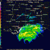
Well, if this thing doesn't make a last minute change, I'm toast!  The latest forecast means that the eye may pass over my house. My girlfriend lives 9 miles to the east, which is closer to Mobile Bay, so her place may get it worse than mine. One of my employees lives south of interstate 10, and that area was placed under a mandatory evacuation order by Governor Riley this afternoon. Lots of people getting out of the area here. Nerves are frazzled; saw a traffic accident on my way home from work. Anyway, here is the latest tracking chart. I put a yellow dot where I live:
The latest forecast means that the eye may pass over my house. My girlfriend lives 9 miles to the east, which is closer to Mobile Bay, so her place may get it worse than mine. One of my employees lives south of interstate 10, and that area was placed under a mandatory evacuation order by Governor Riley this afternoon. Lots of people getting out of the area here. Nerves are frazzled; saw a traffic accident on my way home from work. Anyway, here is the latest tracking chart. I put a yellow dot where I live: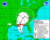
 Hey seriously though, youd better get out of there!
")
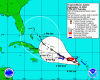


 I hope Ivan misses New Orleans.
 I-10 has become a one-way road out of N.O. and the I-110 is clogged to the point of people riding bicycles faster than traffic is moving.
![[pimp]](/images/smilies/pimp.gif "Pimp [pimp]")


")