stormbind said:
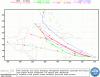
Are the lines in the previous graph predictions by competing sources? UKMET is the UK national meteorological prediction?

Yes, UKMET is the British model, which is one of the better ones at hurricane prediction. There are other mdels besides the ones on the graph.
Ivan is now a category 5 hurricane!
HURRICANE IVAN DISCUSSION NUMBER 28
NWS TPC/NATIONAL HURRICANE CENTER MIAMI FL
5 AM EDT THU SEP 09 2004
AIR FORCE RECON THIS MORNING HAS FOUND AN INTENSE HURRICANE IVAN.
THE CENTRAL PRESSURE OF 922 MB HAS DROPPED 15 MB IN THE PAST 7
HOURS...WHILE THE 700 MB FLIGHT-LEVEL WINDS HAVE INCREASED TO 154
KT...EQUAL TO 139 KT SURFACE WIND...TO THE NORTH AND NORTHEAST OF
THE CENTER ON TWO SEPARATE PASSES. IN ADDITION...AND EYEWALL
DROPSONDE RECORDED A WIND SPEED OF 175 KT AT ABOUT 630 FT ABOVE SEA
LEVEL. BASED ON THIS INFORMATION...
IVAN IS EASILY UPGRADED TO A
140-KT CATEGORY 5 HURRICANE. AS I WRITE...A NEW RECON REPORT
INDICATES AN EXTRAPOLATED PRESSURE OF 916 MB.
HURRICANE IVAN ADVISORY NUMBER 28
NWS TPC/NATIONAL HURRICANE CENTER MIAMI FL
5 AM AST THU SEP 09 2004
...IVAN REMAINS AN EXTREMELY DANGEROUS CATEGORY 5 HURRICANE AS IT
HEADS IN THE GENERAL DIRECTION OF JAMAICA...
A HURRICANE WARNING REMAINS IN EFFECT FOR ARUBA...BONAIRE...AND
CURACAO.
A HURRICANE WATCH AND A TROPICAL STORM WARNING REMAIN IN EFFECT FOR
THE GUAJIRA PENINSULA OF COLOMBIA...FOR THE ENTIRE NORTHERN
COAST OF VENEZUELA...AND FOR THE ENTIRE SOUTHWEST PENINSULA OF HAITI
FROM THE BORDER OF THE DOMINICAN REPUBLIC WESTWARD...INCLUDING PORT
AU PRINCE.
A HURRICANE WATCH REMAINS IN EFFECT FOR JAMAICA AND THE CAYMAN
ISLANDS. A HURRICANE WARNING WILL LIKELY BE REQUIRED FOR JAMAICA
LATER THIS MORNING.
A TROPICAL STORM WATCH REMAINS IN EFFECT FOR THE SOUTHWESTERN
COAST OF THE DOMINICAN REPUBLIC FROM SANTO DOMINGO WESTWARD TO
PEDERNALES. TROPICAL STORM WARNINGS MAY BE REQUIRED FOR A PORTION
OF THIS AREA LATER TODAY.
INTERESTS IN CENTRAL AND WESTERN CARIBBEAN SEA SHOULD CLOSELY
MONITOR THE PROGRESS OF DANGEROUS HURRICANE IVAN.
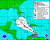
AT 5 AM AST...0900Z...THE CENTER OF HURRICANE IVAN WAS LOCATED
NEAR LATITUDE 13.9 NORTH...LONGITUDE 70.0 WEST OR ABOUT 535
MILES... 860 KM...EAST-SOUTHEAST OF KINGSTON JAMAICA.
IVAN IS MOVING TOWARD THE WEST-NORTHWEST NEAR 15 MPH
...24 KM/HR...AND THIS GENERAL MOTION IS EXPECTED TO CONTINUE FOR
THE NEXT 24 HOURS. ON THIS TRACK...THE CENTER OF IVAN SHOULD
REMAIN WELL TO THE NORTH OF ARUBA DURING THE NEXT SEVERAL
HOURS...AND THEN CONTINUE ON ROUTE TOWARD THE AREA NEAR JAMAICA.
RECENT REPORTS FROM AN AIR FORCE RESERVE HURRICANE HUNTER AIRCRAFT
INDICATE THAT MAXIMUM SUSTAINED WINDS REMAIN AT LEAST 160 MPH...255
KM/HR...WITH HIGHER GUSTS. THIS MAKES IVAN A RARE CATEGORY 5
HURRICANE ON THE SAFFIR-SIMPSON HURRICANE SCALE. ALTHOUGH SOME
FLUCTUATIONS IN STRENGTH ARE LIKELY...IVAN COULD STILL INTENSIFY A
LITTLE MORE THIS MORNING.


 .
. Now those are some real troopers. Marine Corps meteorologists.
 ")