I need your help with these maps

sDoFAAV.gif


You can pretty much make a map like this say whatever you want. In this case, I have done away with France and Germany, and installed in its rightful place mighty Lotharingia, natural hegemon of the European plains. So if White's circles correspond to any particular polities, all that tells us is that he has drawn them to be so.
Nah I don't think it is quit that easy. If I am not wrong the standard for the placement of circles is not familiarity, but how you get the biggest circles. And that this approach produces more familiar results than your in deed rather arbitrary alternative placement goes to show that it is not just coffee cup reading.
 
Nah I don't think it is quit that easy. If I am not wrong the standard for the placement of circles is not familiarity, but how you get the biggest circles. And that this approach produces more familiar results than your in deed rather arbitrary alternative placement goes to show that it is not just coffee cup reading.
What's non-arbitrary about "draw the biggest possible circles"?
 
Is this map posted by Winner in the first post supposed to show the Medieval state-building processes? In such case, I am not sure why its author is counting offshoots of some states, as separate states - why so many circles in France and Germany, considering that all of them were just offshoots of the Frankish Empire? Many of Italian states were also offshots. Venice was a late offshot of the Eastern Roman Empire, which gained independence from the original founder and established its own state. Duchy of Western Pomerania was an offshot of Poland (Poland expanded into tribes of Western Pomerania, bringing state administration and state organization to that area - later Polish governors became independent and established their own dynasty there). Etc., etc.

Most of Christian states in Northern Iberian Peninsula, were also just offshoots of either the Visigothic Kingdom or the Basque states. Precisely - offshoots of remnants of those states, which survived the Muslim conquest in remote northern regions. Thus I completely do not agree with such a large number of circles in the Iberian Peninsula. Why there are no circles in some areas where states indeed were formed - for example the Balkans, Scotland, Ireland?

Why there is a circle in Brittany, but not in Normandy?

The Duchy of Normandy can be considered in some way a new state, rather than a Frankish offshoot. But Brittany?

There shouldn't be a separate circle in what is now Slovakia. But in Moravia (Great Moravia) and in Bohemia (Czechs' state). In the Balkans a large number of Medieval states was established - Carantania (now Slovenia), Croatia, Serbia, Bulgaria, etc. Some of them lost independence very quickly (Carantania) but it doesn't change the fact, that the state-building processes took place there, as those states were not offshoots of previously existing states.

In territory of modern Poland, according to some historians, there was not 1 but 2 Early Medieval states - the Polans' state and the Vistulans' state.

The Vistulans' state (with the capital city in Cracow) was conquered by the Moravians' state, later regained independence, later was conquered by the Czechs' state, and finally became part of the Polans' state. But it can be marked as a separate circle, since the state-building process took place.

BTW - while France and Germany are clearly Frankish offshoots (West Francia, East Francia), the issue of Northern Italy is more complicated.

================================

So below is how I see this (without Balkans and Italy so far, because these two regions are quite a complicated mess). We can see the Frankish state and its expansion, Irish kingdoms, Anglo-Saxon kingdoms, Scotland, Wales, Normandy, Scandinavian states, Kievan Rus, Polabian Slavs (they created maybe not unified states, but strong chiefdoms / tribal confederations with many large urban settlements), Visigothic / Basque entities in Northern Iberia (pushed back there by the Muslim Invasion), Kievan Rus, Czechia, Moravia, Carantania, Polans' state, Vistulans' state, Lithuania (but it emerged in the 13th century), etc.

I forgot to add the Teutonic Order's state in Prussia (13th century) and the Livonian Order's state in Livonia (13th century), which later merged:

my_version.png
 
Domen's map is better.
 
What's non-arbitrary about "draw the biggest possible circles"?
The rationale would be something like that cultural/political entities try to minimize the length of their borders compared to the size of the entity, but want to cover the largest area possible. If you want to minimize the differences between any two people of the entity, yet want to form a powerful entity you end up with a circle as the best shape.
Uppi formulated it a bit cartoonish, akin to saying that clouds would rise when meeting a mountain because they "will try to get over a mountain". But the point has IMO merit or at least sounds plausible.
A better formulation would be that a small ratio of border size and area size simply favors the establishment of entities by tending to make social interaction and their control easier / more cohesive whereas areas which interrupt this process due to a lacking suitability to food production and/or mere movement lend themselves to serve as an interruption of the formation of those entities.
Say that's an accurate description of how polities form. (I don't think it is, really, not least because it assumes that all polities take the form of a modern territorial state, plainly untrue in the Medieval period, but for purposes of argument let's say that it is.) But that assumes you start with a centre of power, which attempts to build a cohesive territory around itself, and extends out to the greatest extent it is able to, while at the same time other centres of power attempt to do the same. What White is doing the opposite of that, drawing circles and insisting that a centre of power will naturally appear somewhere within it, because: reasons. So even, on its own terms, its a backasswards approach, and the fact that some of the circles correspond to some of the major Medieval polities (some major polities possess no circle, like Burgundy, some circles correspond to no particular polity, like "Germany") only seems to affirm my observation that you can make the map seem what you want.
 
As for Early Medieval Europe, we shouldn't forget how heavily forested it was. Especially outside of former Roman Empire's territories.

Below is a map showing the probable extent of forests in the 8th and the 9th centuries in much of Western Slavic lands - of course green-coloured areas marked in this map as forested were not totally uninhabited, but population density in these areas was much smaller than in white-coloured areas which were already reclaimed from nature. To illustrate the difference in population density - perhaps the green-coloured, heavily forested areas had a pop. density of some 1 - 3 people per km2, while areas already reclaimed from nature had a relatively high population density of 20 - 30 or even more people per km2. Overall, average pop. density at that time was about 4 - 8 people per km2, depending on region (Moravia-Bohemia and Polabian Slavs had a higher pop. density than Poland). Don't pay attention to this red boundary, nothing meaningful (probable extent of Eastern Obodrites - but counting Lubuszanie and Słupianie as Obodrites is controversial):

nmn488.jpg
 
Good point. Just because an area is relatively flat doesn't mean it's particularly well-suited to agricultural. Much of coastal Medieval Europe was wetland and much of the hinterland was forest or moorland, making the lovely big areas of "flat" ground on White's map very deceptive.
 
Exactly. Wetlands were also natural barriers for large-scale, dense human settlement (see the Pripet Marshes, for example).

All major west-east migration waves until the 20th century were bypassing the Pripet Marshes either from the north, or from the south:

800px-Marsh._Polissia.jpg
 
Natural borders do not really have to be extreme (in the sense of poising difficulty in passing through them for the tech level of the kingdoms around them) so as to be finalised in any sort of long-term civ expansion. For example the border of the Greek world was always the Danube (no settlement seems to ever have been north of that river, although obviously some were to the north in other areas, as in the Crimean peninsula).
The Danube was the border during Roman times, including the Byzantine Empire. Afaik there was never an interest to incorporate lands north of it. Not sure how much of it was heavily defended, but it is unrealistic to expect most of it to have been, given that the Byzantine Empire pretty much covered over 90% of the Danube as its border, and before it the unified Roman Empire included all of it in the same way...
 
So-called "natural borders" are always invented after the fact, though, to just an existing political, cultural or social reality. Major river-systems are a particular blatant case in point: in one place, they form the "natural" core of a state, in another, its "natural" frontier. It is "natural" that the Han should encounter the Yellow River as the font of civilisation, and "natural" that the Greeks should encounter the Danube is an impassable frontier between civilisation and barbarism.
 
Kyriakos said:
Afaik there was never an interest to incorporate lands north of it. Not sure how much of it was heavily defended, but it is unrealistic to expect most of it to have been, given that the Byzantine Empire pretty much covered over 90% of the Danube as its border

Most of the time the Byzantine Empire was so busy struggling to preserve areas south of the Danube under their control (and it was often going pretty badly for them, actually), that perhaps they didn't have time to try expanding north of this river. So the lack of northward expansion beyond the Danube was not really about lack of interest in doing so, but about problems in their own backyard. Add to this problems with preserving other parts of the Empire as well.

The Byzantines even lost control over their own capital city - Constantinople - to crusaders for more than 50 years (1204 - 1261).

Actually most of the Danube River was more often beyond Byzantine power, than within its extent.

First Bulgarian Empire (681-1018), then the Byzantines at the Danube (1018-1185), and then Second Bulgarian Empire (1185-1396).

If I count correctly, this is ca. 550 years of Bulgarian control over the Danube, and just ca. 170 years of Byzantine control.
 
True, but it also seems that a large river may seem far more logical to the foreign king (or warlord, as was often the case) to agree as a border, rather than an arbitrary position in the mainland :) Justinian didn't seem interested in going north of the Danube either, although he was obviously very keen to encircle all of the med sea as a Byzantine pond (and of course it was not viable in the long-run or even short-run).
 
Kyriakos said:
Justinian didn't seem interested in going north of the Danube either, although he was obviously very keen to encircle all of the med sea as a Byzantine pond (and of course it was not viable in the long-run or even short-run).

Justinian - being busy with turning the western part of the Med Sea into a Byzantine pond - let the Slavic hordes into the weakly defended Balkans.

So he actually could not prevent others from being interested in going south of the Danube (and doing so). While you would like him to go north! :p

When Belisarius with his army was busy conquering North Africa, Italy and Southern Iberia, Slavic tribes invaded and colonized the Balkans.

This aspect of Justinian's reign is often overlooked - and it gives him a black eye as a ruler. It shows that he failed in some aspects.
 
The Byz empire existed for a few aeons before 681, though (most count it as beginning with Constantine). Also the Bulgarian empires did not immediately control the Danubean border, and neither did they control all or most of it for most of their lifespan ;)
In fact the Bulgaria which came to exist again as a direct result of the fourth crusade, did not control Serbia or the rest of the 'yugoslavia' anyway. It was not even viable until the 1230s and the disaster of the Despotate of Epiros at Klokonitsa, which effectively meant that Bulgaria was the main power in the west of the old Empire (but like i said it never took over Serbian or other west-south-slav territory again).
 
The Byz empire existed for a few aeons before 681

Depends when is the end of the Eastern Roman Empire, and when is the beginning of the Byzantine Empire according to you.

Typically the moment when Greek replaced Latin as official language of the Empire is given as the Rome to Byzantine "switching" date.

Also the Bulgarian empires did not immediately control the Danubean border, and neither did they control all or most of it

This is true. But the Byzantine Empire also usually did not control the western part of the Danube.

That was controlled by the Ostrogoths, by the Huns, by the Avars, by the Serbians, by the Hungarians, etc., etc. Depending on period.
 
Well, regarding Justinian, i recall reading a review of a classic CivII scenario about the Justinian era, in which the reviewer said something along the lines of "[...] and then i took my Belissarius unit to Sicily and used it to grind everyone to dust" :D

It seems that Belissarios was indeed the greatest general of the empire, although some other notables also existed (eg Strategopoulos, with the rather apt name ;) ).
 
Domen said:
This is true. But the Byzantine Empire also usually did not control the western part of the Danube.

That was controlled by the Ostrogoths, by the Huns, by the Avars, by the Serbians, by the Hungarians, etc., etc. Depending on period.

And I forgot the Great Moravia and the Frankish Empire, each of whom also controlled the western part of the Danube River for some time.

===========================

Yes Belisarius was an excellent commander it seems.

In fact the Bulgaria which came to exist again as a direct result of the fourth crusade, did not control Serbia or the rest of the 'yugoslavia' anyway.

Serbia controlled itself for several hundred years, actually. :) So did Croatia (until it was merged with Hungary).

In some periods Serbia was a tributary of the Byzantine Empire, but still largely independent.

Bulgaria did not come into existence as a result of the fourth crusade, but rather only regained its independence at that time.

BTW - I can't think of a period, when Bulgaria existed and did not control the Danube Delta and the coast of the Black Sea in that area.

That's because the core of Bulgaria was always located to the south of the Danube River. During the Second Bulgarian Empire, it seems that they did not even control any territories north of the Danube (at that time there lived the nomadic Cumans and the Wallachians - ancestors of Romanians).

Before Cumans, there were also Pechenegs in areas to the north of the Danube. But maybe they lived under Bulgarian rules.

In 1211 Hungarian King Andrew II invited the Teutonic Order to the area called Burzenland (Land of Bors), near the Hungarian-Cuman border.

The purpose of inviting the Teutonic Order was of course to help the Hungarians in their fight against Pagan Cumans.

But in 1225 Hungarian King expelled the Teutonic Order from his lands, and that's why it was invited to Land of Chełmno in Northern Poland in 1228. :)

Wallachians somehow "disappear in the shadow of history" during that period. But it seems that they simply lived under Cuman and Hungarian rules.

=============================

BTW - the fourth crusade was in years 1202 - 1204, and Bulgaria actually regained its independence already in 1185.

So perhaps as the result of the fourth crusade it expanded farther into Byzantine lands. But it already existed before that crusade.
 
Domen said:
(...) During the Second Bulgarian Empire, it seems that they did not even control any territories north of the Danube (at that time there lived the nomadic Cumans and the Wallachians - ancestors of Romanians).

Before Cumans, there were also Pechenegs in areas to the north of the Danube. But maybe they lived under Bulgarian rules.

In 1211 Hungarian King Andrew II invited the Teutonic Order to the area called Burzenland (Land of Bors), near the Hungarian-Cuman border.

The purpose of inviting the Teutonic Order was of course to help the Hungarians in their fight against Pagan Cumans.

But in 1225 Hungarian King expelled the Teutonic Order from his lands, and that's why it was invited to Land of Chełmno in Northern Poland in 1228.

Wallachians somehow "disappear in the shadow of history" during that period. But it seems that they simply lived under Cuman and Hungarian rules.

In the map below is the Teutonic Order's state in Burzenland in 1224 (they already founded some castles and towns there since 1211):

I wonder what prospects for expansion it would have had, had it not been dismantled by king Andrew in 1225 ???

Cumans - just like Prussians - were also divided for many tribes. But I suppose conquering such nomadic people would be more difficult.

In the conquest of Prussians by the Teutonic Order crucial support role was played by European crusaders - mainly from German and Polish states.

Burzenland.png


I can already imagine the Battle of Southern Grunwald - Byzantine Empire (or maybe Hungary or Turks?) vs the Teutonic Order. :)

In alternative history, of course. Because in reality King Andrew ruined everything! :mad: :(

=============================================

Edit:

Let's move with this Teutonic Burzenland thing to a new thread:

http://forums.civfanatics.com/showthread.php?p=13008107#post13008107
 
(I wish certain people in this thread at least looked at the maps carefully before posting. You'll know whom I have in mind.)

Well a bit of an idea of plate tectonics, temperature/humidity and air circulation and this circle-concept should suffice for some first-glance geographical realism.
But if you wanted to be really good, you would probably need some knowledge about geology, sediments and so forth. And a good grasp on how all this shapes plant life and how all this then shapes animal life and at best how all this tends to shape population density....

And a supercomputer to model billions of years of geologic history ;) Complete realism is by definition unachievable, you can only approach it. What I meant is by no means that I am at all very good at it. I just try to avoid the most common idiocies I see in random fantasy maps ("I need a desert next to a swamp so that my hero can do X - why the hell not!" :crazyeye: )

sDoFAAV.gif


You can pretty much make a map like this say whatever you want. In this case, I have done away with France and Germany, and installed in its rightful place mighty Lotharingia, natural hegemon of the European plains. So if White's circles correspond to any particular polities, all that tells us is that he has drawn them to be so.

Sigh. The point of this thread is to deduce the method he used; obviously he wouldn't have bothered if they draw the circles at random. Already explained:

Nah I don't think it is quit that easy. If I am not wrong the standard for the placement of circles is not familiarity, but how you get the biggest circles. And that this approach produces more familiar results than your in deed rather arbitrary alternative placement goes to show that it is not just coffee cup reading.

What's non-arbitrary about "draw the biggest possible circles"?

Everything :rolleyes:

That's true in the European map, but not true of the American map. Really, it just makes no sense overall.

The American map is relatively nonsensical to anyone that lives here.

I believe the White guy is as American as it gets.

In particular, the Appalachian mountains are not any kind of natural barrier that divides kingdoms and I can't think of any reason you'd find a thousand petty Kingdoms in Maine and Vermont.

No? I'd say they're pretty similar to the mountains of Wales. You don't need Himalayas to create a region of fractured petty kingdoms (you don't need mountains at all, I might add - a large, thinly populated country with a lot of bogs and marshes and unfertile plains will also tend to produce a similar thing). In the end, each valley ends up having its own petty king, who occasionally conquers the neighbouring valleys to pronounce himself the high king, only to die and have it all split between his sons. Rinse and repeat.

On the other hand, other natural dividing points don't divide, so it's wrong in both ways.

What? :huh:

Good point. Just because an area is relatively flat doesn't mean it's particularly well-suited to agricultural. Much of coastal Medieval Europe was wetland and much of the hinterland was forest or moorland, making the lovely big areas of "flat" ground on White's map very deceptive.

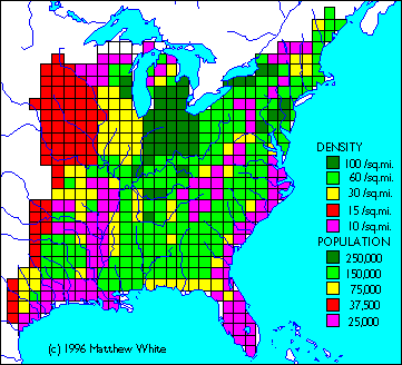
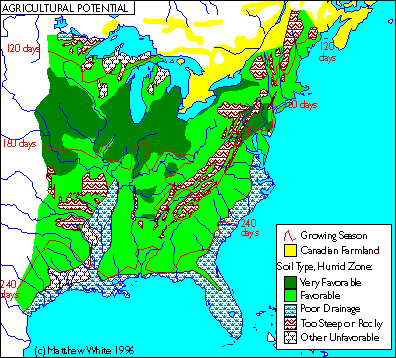
Coastal marshlands are shown on both maps. In the American one (the one White clearly put more effort into) shows the coastal marshlands in the American south as a major factor. He's got a map showing population density somewhere, which is pretty consistent with it.

pop-east.gif


soil.gif


As for Early Medieval Europe, we shouldn't forget how heavily forested it was. Especially outside of former Roman Empire's territories.

The "especially" part is important.

What White does in his project is to make a slightly tongue-in-cheek representation of America after the industrial civilization fell. The parallels with the fall of Rome abound.

Now, eastern US is now pretty deforested, pretty much like Roman-controlled Europe was (not to such extent though due to the much lower Roman tech-level). Following the collapse of modern civilization and the loss of 4/5ths of the US population to famine, disease and war, some reforestation would have occurred, especially in those area which are too difficult and/or dangerous to till.

The European map probably refers specifically to high/late Middle Ages, since that's roughly the tech level of White's medieval America.

---

Overall, I am dismayed by the level of hostility some people show to something so harmless - nobody is making this a new textbook rule or pretends to have a "skeleton key to history". It's just an interesting way of looking at things and I am interested in it only because it might be useful outside the field of history. There's no need to unleash the full academic hair-splitting fury against it. Practically anything can be ground into dust in this way and it is not helpful.

---

@Kyriakos, Domen

I appreciates inputs ON TOPIC. If you want to discuss Byzantine Empire and/or Poland, please do it somewhere ELSE. Thank you.
 
Back
Top Bottom