amadeus
rad thibodeaux-xs
The GOP holds the governor's office in Minnesota, not the DFL.
Here is a map of the true red and blue states, based on every measure of classification found in the red/blue states wiki article combined.
1) Elected the same party in the electoral college in all four of the most recent presidential elections
2) Average margin of victory in the presidential election is above 5% for the same party over the last five presidential elections.
3) Both current senators are from the same party
4) Same party holds the U.S. state legislative upper house and lower house majority (Nebraska's unicamberal system is irrelevant because is fails a different criteria)
5) Same party hold the governor office
6) Same party holds at least 60% of the house of representatives from its state
7) Same party is listed in the "Current classification" section at the bottom of the article.

Blue states: Washington, Oregon,Minnesota,Wisconsin, Illinois, New York, Maryland, New Jersey, Massachusetts, Rhode Island
Red states: Utah, Texas, South Carolina

Didn't New Jersey just elect a republican governor as well?
Just checked then, and yes, but he doesn't take office until mid January, so I think I'll keep the map as is.
Map with party affiliations


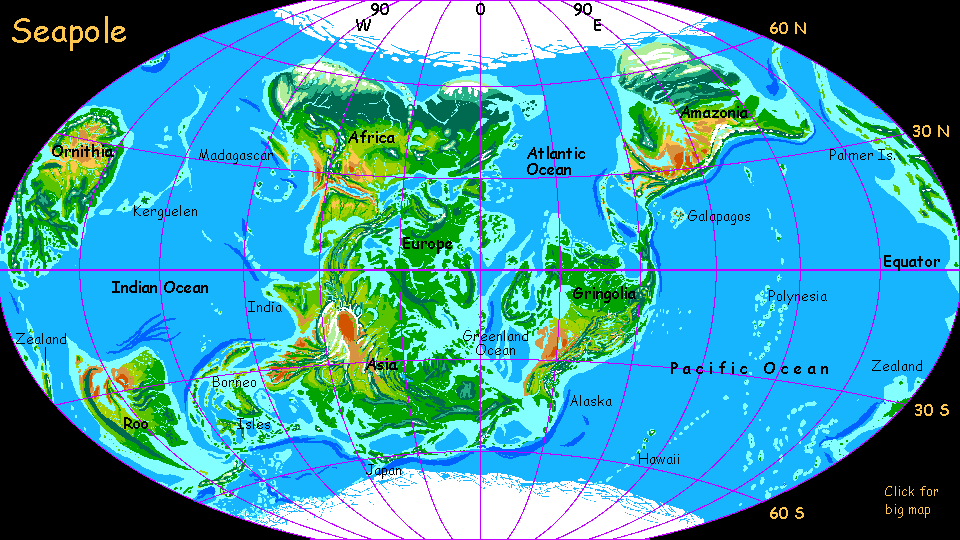
GLOBAL CLIMATE AND SEA LEVEL
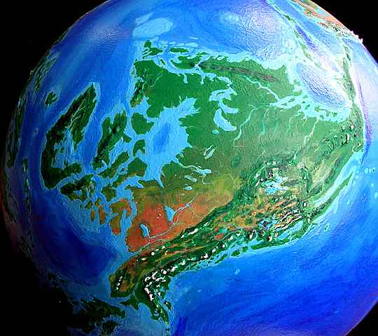
As an experiment, I took an Earth globe off its stand and tilted it until both poles were oceanic, like our Arctic. That wasn't easy! With our current geography, nearly all possible axes have one wet pole and one dry (quite by chance--in many geological eras, it wasn't so). I only found two "wet" orientations--this one, with poles in the South Atlantic and off Japan, or poles in the Arabian Sea and south of Mexico. Here's an orbital shot of the "north" pole I chose, with the icy mountains of Brazil at upper left and the cool boreal forests of Africa on the right.
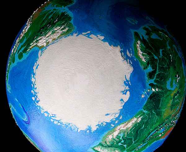
With no land near either pole, there's no Antarctic ice dome, not even a Greenland. With almost none of the world's water locked up in thick ice, sea levels are 90 meters higher (nearly 300'). The weight of that extra water on coasts and continental shelves presses them down, just as glaciers during our Ice Ages depress the land beneath them. This slightly exaggerates the coastal flooding (though continental interiors bulge up a bit to compensate)--the result is an effective sea level rise in most places of about 100 meters (328'). Sound like a lot? It is, and we may learn that the hard way in the next few generations--see Dubia, a model of Earth 1000 years from now, after full polar meltdown.
World climate is much warmer and wetter, especially toward the poles. While they're still icy, temperatures above 60 north are more Alaskan than Antarctic or even Greenland. In severe winters, this northern ice pack occasionally forms a bridge between Brazil and Africa; in hot summers, the pack may briefly break up into bergs, which our Arctic pack never has (so far; it may soon). My point is that sea ice is thin and changeable compared to land glaciation. This icepack looks impressive, but Seapole has only 1-2% of Earth's ice.
What happens at lower latitudes without icecaps breathing down their neck? The high sea levels dominate climate. Instead of fertile coasts but harsh continental interiors, nearly all of Seapole has maritime climate--for the sea is everywhere. Perhaps 20% less land than Earth! Rainforests and savannas; few deserts. A warm, flooded, jungly world.
Here's a map showing the tilt, the flooded coast and new inland seas; it'll help orient you, too. Or disorient you! Does it all look distorted and moved around, like a map of the breakup of Pangea? It's not continental drift--these are our continents (a bit flooded and damp, but basically undamaged) in exactly the same layout! But mapping round Earth on a flat sheet distorts it terribly--you're just used to the conventional map's polar distortions. This map's just as accurate--but its distortion's unfamiliar. Visual habits are powerful!
The meridians run from the new poles, of course, but the Prime Meridian (the centerline, longitude zero) is still Greenwich, England. Yep, that little green archipelago just above dead center is England, upside down and flooded. That's Scandinavia beneath it and the similar big island to the east is Greenland--rightly named at last! I renamed a few continents--having North America south of South America seemed a recipe for confusion, for example, and Australia and Antarctica's names are just Latinized terms for their Earthly locations.
The inland seas do resemble ancient times. But it's not as hot as the Age of Dinos, and the cause is different. In the Cretaceous the heat came from sky-high carbon dioxide levels, but Seapole's warmth isn't from CO2--it's pure geography. In fact, the biggest flaw in this model is that such lush greenery all over the (remaining) land surface might lock up so much carbon that C02 levels would be forced down, cooling Seapole till glaciers spread in various highlands, lowering sea levels and shrinking the jungles again... Gaia or no Gaia, world climate may indeed be rather homeostatic (self-regulating). But that's not proven, so here, I've let the melting run its course--CO2 levels are much like our own, yet the climate's nearly ice-free. I repeat: the changes you see are caused by tilting the earth alone--no greenhouse gas was added. CO2 from an industrial civilization like ours would make it even steamier.
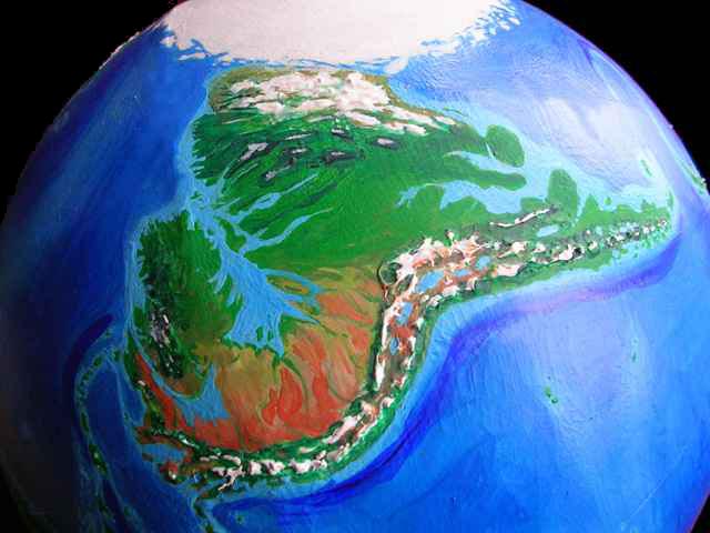
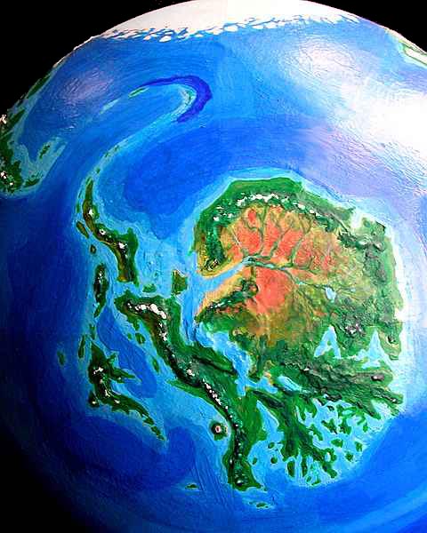
For clarity, I've removed the cloud cover. Earth has changed so much it'll be hard to recognize, even without clouds blocking the view (to right: Africa above, Asia below, Europe in shadow at right). North is always up, except for polar views. Oh--these orbital photos aren't digital modeling but shots of a real globe tilted and repainted to fit the new sea level and climate. So don't email me asking to borrow my dataset--it's my brain. I've learned from painful experience: never loan your brain.
When charting Seapole's coastline, I made a few exceptions to the 100-meter contour. I didn't enlarge Baffin Bay much--in our world, the area's still depressed from its ice burden ten thousand years ago. But Seapole is warmer, and is unlikely to have had any recent ice ages, so Baffin Bay might be small, or not exist at all. Yet with sea levels so much higher, some of the Baffin Shield would certainly flood. But how much? In the end I just marked a modest sea-incursion and gave up. I left the Great Lakes alone, too, though they're largely artifacts of the Ice Age. I don't know what their basins looked like before the ice, and I'm not sure anyone does. For the same reasons, I've shown Greenland's inland sea somewhat smaller than the 100-meter sea rise would justify. But there might be no inland sea at all, but a near-Amazonian basin dotted with lakes.
On the other hand, for the Baltic Sea, I marked the sea-rise in full, just for shock value--it turns "continental" Europe into a maritime peninsula little wider than France, all the way to the Urals. Maybe I should reconnect Scandinavia to Europe and drain the Polish Gulf, but aside from creating a wider, more Amazonian rainforest there, and perhaps a drier Caspian/Caucasian region to the west, I don't think it'd matter much except to the locals.
The huge gulfs of Siberia, on the other hand, would almost certainly exist, and affect climate far inland--in our world these lands weren't heavily glaciated and aren't rebounding much, so in a tropical world, they'd likely be about the same altitude--that is, low enough to flood.
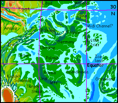
Antarctica is the least certain, of course. Our soundings have (crudely) mapped a complex land groaning under two or three miles of ice. Without that burden, Seapole's Antarctica would ride higher, and thus be larger--perhaps quite a bit larger. For simplicity, I declared that the first centuries of rebound (it's slow, taking thousands of years) would be roughly canceled by the higher sea level, so I could use what data we have without further guesswork... but that's probably wrong. The land might well be even larger, the islands more numerous--a huge, intricate, unpredictable continent, the most fascinating of them all. It just looks like a turkey.
Western / Eastern Europe problem solved


")
