Altered maps

Status
Not open for further replies.
I found this map very interesting:

old_europe.jpg


It's the european currency's before the euro.

That map is pretty cool however the bolded part above makes me cry.

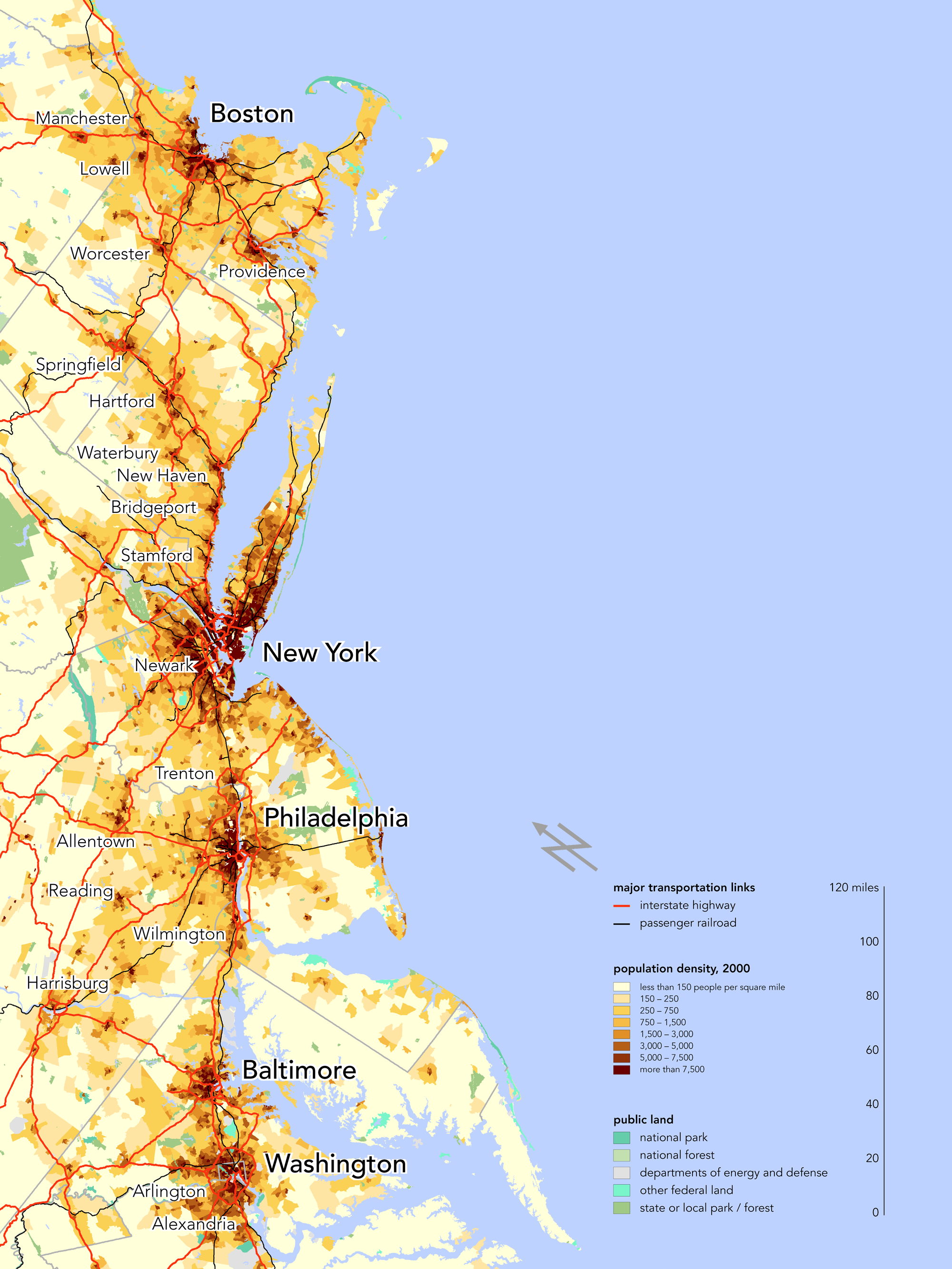
Boswash.png


I like this pic. Not really altered, but has an altered point of view.

Wow. At first glance I thought it had to be altered.
 
More interesting Maps:

1207koreaelectricitygrikf0.jpg


Shows the vast difference of development between the korea's. North Korea is almost barely visible one the night sky with only Pyongyang as a source of light.

14-lakechad.jpg

Lake Chad's decreasing size

Weather of Erope in 2071:
climatemap.jpg

Description:
This map shows which climate European cities can expect 64 years in the future:

London’s climate will resemble that of the Portuguese coast;
Paris weather will resemble that of the Extremadura, in the interior of the Iberian peninsula;
Stockholm and Oslo are a bit further to the north, close together and close to Barcelona;
Barcelona itself will meteorologically migrate to northern Morocco;
while Berlin will situate itself weather-wise in the Algerian hinterlands of Kabylia;
Istanbul, the largest Turkish city, will move to the southern coast of that country;
and will be joined there by Rome, as its present-day climate will prove all but eternal;
Helsinki’s weather will resemble that of central Europe, southern Poland to be exact;
and finally, Saint Petersburg will come to feel like Belarus - although I’m not sure that’s much of an improvement.
 
I currently am, going to college in DC, but where I live isn't in any of the 10 megapolitan areas which holds 62% of the US population and 76 of the top 100 metropolitan areas(BosWash is the largest with 16% of the total US population alone). I'm from Albany, NY btw - 57th largest metropolitan area.
 
And I at the bottom, in Alexandria.

And I'm in the middle, in New York.

I currently am, going to college in DC, but where I live isn't in any of the 10 megapolitan areas which holds 62% of the US population and 76 of the top 100 metropolitan areas(BosWash is the largest with 16% of the total US population alone). I'm from Albany, NY btw - 57th largest metropolitan area.

I live in Albany right now, I go to SUNY Albany
 
The political situation in my latest C3C game. I'm Persia, the brown, and I included the territories of my chief "rivals;" which basically means nations that I actually care exist. There are something like 25 civs on the map, but you could add together most of their scores and still not equal mine, and they're pretty much a whole tech era behind. The nations shown are the ones who roughly keep pace with one another; collectively, we just entered the Modern Era. I and without question the world power. At this point, I just need to finish the UN so I can shut down that stupid victory condition, and I've effectively bagged my fourth Cultural Victory in this scenario (DYP-RAR on a 362-325 world map).

 
WTH would northern Dobrogea secede from Romania? :p I've never seen the slightest push in that direction by anybody ever! Who would want that? Romanians are 92% of the population there. :p
And why wouldn't northern Italy secede from the rest, and only the eastern parts?
Why would Crete secede from Greece? And what's that tiny brown point in northern Greece?

Just nitpicking at the very accurate map of a continent that doesn't exist. :) I know. Just having fun here like everyone else. :D

For Romania, blame the map i was copying off of.

Crete i through in there for fun. And the tiny brown point in greece is like Aromania or something.

What are these 4 little states in Northern Germany? Especially the dark green one? I might just end up in there, but I want to be in the brown one, where I belong :( .

East and North Frisia. two of them are North Frisia, it's a mistake with the colouring, there actually 1 state. The Dark Green one was my sad attempt at Saxony.

why is italy whole? also, germany isnt nearly split up enough. (and neither is austria.)

I didn't know what to do to Italy, and my maps i had didn't specify much about it. I thought i was being mean to Germany enough so i didn't do more, and i really do not know what to do with Austria.
 
I didn't know what to do to Italy, and my maps i had didn't specify much about it. I thought i was being mean to Germany enough so i didn't do more, and i really do not know what to do with Austria.

Separate Sicily, Naples, Lombardy, and Savoy.
 
Status
Not open for further replies.
Back
Top Bottom