Lokki242
Emperor
Maybe those unit types would always be "rushable" as well?
Last edited:
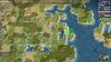
Could you maybe achieve this by creating "straight" as a terrain type with this graphics, and leaving coast with the old graphics?- It will replace all isthmuses, so the Sinai and Panama isthmuses will be disconnected as well.
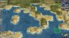
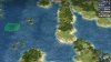
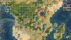
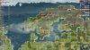
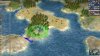
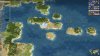
Some more experimentation with the elevation system of Planetfall. And also with peaks as terrain features.
Spoiler :

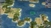
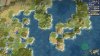
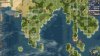
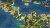
Bad news. It seems that it is impossible to have both isthmuses and straits. Or at least in a controlled way.
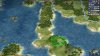
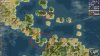
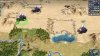
The heightmap of the coast controls the height of the tile. As you can see in the screenshots of my previous posts, I can edit them succesfully. There are several heightmaps for different terrains. For the diagonal coastal tiles have 6 different heightmaps, which by default all create an isthmus. They only have some small variation how the isthmus looks like. I assume this is to get some variety.
The problem is that I cannot control which of the heightmap is used. It seems to be hidden in the exe. I can change half of the heightmaps to become straits. The result will be that about half of the diagonal water tiles become straits and the other half remain isthmuses. But as said, I cannot control which ones.
I tried to create a new dummy coast land type with an unique set of heigthmaps, but I cannot link them to the new heightmaps as this seems to be in the exe too. The new land type will use the heightmaps of the default coast type.
Spoiler :Firaxis, release the source of the exe!
https://forums.civfanatics.com/threads/plan-to-get-the-source-code-for-the-exe.607803/
What if we just don't use diagonal tiles when we don't want a strait? The new map adds a lot of new tiles, I'd imagine that with a lot of finagling it may be possible.
I kinda wanted to get back to this and restart an initiative based around my proposed plan (developing an improved exe under closed source), I even have a roadmap written up and everything.Spoiler :Firaxis, release the source of the exe!
https://forums.civfanatics.com/threads/plan-to-get-the-source-code-for-the-exe.607803/
Do I understand the proposal correctly?
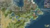
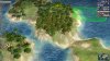
1) Change height maps so diagonal connections become straits instead of isthmuses
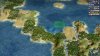
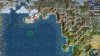
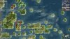
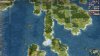
2) Create a new dummy terrain that is otherwise identical to Coast but has a different height (?) which we can put everywhere we want to prevent straits from forming, indicated by ice in the above screenshots
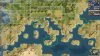
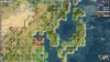
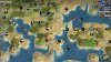
We have lots of examples were we want to force isthmuses back into the map, so can we please take a step back and collect where we actually want diagonal straits? Right now all I can think of is Sardinia/Corsica, Sicily/Italy, Zealand/Scania for that one proposal where they're connected, maybe Tierra del Fuego, am I missing something? None of these seem all that important to have, and I would actually be opposed to cutting off Sicily from Italy. In general removing land connections and making naval access mandatory will only make the game worse because it will make life harder for the AI.
Honestly if we are experimenting with the path connection logic I would be more interested in going in the other direction, finding a way to enable crossing a genuine water tile without ships. Places like Gibraltar, the Channel or Malacca would be vastly improved for the AI (and human convenience) if we could find away to allow units to pass through but not end their turn on a water tile they or a friendly power culturally controls.
I kinda wanted to get back to this and restart an initiative based around my proposed plan (developing an improved exe under closed source), I even have a roadmap written up and everything.