- Home
- Forums
- CIVILIZATION IV
- Civ4 - Creation & Customization
- Civ4 - Project & Mod Development
- Civ4 - Rhye's and Fall of Civilization
- Rhye's and Fall - Dawn of Civilization
You are using an out of date browser. It may not display this or other websites correctly.
You should upgrade or use an alternative browser.
You should upgrade or use an alternative browser.
[Development] Alternative Map during 1.17
- Thread starter Leoreth
- Start date
Krieger-FS
Warlord
Perhaps we could use tropical woodland for the feature?
Also, if we want to use distinct names for terrain and features, we have to change one of the two marshes. The terrain could be named as wetland, while marsh is maintained for the feature.
Also, if we want to use distinct names for terrain and features, we have to change one of the two marshes. The terrain could be named as wetland, while marsh is maintained for the feature.
FraggleJock
Warlord
- Joined
- Jun 25, 2017
- Messages
- 143
Why out of the salt flats? You mean moving the course 1E? From a map the Okavango delta looks clearly separate from the salt flats.
Purely Aestheitc, I thought the river catchment graphic looks quite nice when overlaid on the saltpan terrain. Which really poor terrain is which is a moot point gameplay mechanically it's a hard sell to work a trash tile instead of have a specialist.
https://upload.wikimedia.org/wikipedia/commons/8/86/Okavango_River_Basin_map.png
this also suggests that the saltpans on the map may only partly represent the pans in the area
Last edited:
Oblivionyx
Warlord
- Joined
- Sep 10, 2018
- Messages
- 173
What about Prairie? Though it's regional too, since it refers to grasslands in North America.
I’m against prairie for translation reasons, as it is the current French word for grasslands.
I was thinking of something like Savanna + Savanna woodland, or Savanna grassland + Savanna.
Can the marsh terrain and feature be separate from one another? If yes, it might be a good idea to give them distinct names too. Fortunately there is no shortage of synonyms here. Wetland for the terrain sounds good.
This is the first time I am seeing these salt pans, and "deception pan" does not return many authoritative results. If you look here:Purely Aestheitc, I thought the river catchment graphic looks quite nice when overlaid on the saltpan terrain. Which really poor terrain is which is a moot point gameplay mechanically it's a hard sell to work a trash tile instead of have a specialist.
https://upload.wikimedia.org/wikipedia/commons/8/86/Okavango_River_Basin_map.png
this also suggests that the saltpans on the map may only partly represent the pans in the area
Spoiler :

You have the Etosha salt pan in Namibia and the Makgadikgari salt pans in eastern Botswana that are significant enough for inclusion, with the Okavango delta clearly separate to the west of the latter.
Besides Steb's objection, the current Savanna terrain is specifically for tropical savannas, for which I have never seen prairie being used. North American prairies are more often plains or steppe in the game.What about Prairie? Though it's regional too, since it refers to grasslands in North America.
Last edited:
merijn_v1
Black Belt

Really nice. If you still want to improve on it, I would put the bamboo stalks in a cluster very slightly further apart, and increase the number of bamboo clusters (maybe some with fewer stalks?) compared to trees.
Honestly, I'd just go with woodland.Do you know of any non-regional words for the savanna terrain that doesn't have the same name as the savanna feature, or vice versa?
Also, everyone. Africa looks fantastic.
I agree! Honestly Africa mostly took me so long because there were so many different suggestions that I had to pick from and combine with my own ideas.
As a slight contradiction to what I wrote above, something that hasn't been covered much for Africa is resources (outside of Egypt, Ethiopia, Mali). It's not that important right away because no civs actually live there, and we can divert more attention to that later on. But if anyone wants to review that there's still room for improvement I think.
As a slight contradiction to what I wrote above, something that hasn't been covered much for Africa is resources (outside of Egypt, Ethiopia, Mali). It's not that important right away because no civs actually live there, and we can divert more attention to that later on. But if anyone wants to review that there's still room for improvement I think.
New update, this time as a complete gallery walk:

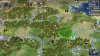
I used a river source as the Okavango delta instead of a river mouth, which looks a lot more like the real life delta. Unfortunately this means the river flows upstream for three tiles, because if river sections with different directions meet at 90 degrees they turn out like this:

It's not optimal to have the river flow upstream for such a long stretch, but it's also hard to notice and I still prefer the nicer looking delta.

The plains tile in Styria has been changed to a forested hill.

When looking up copper producing regions in the Bronze Age, Spain came up a lot as a significant producer of copper and tin, which led to the wealth of the city of Tartessos there (which would be on the tile marked as Sevilla). I moved the Olive 1W to free this tile both for Tartessos and Sevilla, then created a hill with copper 1N of it to represent the Sierra Morena, which was the most significant source of copper in southern Iberia. By the way, I only include some city markers on these screenshots for context of the cities I had in mind while doing this.

More semidesert in inner Tunisia, moved the sheep to make founding a city on that location to grab salt and wheat less appealing and opening Tacape/Gabes instead.

After considering it three times, I was finally convinced to add the Sparta tile. Copper in the Peloponnese is not only useful from a game design perspective, but also historical, and probably important for the historical development of the Mycenean/Greek civilisation.

- semidesert in Transjordan
- added stone near Jerusalem
- moved dye south to be near Tyre, I think this was kind of lost in the shuffle when the enlarged map was created because I am very sure it is meant to be Tyrian purple
- moved olives to open the Damascus tile
- moved sheep 1W
- added iron near Damascus
- moved opium 1W to free the Niniveh tile

No changes in this screenshot, just providing it for context for the city locations.
Spoiler :
I used a river source as the Okavango delta instead of a river mouth, which looks a lot more like the real life delta. Unfortunately this means the river flows upstream for three tiles, because if river sections with different directions meet at 90 degrees they turn out like this:
Spoiler :
It's not optimal to have the river flow upstream for such a long stretch, but it's also hard to notice and I still prefer the nicer looking delta.
Spoiler :
The plains tile in Styria has been changed to a forested hill.
Spoiler :
When looking up copper producing regions in the Bronze Age, Spain came up a lot as a significant producer of copper and tin, which led to the wealth of the city of Tartessos there (which would be on the tile marked as Sevilla). I moved the Olive 1W to free this tile both for Tartessos and Sevilla, then created a hill with copper 1N of it to represent the Sierra Morena, which was the most significant source of copper in southern Iberia. By the way, I only include some city markers on these screenshots for context of the cities I had in mind while doing this.
Spoiler :
More semidesert in inner Tunisia, moved the sheep to make founding a city on that location to grab salt and wheat less appealing and opening Tacape/Gabes instead.
Spoiler :
After considering it three times, I was finally convinced to add the Sparta tile. Copper in the Peloponnese is not only useful from a game design perspective, but also historical, and probably important for the historical development of the Mycenean/Greek civilisation.
Spoiler :
- semidesert in Transjordan
- added stone near Jerusalem
- moved dye south to be near Tyre, I think this was kind of lost in the shuffle when the enlarged map was created because I am very sure it is meant to be Tyrian purple
- moved olives to open the Damascus tile
- moved sheep 1W
- added iron near Damascus
- moved opium 1W to free the Niniveh tile
Spoiler :
No changes in this screenshot, just providing it for context for the city locations.
This wide Aegean Sea is screaming for a full land tile island somewhere... If not an isolated island in the middle, how about Rhodes 1 SW of the Anatolia marble and therefore connected to land? That way it could easily be settled, we’d be able to see the colossus in the correct location for the first time.
Also, the Okavango delta looks really nice, but I think I preferred the river mouth. For the river flow issue you mentioned, but also because it’s more distinctive. That river source pattern can be seen at a couple of places in the same screenshot, and we shouldn’t think of them as deltas.
Also, the Okavango delta looks really nice, but I think I preferred the river mouth. For the river flow issue you mentioned, but also because it’s more distinctive. That river source pattern can be seen at a couple of places in the same screenshot, and we shouldn’t think of them as deltas.
New update:

- added gems in Burma
- added rice in the Mekong delta
- added iron in Vietnam

- added stone in Punjab
- moved salt from Punjab to the salt flats in Sindh
- added ivory in the Ganges plain

- reduced the size of Tamil Nadu by one row, I think this both gives India a more accurate shape and brings it more in line with Sumatra and the Malay peninsula
- changed parts of Bengal to savanna
- removed gold
- added crab near Mumbai/Goa
- moved cow south to be in reach of Mumbai
- added islands between India and Ceylon
- replaced coal north of Nagpur with copper
- added coal and iron near Visakhapatnam

Added Savanna in northern Australia.
Spoiler :
- added gems in Burma
- added rice in the Mekong delta
- added iron in Vietnam
Spoiler :
- added stone in Punjab
- moved salt from Punjab to the salt flats in Sindh
- added ivory in the Ganges plain
Spoiler :
- reduced the size of Tamil Nadu by one row, I think this both gives India a more accurate shape and brings it more in line with Sumatra and the Malay peninsula
- changed parts of Bengal to savanna
- removed gold
- added crab near Mumbai/Goa
- moved cow south to be in reach of Mumbai
- added islands between India and Ceylon
- replaced coal north of Nagpur with copper
- added coal and iron near Visakhapatnam
Spoiler :
Added Savanna in northern Australia.
merijn_v1
Black Belt
I thought of Walrus Ivory being a possible candidate for a regional variant of Ivory. But then I remembered that Elephants are required for War Elephants and it makes no sense that Walruses enable War Elephants.
1SDANi
The Fading Memory
- Joined
- Oct 27, 2014
- Messages
- 3,079
War Walruses FTWI thought of Walrus Ivory being a possible candidate for a regional variant of Ivory. But then I remembered that Elephants are required for War Elephants and it makes no sense that Walruses enable War Elephants.
Enyavar
Prince
- Joined
- May 16, 2015
- Messages
- 517
The map development is great and I can't think of much I can contribute.
I have read it somewhere in this thread and can't claim it was my idea, but I second it: Dye could be a sea-also resource, like oil. That could be applied to dyes in the mediterranean. I think that at least the dyes in Algier, Tyrus and Egypt would be snail-dye, i.e. sea-based.
Furthermore, most natural dye resources should eventually die out in favor for industrial dye produced in [chemical industry] buildings. Possibly, the mediterranean snail resources would become extinct at a random date between 1200 and 1500, making dye a resource highly sought after (and also lower the importance of Northern Africa, just like when Ivory is removed there). The first land-based dye resources (Indigo) would be randomly removed as more and more civs discover [Chemistry] and can build some [chemical industry] building that is able to provide dye on demand, and only few natural dye resources remain for the end game.
How can I access the maps of 600 AD or 1700 AD in the world builder? In the map-development version, I can start a game as Egypt in 3000BC, then enter WB, but when I went to "Private Maps" to load the 1700 scenario, the game just crashes. When I start a 1700 scenario as Prussia, it loads the old 1.16 map.
So I can't see any of the later-game resource spawns (Banana in Africa and South America, Cows and Horses in the Americas, and so on).
For the late-game resource distribution, my workaround would be to look up every instance in the Resource.py file, and then manually place it on the map to see what is intended. Is the Resource.py up to date?
1SDANi
The Fading Memory
- Joined
- Oct 27, 2014
- Messages
- 3,079
The map development is great and I can't think of much I can contribute.
I have read it somewhere in this thread and can't claim it was my idea, but I second it: Dye could be a sea-also resource, like oil. That could be applied to dyes in the mediterranean. I think that at least the dyes in Algier, Tyrus and Egypt would be snail-dye, i.e. sea-based
Technically it was in the Map Suggestions thread.
Wait, would sea snails be better represented as a coastal resource improved by Fishing Boats, or a land resource improved by a plantation?
merijn_v1
Black Belt
How can I access the maps of 600 AD or 1700 AD in the world builder? In the map-development version, I can start a game as Egypt in 3000BC, then enter WB, but when I went to "Private Maps" to load the 1700 scenario, the game just crashes. When I start a 1700 scenario as Prussia, it loads the old 1.16 map.
So I can't see any of the later-game resource spawns (Banana in Africa and South America, Cows and Horses in the Americas, and so on).
They are not ready yet, because the final design of the map is not yet fully finished. It is a lot easier to apply changes to just one map and copy that map in the end than to apply the same change 3 times. And doing the same thing 3 times can easily cause inconsistencies between maps. Copying from the 3000 BC map in the end will make sure the maps are the same.
Oblivionyx
Warlord
- Joined
- Sep 10, 2018
- Messages
- 173
Now Crete will be a no-man's land again since the wine is reachable from Sparta. 
Similar threads
- Replies
- 27
- Views
- 5K
- Replies
- 735
- Views
- 103K
- Replies
- 7
- Views
- 2K
- Replies
- 34
- Views
- 10K