All right, here's my first halting efforts to contribute to the map.
")
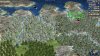
Specifically, I wanted to adjust the region I'm most familiar with: the Pacific Northwest, in North America.
Specifically, the Puget Sound used to be a two-tile coast feature: I changed it to a single water tile to represent the San Juan Islands, while the main part of the Puget Sound (that connects to Seattle and Olympia) is thin enough to be depicted as a river, as is the Strait of Juan de Fuca. (I also added in a river east of Seattle, to represent the massive complex of rivers and waterways that flow from the east and connect to the Puget Sound, including Lake Union, Lake Washington, Lake Sammamish, as well as the Snohomish and Duwamish Rivers).
I also added a mountain tile west of the Puget Sound to depict the Olympia Mountains, and covered it with a rainforest since that region is the only temperate rainforest in the world. (We could turn the tile into a hill, since people do live there and the mountain range is only part of the Olympic Peninsula, but the mountains are pretty notable, and if it's a mountain than the rainforest can't be removed by workers).
This allowed me to file in a few tiles south of the Olympia Mountains to represent the Pacific Coast, providing a more accurate 'bend' in the Columbia River (it veers north before reaching the Pacific) and adding the Willamette River that flows from Oregon to the Columbia River. Unfortunately, Oregon isn't tall enough to provide space for each of Portland/Salem/Eugene, and while Salem is the capital of the state, Eugene is comparable in size and a better match for the location.
I also moved the mountain tile north of the Columbia to more accurately represent Mt. Rainier, the most prominent mountain in the region. Mt. St. Helens is probably more famous for the volcano, but Mt. Rainier is also a volcano with regular (every ~400 year) eruptions, and more important to the history of the region.
I didn't change any of the resource distribution -- I just wanted to get the geography of the region clear and approved before I kept plugging away.