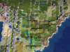
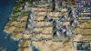
Moved the Pilcomayo, still good I think. Shape is different but reflects that West is larger than the East. Added the wheat (W) on the eastern floodplain, moved the corn one up because Asuncion (the assumed canonical city in Paraguay) would be crazy populated otherwise, also I just prefer not to represent 4 resources in a straight line ... but maybe the tobacco will be moved as well, not sure if I put that there or someone else but I don't know the justification.I'd shift the Pilcomayo river down a bit, so Paraguay includes the tile immediately south of the cow. If the Chaco is going to have a swamp, it should be this tile, rather than the tile north of the cow (there's a very small sliver of the Pantanal wetlands within Paraguay's border, but so small it's hardly worth the mention). The other tiles, including the cow and at least one tile east of the central Paraguay) should be floodplains. (Don't forget to add a wheat tile as well, perhaps on the floodplain east of the river).
Hills under all the forests in Paraguay but not the eastern floodplain where wheat is. Changed the mountains in Brazil to hills.I'm not able to get a good depth perception, so I can't tell if you raised any of the Paranena region as hills. There should be a entire range of hills connecting to the those mountains in southern Brazil. (...Checking the map of Brazil, I don't see any mountains or mountain ranges supposed to be on that tile. Are they supposed to represent the Mantiquiera Mountains? If so, they should be closer to Sao Paolo/Rio de Janeiro).
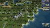
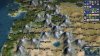
Added uranium (U) which would likely end up being used by Brazil anyway.As far as mining resources, the mineral industry of Paraguay is so minor I don't think it deserves much of one. There is a uranium deposit in Yuty, which could go on the far southeastern corner tile of the country. That would add a bit of commerce without much extra production, which should be fine.
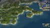
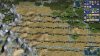
I went ahead and assumed you meant marshes not floodplains. And interpreted that to mean take out all the marshes in Northern Argentina except the two you suggested on the border with Paraguay. I added two flood plains (FP) and changed one tile to grasslands (G) and a couple of tiles I'd marked as steppe back to plains.Unrelated to Paraguay, but I did a bit of research on the Parana river in Argentina, and I really don't think there should be nearly as many floodplains as currently represented. There is one major wetland near the border with Paraguay -- that's the Ibera Wetlands in Corrientes, which can be represented by a two-tile swamp centered on the current tobacco tile + the current swamp tile immediately to its west. Everything else should be plains or grasslands (inland plains in the west, grasslands along the river), with the exception of one or two tiles at the Parana Delta (the mouth of the Rio de la Plata) which should be a grassland/floodplain.
Oh and whoever knows, I've been meaning to ask. Is there a way to get rid of the artefacts from the map when you remove marshes or you change from mountains/hills/plains/ocean?