stormogulen
Chieftain
- Joined
- Jul 6, 2019
- Messages
- 65
Now, some further attempts on Scandinavia (mostly terrain changes):

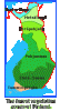
-Removed the sheep. Of course there are many other resources in my proposal that can easily be removed as well (I know I put too many), but I won't make any detailed suggestions on that (the suggestions made by others above all seem very reasonable).
-Added taiga (red areas). Of course, Finland should probably have lots of taiga too, but I didn't mark that here. BTW, maybe some of the Swedish marshes would be nicer as moorland hills + taiga?
-Added two more grassland tiles in Finland (blue areas).
-Added two island features in the north of Norway (yellow area) to represent the archipelagos Lofoten and Vesterålen, as well as the island Senja, etc. The fish is moved 2E so that it's not on an island.
-Replaced some coast by arctic coast in the northern Baltic sea (white area). This area isn't all that great for fishing (and actually frozen almost half the year). When I tried to research historical fishing in the area I mostly found information on some salmon fishing in the river mouths. Also, this limits the growth potential of cities in the area, which seems reasonable.
-Sundsvall should maybe really be 1SW of its marked location, as Steb suggests.
-I think that the path between Sweden and Norway 1NW of the marked Sundsvall should probably be blocked by a peak (as you can see, this is not marked on the map though).
As a side note, it seems strange that there is so little forest in Estonia and Latvia on the map. In reality, there's lots:
https://gabrielhemery.com/european-countries-and-their-forest-cover/
https://www.efi.int/knowledge/maps/forest
Spoiler :
-Removed the sheep. Of course there are many other resources in my proposal that can easily be removed as well (I know I put too many), but I won't make any detailed suggestions on that (the suggestions made by others above all seem very reasonable).
-Added taiga (red areas). Of course, Finland should probably have lots of taiga too, but I didn't mark that here. BTW, maybe some of the Swedish marshes would be nicer as moorland hills + taiga?
-Added two more grassland tiles in Finland (blue areas).
-Added two island features in the north of Norway (yellow area) to represent the archipelagos Lofoten and Vesterålen, as well as the island Senja, etc. The fish is moved 2E so that it's not on an island.
-Replaced some coast by arctic coast in the northern Baltic sea (white area). This area isn't all that great for fishing (and actually frozen almost half the year). When I tried to research historical fishing in the area I mostly found information on some salmon fishing in the river mouths. Also, this limits the growth potential of cities in the area, which seems reasonable.
-Sundsvall should maybe really be 1SW of its marked location, as Steb suggests.
-I think that the path between Sweden and Norway 1NW of the marked Sundsvall should probably be blocked by a peak (as you can see, this is not marked on the map though).
As a side note, it seems strange that there is so little forest in Estonia and Latvia on the map. In reality, there's lots:
https://gabrielhemery.com/european-countries-and-their-forest-cover/
https://www.efi.int/knowledge/maps/forest
Last edited:
 (And nowadays the Netherlands is
 ")
")