ozqar
King
Now to northern and Eastern Europe!
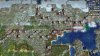
I mentioned yesterday that Poland was lacking tiles and I had also thoughts that Germany was too wide in proportion to its height (although its area was correct), Poland also looked initially a bit too flat. I looked at the political borders again to see where was the problem or what we could do about it. First of, I moved the Oder river 1W (the boundary with Poland) 1W. The river is now touching Berlin, which I don't think is a big problem. In compensation for the lost tiles, I added 3 tiles in the northern coastline. I think Germany looks much more accurate with these changes and the northern coastline is not flat anymore.
I changed the course of all the rivers a little. I made sure the Elbe was born in central Czechia and flows diagonally northwest to Hamburg (before it was wider, in line with the Oder). I made the Rhine so that it flows out of Switzerland, marks the boundary with France, and then has an eastwards-bend to keep Cologned and some of the Rhineland to its west. The Rhine touches Frankfurt, but let's assume that's the Main River (it can also be added on the south edge of the city). For the Danube, I moved it north so that Munich can be its south - it could be expanded 1W, but I thought it also worked well like this (I'm not sure how much water flows that far north in its course, and the Rhine is just next to it, so it looked a bit too much). I didn't mark it in the map yet (need to look it up), but I think the Hamburg tile and 1N should be marshes. Can someone confirm that? I believe Hamburg was settled only "late" (for the Middle Ages) and only due to favorable incentives, because the terrain was too marshy there.
By the way, we have space for Switzerland! In marking the borders, I left most of the Alps on the Italian side (because in general, there's more of them south of the border). But 4 tile Switzerland (accurate proportions) has room for Zurich or Bern. There's room in Austria for something like Innsbruck or Salzburg, but only at the expense of Munich. I think it's better to leave Munich.
Continuing with the northern coastline, I looked at Poland. I added two tiles for Gdansk (this had also been proposed by Tab911) and actually moved the Baltic countries 1 NW (Poland was too wide otherwise). I made some changes to both rivers, for the Oder, I marked a source out of the Czech Republic and west to the (new) border with Germany. I wanted to place Wroclaw there instead of Poznan (Wroclaw would be 1S of Poznan), but there's no room for it with Prague there (which I think should take preference). I moved the Vistula west and moved Warsaw west accordingly (compared to where I had placed it before moving the German border). As well as the two tiles in the north, Poland gained one additional tile south of Krakow. Poland has enough room for 4 good cities, but with Lviv (polish Lwow), Brest, and Vilnius, the commonwealth can be quite powerful. I made changes to the mountains in the south (will get to that later). As everywhere else, I ignored resource placement. I have a feeling the northern polish coast must also have some wetlands, so maybe we can add marshes if someone can look that up.

For relief, I added hills to mark a transition north of the Alps, some in western Germany (on the border with Belgium and France), on the East (the border with Czech Republic), and in the center (NE of Frankfurt). From relief maps, I think these are all accurate and they add texture, but the one in central Germany could be removed (altitude is not so high). There are some changes to the Carpathians (seen here in Poland), but explain that afterwards, and I added hills along the Carpathian northern slope as you can see here:

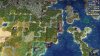
I continue to the Baltic states... I'm sure those Konigsberg fans must have seen it already. It's there. As a disclaimer: I didn't add it intentionally nor expanded and moved everything to make room for it (this was not a Konigsberg case), but I think with the changes around it, there's room for Konigsberg/Kaliningrad. Space is tight, so I see how some players could want to skip it, but in my opinion, now that there's space for it, it's important enough to serve as the Prussian capital and be in the game.
Getting back to geography, as I said earlier, I moved the Baltic states 1NW. The only other change in there is in Latvia, I love the shape of the Gulf of Livonia. This is an aesthetic choice (ie, it's either having the tile NW of Riga (as I do here) or the tile W of Tallinn (as in the original map). I added the Nema river in Lithuania and expanded the Daugava in Estonia a little bit in accordance to its real life flow. For the Daugava, it's flowing out of Russia and through Belarus as it should, while the Nema is a bit shorter than the original map. The lake 1SE of Tallinn was originally a bit further east, but I changed it there to help mark Estonia's boundary (this is Lake Peipus). I didn't look at resources here either.
For the Baltic region in general (3 countries + Kaliningrad) with the changes, the region gained 4 tiles in total, but now they are in the same proportion as Scandinavia and Finland (ie, 12 thousand km2/tile). I think the expansion is good because they can do with the space and now they're aligned with the neighboring regions. At the same time, in this region the map merges into Russia where the proportions are all considerably different... and where the eastern-most tiles could also be defined as Russian.

Now, the big question is how to make room for the changes above. I was worried Scandinavia would be a problem. I found a way to make room for this that also improves Scandinavia - you can also see these changes in the same map above. The key was that actually the Baltic Sea was 15 tiles too big to be in proportion to Scandinavia and the Baltic countries (46 tiles instead of 31, that's 150% of the correct size. Knowing this, I felt comfortable with moving the Baltics west as I had (this also makes room for European Russia). To accomodate the expansion in Germany, I moved the Copenhagen and Odense tiles in Denmark 1N. Jutland looks a bit different now, but I'm ok with the new shape (it's hard to get it right at this scale). Copenhagen is still connected to Denmark and not to Sweden, as intended. Across the straits, I had to remove a tile in Sweden (1 NW of Malmo) to keep the countries separate.
Now, having that oversized Baltic Sea also meant that Scandinavia was too long east-west (not great because in the map it's already pulled westwards to make it fit in the map). I removed I think 1 column of land tiles in northern Sweden/Norway as shown here, and moved everything at Oslo's latitude 1E to fill the gap (also the rest of Norway, to keep the shape; but I mean, southwest Sweden is exactly where it was). With the changes I lost one of the two lakes in southern Sweden (lol, not sure where it went missing), and Stockholm is not a bump anymore, but considering the larger shape of the peninsula, this all works well for me. Btw, The Baltic Sea is still larger than it should be, but I thought removing one more column would make it too narrow (we can discuss though).
Now, while the changes worked very nicely for Sweden, Norway, and the Baltics, Finland did suffer a little bit. It lost a row (as the Baltics moved north), so I moved everything up in compensation (this also means moving the region where the tundra starts). I also moved it West to align it with the new Baltics. Now it's a bit "fatter" but it retains its correct size. The only change I did to improve the shape is expanding the Gulf of Bothnia two tiles north to increase the coastline. I didn't look into the Scandinavian terrain (I know there were changes proposed earlier) nor to its rivers or relief (didn't have time), for lack of time. If people like this changes, then we could look into it. As everywhere else, I ignored the resources.
All in all, Finland is a bit fat and northern Fennoscandia (ie, the Lapland region) is very small in this proposal, maybe it lost 8 tiles or so? But considering that this allows improvements in Germany, Poland and the Baltics, and slightly helps Russia, and improves the shape of southern Norway and Sweden, and improves the size of the Baltic Sea... it's a good price to pay I think.
To be continued...
I mentioned yesterday that Poland was lacking tiles and I had also thoughts that Germany was too wide in proportion to its height (although its area was correct), Poland also looked initially a bit too flat. I looked at the political borders again to see where was the problem or what we could do about it. First of, I moved the Oder river 1W (the boundary with Poland) 1W. The river is now touching Berlin, which I don't think is a big problem. In compensation for the lost tiles, I added 3 tiles in the northern coastline. I think Germany looks much more accurate with these changes and the northern coastline is not flat anymore.
I changed the course of all the rivers a little. I made sure the Elbe was born in central Czechia and flows diagonally northwest to Hamburg (before it was wider, in line with the Oder). I made the Rhine so that it flows out of Switzerland, marks the boundary with France, and then has an eastwards-bend to keep Cologned and some of the Rhineland to its west. The Rhine touches Frankfurt, but let's assume that's the Main River (it can also be added on the south edge of the city). For the Danube, I moved it north so that Munich can be its south - it could be expanded 1W, but I thought it also worked well like this (I'm not sure how much water flows that far north in its course, and the Rhine is just next to it, so it looked a bit too much). I didn't mark it in the map yet (need to look it up), but I think the Hamburg tile and 1N should be marshes. Can someone confirm that? I believe Hamburg was settled only "late" (for the Middle Ages) and only due to favorable incentives, because the terrain was too marshy there.
By the way, we have space for Switzerland! In marking the borders, I left most of the Alps on the Italian side (because in general, there's more of them south of the border). But 4 tile Switzerland (accurate proportions) has room for Zurich or Bern. There's room in Austria for something like Innsbruck or Salzburg, but only at the expense of Munich. I think it's better to leave Munich.
Continuing with the northern coastline, I looked at Poland. I added two tiles for Gdansk (this had also been proposed by Tab911) and actually moved the Baltic countries 1 NW (Poland was too wide otherwise). I made some changes to both rivers, for the Oder, I marked a source out of the Czech Republic and west to the (new) border with Germany. I wanted to place Wroclaw there instead of Poznan (Wroclaw would be 1S of Poznan), but there's no room for it with Prague there (which I think should take preference). I moved the Vistula west and moved Warsaw west accordingly (compared to where I had placed it before moving the German border). As well as the two tiles in the north, Poland gained one additional tile south of Krakow. Poland has enough room for 4 good cities, but with Lviv (polish Lwow), Brest, and Vilnius, the commonwealth can be quite powerful. I made changes to the mountains in the south (will get to that later). As everywhere else, I ignored resource placement. I have a feeling the northern polish coast must also have some wetlands, so maybe we can add marshes if someone can look that up.
Spoiler Rearranged Germany and Poland: :
For relief, I added hills to mark a transition north of the Alps, some in western Germany (on the border with Belgium and France), on the East (the border with Czech Republic), and in the center (NE of Frankfurt). From relief maps, I think these are all accurate and they add texture, but the one in central Germany could be removed (altitude is not so high). There are some changes to the Carpathians (seen here in Poland), but explain that afterwards, and I added hills along the Carpathian northern slope as you can see here:
Spoiler Germany and Poland relief: :
I continue to the Baltic states... I'm sure those Konigsberg fans must have seen it already. It's there. As a disclaimer: I didn't add it intentionally nor expanded and moved everything to make room for it (this was not a Konigsberg case), but I think with the changes around it, there's room for Konigsberg/Kaliningrad. Space is tight, so I see how some players could want to skip it, but in my opinion, now that there's space for it, it's important enough to serve as the Prussian capital and be in the game.
Getting back to geography, as I said earlier, I moved the Baltic states 1NW. The only other change in there is in Latvia, I love the shape of the Gulf of Livonia. This is an aesthetic choice (ie, it's either having the tile NW of Riga (as I do here) or the tile W of Tallinn (as in the original map). I added the Nema river in Lithuania and expanded the Daugava in Estonia a little bit in accordance to its real life flow. For the Daugava, it's flowing out of Russia and through Belarus as it should, while the Nema is a bit shorter than the original map. The lake 1SE of Tallinn was originally a bit further east, but I changed it there to help mark Estonia's boundary (this is Lake Peipus). I didn't look at resources here either.
For the Baltic region in general (3 countries + Kaliningrad) with the changes, the region gained 4 tiles in total, but now they are in the same proportion as Scandinavia and Finland (ie, 12 thousand km2/tile). I think the expansion is good because they can do with the space and now they're aligned with the neighboring regions. At the same time, in this region the map merges into Russia where the proportions are all considerably different... and where the eastern-most tiles could also be defined as Russian.
Spoiler Rearranged Baltics and Scandinavia: :
Now, the big question is how to make room for the changes above. I was worried Scandinavia would be a problem. I found a way to make room for this that also improves Scandinavia - you can also see these changes in the same map above. The key was that actually the Baltic Sea was 15 tiles too big to be in proportion to Scandinavia and the Baltic countries (46 tiles instead of 31, that's 150% of the correct size. Knowing this, I felt comfortable with moving the Baltics west as I had (this also makes room for European Russia). To accomodate the expansion in Germany, I moved the Copenhagen and Odense tiles in Denmark 1N. Jutland looks a bit different now, but I'm ok with the new shape (it's hard to get it right at this scale). Copenhagen is still connected to Denmark and not to Sweden, as intended. Across the straits, I had to remove a tile in Sweden (1 NW of Malmo) to keep the countries separate.
Now, having that oversized Baltic Sea also meant that Scandinavia was too long east-west (not great because in the map it's already pulled westwards to make it fit in the map). I removed I think 1 column of land tiles in northern Sweden/Norway as shown here, and moved everything at Oslo's latitude 1E to fill the gap (also the rest of Norway, to keep the shape; but I mean, southwest Sweden is exactly where it was). With the changes I lost one of the two lakes in southern Sweden (lol, not sure where it went missing), and Stockholm is not a bump anymore, but considering the larger shape of the peninsula, this all works well for me. Btw, The Baltic Sea is still larger than it should be, but I thought removing one more column would make it too narrow (we can discuss though).
Now, while the changes worked very nicely for Sweden, Norway, and the Baltics, Finland did suffer a little bit. It lost a row (as the Baltics moved north), so I moved everything up in compensation (this also means moving the region where the tundra starts). I also moved it West to align it with the new Baltics. Now it's a bit "fatter" but it retains its correct size. The only change I did to improve the shape is expanding the Gulf of Bothnia two tiles north to increase the coastline. I didn't look into the Scandinavian terrain (I know there were changes proposed earlier) nor to its rivers or relief (didn't have time), for lack of time. If people like this changes, then we could look into it. As everywhere else, I ignored the resources.
All in all, Finland is a bit fat and northern Fennoscandia (ie, the Lapland region) is very small in this proposal, maybe it lost 8 tiles or so? But considering that this allows improvements in Germany, Poland and the Baltics, and slightly helps Russia, and improves the shape of southern Norway and Sweden, and improves the size of the Baltic Sea... it's a good price to pay I think.
To be continued...