• Our friends from AlphaCentauri2.info are in need of technical assistance. If you have experience with the LAMP stack and some hours to spare, please help them out and post here.

[Development] Map Suggestions

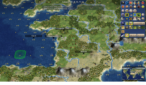
Took a look at the actual in-game map and changed just a few things:
doc_france.png
-Loire river moved north as I felt that was more accurate to the local geography.
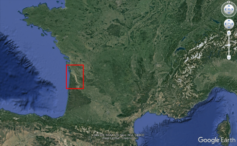
-Extended the Garonne river, to represent the very noticeable Gironde estuary.
gironde.png
-Fish moved south to discourage settling Rennes over Nantes.
-Sheep moved north to make room for a potential Toulouse city/cottage.
 
Last edited:
Upon playing around a bit with city names in Central Asia, I realized that the probably currently intended location for Ordukent (1N of the spot I marked) doesn't really make that much sense to me (it was located slightly east of Bishkek) and that the area overall could maybe be adjusted a bit. So I took a quick shot at it.

Spoiler Ordukent :
ordukent2.jpg

-Added (a part of) the Chu river (https://en.wikipedia.org/wiki/File:Syrdaryamap.png).

-Changed Almaty tile and tile 1E to plains hills.

-Put desert (https://en.wikipedia.org/wiki/Saryesik-Atyrau_Desert) south of Lake Balkash, added oasis (Ili delta wetlands).

-Rearranged sheep and millet.
 
Last edited:
Interesting map I just came across:
Spoiler :
europelivestock.jpg

Obviously current time and only Europe but still helpful.
 
I've took a brief look again in Africa after some of my suggestions in the new African civs thread. While I told about canonical cities, terrain and resources, I've realized that not only I didn't put them on the new map for better visualization or or even made proper suggestions in a dedicated post here. Nonetheless, stormogulen and Tab911 covered much of what I've said in the Sahelian (Kanem-Bornu and Songhai) and Zimbabwe discussions. That left only Madagascar, which received only a quick look from stormogulen and some remarks from Steb; considering that it seems that those haven't been implemented yet and my later discussion about the island/civ, I'm also making some few suggestions here.

Spoiler Madagascar :

Civ4ScreenShot0006.JPG


  • Switched few tiles to make them more aligned with real-world Madagascar's topography, changed some tiles for savannah terrain (some of the rainforest tiles could also become savannah forests, but this seems better aesthetically), added a hill 2S from Mahajanga) and opened space (moving the mountain 1S) for a more accurate Antananarivo (the current and historical capital). You can see here the changes without the jungles/rainforests:
    Spoiler :
    Civ4ScreenShot0008.JPG
    .
  • Added Rice (the most important Malagasy crop since the pre-colonial times) near Antananarivo and a Whale (replacing the original Crab) between Madagascar and Réunion. Moved Rare Earths and Uranium to slightly more appropriate locations, according to data found on the internet about mining zones and ore deposits. Moved the Spice 1NW from the original position, opening space for Ft. Dauphin. Nonetheless, while I've left the Spice in the final suggestion, I'm honestly divided about it because I couldn't find many historical recordings stressing its importance in the southern areas of the island (cinnamon, on the other hand, was somewhat important in the north for the Kilwa colonies/trade partners in medieval age). Could be replaced by a Cow, which was the main livestock from the southern Madagascar and was historically important for the people that lived there.
  • Like stormogulen's suggestion, the later resource spawn (19th century) is another Spice (Vanilla) in the Ilharana/Diego Suarez tile since Madagascar is the world's largest producer. I'm honestly unsure about his Coffee inclusion, because while it did was introduced by later Merina Kingom (and French colonial authorities), it does not seem to have been that important overall and may turn the island into a too much resource-rich area. Could be a second Vanilla, though.
  • Added some suggestions for canonical cities: Ilharana/Vohemar and Mahajanga/Manzalājī during the Medieval Age (both were linked with Kilwa Sultanate and were the main Muslim cities when the Portuguese arrived); Fort Dauphin/Tôlanaro (the oldest and main French colony during much time; the Portuguese also settled Matatana, the first European colony in the island, in the same spot, though they later abandoned it); Antananarivo, the capital from the Merina Kingdom, French Colonial Madagascar and the modern country; Tamatave/Toamasina, the main seaport, is added as an alternative option if Antananarivo is razed and the French settle a new city nearby; likewise, Diego Suarez/Antsiranana could be another possible European settlement in the northern tip of the island if the old Muslim city is not settled or is razed.
 
Last edited:
Coffee isn't really obligatory for Madagascar IMO, but AFAIK it was the most important export crop during much of 1900's (with vanilla only really starting to overtake it towards the end), see e.g: https://core.ac.uk/download/pdf/6457681.pdf (some excerpts below). I would give it higher priority than a third spice or either of the two present mining resources for sure.

Quotes from the linked paper:

“At the end of the 1950s, agricultural production was quite diversified and relatively resilient to external shocks. Rice, the staple food product for the Malagasy population, accounted for 43 percent of total production value, followed by coffee (14 percent), sugar cane (6 percent), cassava (5 percent), potatoes, vanilla and cloves (3 percent each), and various lesser products.”

“Yet, from 1974 to 1987, more than half of Madagascar exports were concentrated on coffee and vanilla (around 30 percent are from coffee).”

“Coffee, cloves, pepper and cocoa represented, respectively, 20 percent, 14 percent, 6 percent and 5 percent of agricultural exports during 1995-2005.”
 
Alright, it seems important enough to add giving the data that you presented. My sources were based on the pre-1900 Madagascar (when coffee wasn't that important, probably was on the same level of sugar cane overall), so that's why I pointed that.

The issue with the Spices is defining what they will represent; giving the island's share in modern vanilla world's production, it seems enough to have at least two of this type. The third one would represent the pre-colonial non-vanilla spices traded by Muslim cities in the north. An alternative option is to turn a non-vanilla Spice into the Vanilla variant at the same time of new resource spawns, so we can dissmiss the third one.

Agreed in the mining resources: Madagascar mining industry was not much developed in the past or even in the present, and most sources I've found say generic things about the presence of ores and potential production rather than actual or historical mining.
 
Last edited:
Not even the uranium? I wonder what led Rhye to place it there in the current map.
 
I guess it is because Madagascar still has unexplored uranium reserves and, historically, was a source for France between 1946-1966 for what I could find. Nonetheless, Madagascar historical production was not that large. Wiki indicates that the island production (785 tons) was much smaller than that of Argentina (2.582) or Portugal (3.720) and was slightly larger than Belgium (686) and Poland (650) historical production. Probably Rhye needed to find an interesting resource for the island and chose uranium for uniqueness and gameplay reasons.
 
That makes sense, but it does not seem to be one of the principal sources for French uranium (which I agree they should have access to). We already have domestic uranium for France so they will have access in all circumstances. My understanding is that its primary source of uranium is West Africa (both during the Cold War but also still in current times), where we already have lots of uranium available for them. So I think it's completely okay to remove it from Madagascar.

This is a good example of what I mean with map inertia: someone puts a resource for semi good reasons and everyone copies that decision with knowing the reasoning behind it, and it ends up never being questioned.
 
Spoiler Colombia :

CO.jpg


Highlighted tile is La Guajira, a much dryer region of Colombia which produces something like 60% of the salt in the country. I have also added a flood plain to help with extra food but it is not geographically accurate.
Gold has moved to Antioquia, this was where the Muisca people mined gold and also the reason the Spanish started moving to the area.
Coffee spawns later on the tile below. This is Colombia's Coffe Triangle region, where most of the stuff is produced. I think Colombia should get two, but I do not know where else to put more.
Sugar added to Cali. This was the most important historical crop with the Spanish and Colombia also deserves a source of it.
Emeralds have been moved to Bogota tile. The majority of Emeralds actually come from just north of Bogota, but the corn should stay so I put it on the tile.


Spoiler Carib :

CR.jpg


Added rainforest to Miami
Placed marsh to the north which should get cleared around 1800 and have oranges spawn. I don't know if this is already plan but Florida needs oranges. It is also a very swampy state so I think it could use another marsh to hamper development until at least 1800.
Added gold to Hispanola. Other spawning resources aside, one of the Spaniard's primary motivations in settling Hispanola was because of the source of gold, the most famous being Minas Vieja (Old Mines)


Spoiler Central America :

CA.jpg


Replaced plains with savanna. I think the Savannas work better with the highland regions of Honduras rather than plains.
Jungle added to Honduran/Nicaraguan coast. This is an underdeveloped, heavily vegetated area. They also block ahistoric Atlantic cities in this area.
Highlighted tile is now a grassland hill. Being south of lake Nicaragua, I think this tile should be the city of San Jose which was very important in early colonial times.
Moved fish to reach San Jose.
Banana added, jade moved north. The jade is now grabbable by the Olmecs and Maya, as it should be. Another source of banana should be added to the region that gave us the term, "Banana Republic."
Stone removed from southern Mexico, added to Palenque and Cerro Cintepec. Palenque was an important source of Maya stone while Cerro Cintepec was the stone used by the Olmecs.
Removed corn from Tulum. Tulum was one of the biggest Maya settlements, so I'd like the tile open for it. The city as of now lacks productive power but it is a relevant place for the Maya to settle. I couldn't find significant agriculture to justify the corn too.
Added more rainforests to reflect dense vegetation.
Removed rubber. I can't remember if this was meant to signify something else but Mexico has only become a rubber producer only as of late, almost all of which comes from the Yucutan region rather than here.


Spoiler USA :

AT.jpg


I saw a recent suggestion at making coastal Carolina a marsh, here's a look with islands as the Outer Banks (OBX).
Moved Winston-Salem Tobacco north, blocks Atlantic settlement here.
To block other spots, spawning Virginia horses and Carolina Rice.
Atlanta is perhaps the most important city in the US South from 1800 onward so I have made the tile flat and moved the Iron into Alabama.
Cotton spawns 1750 to block the river spot to the east. I'm sure there are others planned to spawn too, Atlanta was the center of the "Cotton Kingdom."
Final proposal is Marble north of DC. Most of Washington's federal buildings are made with marble much of which came from just north of Baltimore. It may be too much marble for the US, but I believe DC should at least get one in its BFC.

 
This is a good example of what I mean with map inertia: someone puts a resource for semi good reasons and everyone copies that decision with knowing the reasoning behind it, and it ends up never being questioned.
This is also why I really like this topic. I learn so much about the most obscure things in the world. :)
 
The Muisca also mined a lot of salt though. I think salt should be in their area.
 
Spoiler Colombia :

View attachment 609348

Highlighted tile is La Guajira, a much dryer region of Colombia which produces something like 60% of the salt in the country. I have also added a flood plain to help with extra food but it is not geographically accurate.
Gold has moved to Antioquia, this was where the Muisca people mined gold and also the reason the Spanish started moving to the area.
Coffee spawns later on the tile below. This is Colombia's Coffe Triangle region, where most of the stuff is produced. I think Colombia should get two, but I do not know where else to put more.
Sugar added to Cali. This was the most important historical crop with the Spanish and Colombia also deserves a source of it.
Emeralds have been moved to Bogota tile. The majority of Emeralds actually come from just north of Bogota, but the corn should stay so I put it on the tile.


Wouldn't having a resource on the Bogota tile discourage settling it? Or is there another city you want to favour?
 
Spoiler Central Asia :
ca2.jpg

-Added some trees in areas of Northern Afghanistan that used to have pistachio woodlands. Two tiles changed from semidesert to plains.

-Added horse near Turkmenistan/Iran border (https://en.wikipedia.org/wiki/Akhal-Teke).

-Moved salt in Turkmenistan to be reachable from Khwarezmian cities.

-Added salt flats SW and NE of Aral Sea. Strictly speaking both are too small to justify entire tiles. But I like salt flats.

-Moved Kwarazmian stone 1W so that it's on a floodplain. According to the book 'The Lands of the Eastern Caliphate' by Guy Le Strange, there were quarries in that area that supplied the Khwarazmian cities.

-Given all the recent discussion of uranium I couldn't resist putting one in Uzbekistan. It is among the major producers and seems to have been the main provider of uranium for Soviet nukes historically.

-Turned two semidesert tiles near Tashkent into plains.

-Turned coal in Ferghana valley into salt. Salt mining is a traditional industry there, which the city of Namangan is even named after (https://en.wikipedia.org/wiki/Namangan#History). Keeping the coal would be fine though.


Spoiler Indochina :
ic.jpg

-Added salt on the Korat Plateau. Its salt resources were worked from prehistoric times and may have motivated Khmer expansion there.

-Added aluminium for Vietnam's massive bauxite deposits (https://en.wikipedia.org/wiki/Bauxite_mining_in_Vietnam). Actual mining there has only started very recently though.


Spoiler North Vietnam, China :
china.jpg

-Added coal representing anthracite of Vietnam (https://en.wikipedia.org/wiki/Quảng_Ninh_Province). Vietnam has fairly large reserves of high-quality coal.

-Moved Vietnamese Rare Earths north (they were at the suggested aluminium spot in the Indochina screenshot). While rare earths do occur along the coast, the major deposits (Nam Xe, Dong Pao) and actual mines are in the mountains near the Chinese border. There is currently a gold here. Given the amount of other luxuries in the area it might not be needed, but one could consider placing gold in the general area. In ancient times there was gold mining in the Pearl River basin, and nowadays there are massive mines in Guizhou.

-Added Rare Earths near the Maoniuping deposit in Sichuan, the third major RE mining areas in China (Inner Mongolia and southeast China being the others and already represented).
 
I am still not sure,
What is the difference between Jungle and Rainforest in the game?
 
Why don't you open civilopedia to check? I don't understand the question.
 
Why don't you open civilopedia to check? I don't understand the question.
I mean in a geographical sense

What does Rainforest represent as opposed to jungle. Does it represent different amounts of precipitation? Is the different purely for gameplay reasons or show different biomes.

I don't think the Civilipedia explains
 
Another thing I wanted to ask, is it would be possible to separate Deciduous and Coniferous forests as features, and if they were to be separated how would the two be different gameplay wise? Since the new map is upcoming I was thinking about the forests.

In Worldbuilder it seems that when a forest is placed, the two come up randomly. I wonder how hard it would be to separate the two graphics.
 
I mean in a geographical sense

What does Rainforest represent as opposed to jungle. Does it represent different amounts of precipitation? Is the different purely for gameplay reasons or show different biomes.

I don't think the Civilipedia explains

Both do represent tropical forest. The main difference is when the tiles become usable. Jungle tiles are not usable untill late in the game, whereas rainforests are usable much earlier. Having two tropical forest types gives some control when a tropical forest become usable or not.

Another thing I wanted to ask, is it would be possible to separate Deciduous and Coniferous forests as features, and if they were to be separated how would the two be different gameplay wise? Since the new map is upcoming I was thinking about the forests.

Yes, it is technically possible. (And its not even that hard) But unless they are different gameplay wise, what would be purpose?

In Worldbuilder it seems that when a forest is placed, the two come up randomly. I wonder how hard it would be to separate the two graphics.

You can select which forest variety you want to place in the WB. Also, the new map has even more forest varieties.
 
Back
Top Bottom