[Development] Map Suggestions

No, I would actually most prefer proposals that change the actual landmass and not just what terrain and resources there are. The reason is that at some point I would like to enter the next stage of the city name manager development, and after you do that most coastlines etc. should be locked in.

So if someone wants to make an attempt at reshaping Japan, please go for it. Everything else that goes in a similar direction as well of course. Maybe I will also make my own attempts.
I think that at this point, all the land mass changes have been adjusted.

That said, India still looks weird to me because of how elongated it is, but I figure that is for gameplay reasons
 
Siberia was awesome, totally recommend.

Continue. West Siberian plain.
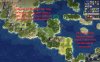
Before:

View attachment 504830

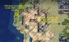
Red - state border, blue - redrawn rivers, turquoise - approximate position of swamps.

Overview:
Rivers are mostly correct, as I say. Fixes for them mostly supposed to place towns on the correct banks of them, and sometimes - to exaggerate their bends. Only suggestion — probably Tagil-Tura river (light blue) can be added as source of fresh water for cities of middle Ural (Tagil and Yekaterinburg).

Hills and mountains are ok - West Siberian plain is very flat, and we can just add some hills for Siberian Uvals east of Nizhnevartovsk. Or not, because they are rarely over 200 m height.

Most problem in West Siberia is incorrect placement of swamps - they are, firstly, located too far too the south, and, secondly, placed mostly in the banks of the rivers, blocking most of the historical city spots.

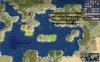
(Reference map for swamps)
%D0%91%D0%BE%D0%BB%D0%BE%D1%82%D0%B0%20%D0%A0%D0%BE%D1%81%D1%81%D0%B8%D0%B8%20%D0%B8%20%D0%A1%D0%B8%D0%B1%D0%B8%D1%80%D0%B8.%20%D0%9A%D0%B0%D1%80%D1%82%D0%B0%20%D0%B1%D0%BE%D0%BB%D0%BE%D1%82%20%D0%A0%D0%BE%D1%81%D1%81%D0%B8%D0%B8.gif


Resources of the region mostly includes oil, furs and some food resources (deers in the north part, general food - in the south).

So, fixes

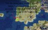
View attachment 504845

A. Added oil of West Siberian petroleum province; added deers for supporting northwest Siberian towns.
B. Added millet for enriching cities of Yekaterinburg and Tyumen.
C. Horses for Siberian Tatars and millet for Omsk
D. Sheeps moved 1N, added wheat and iron, representing iron ores of Bakcharskoye mine. I'm in doubt, though - while this deposit is valuable, it was found relatively late. Probably need to see Altay region as whole.

There are so many important and reasonable suggesions about Western Siberia!
I am really enjoy when I read them:)
Have You time/ideas/inspiration for Eastern Siberia/Far East?
 
Some "invasion" to pro-Japanese map-discussion
I've prepared some suggestions to the United Kingdom
NEW TERRAIN:
* Moorlans to north part of Scotland (I suppose it will help decrease potential of Inverness/Edinburg as monster-cities);

NEW RESOURSES + SUGGESTIONS
* "Chesire" SALT to North-West England (full reference is here https://en.wikipedia.org/wiki/Salt_in_Cheshire)
* POTATO to Ireland: potato farming occupy so many lands here and even stimulate local hunger in ХIХ century (https://blog.crystal-travel.com/irelands-relationship-with-the-potato)
* UK OIL go 2 tiles North - it's more accurate - some people already found and fiх this case;
* Perhaps ther is some sence to remove HORSES from Ireland to South England (horses play a great role in English nobility culture + it's easist way how to increse productivity in the mediaval period in London);

GEORAFICAL CHANGES:
* Grampian montains (and Ben Navis) pepresent by one Rock in Scotland (https://www.ezilon.com/maps/europe/united-kingdom-physical-maps.html)
* Eхtra Islands for English Chanell near the French Normandia (https://en.wikipedia.org/wiki/Channel_Islands)
* BRISTOL Chanell between South part of England and Wales (https://www.ezilon.com/maps/europe/united-kingdom-physical-maps.html)
May be the last one is not so important and we can use current small river;

Nowadays I think that: Ban Navis (Scotish Rocks are not so high) and also Bristol Chanell in Wales are not very god ideas (currently river is more convenient and it's very similar with S-F Bay which represents now by a small Californian river

But what about moorland in Scotland which should be decrease it's growth potential
And also new islands near French Normandia? (https://en.wikipedia.org/wiki/Channel_Islands)
 
Hey, I don't know that anyone suggested this but I think that Hong Kong is a good candidate for lagoon. The lagoon would be on the eastern side of the Pearl river delta and Guangzhou could be 2N or 2N1W of there. It is very much a city built on/in a harbour and it would also give space for both Guangzhou and Hong Kong. That said, it might look strange to have a city jutting out from South China like that.
 
Hey, I don't know that anyone suggested this but I think that Hong Kong is a good candidate for lagoon. The lagoon would be on the eastern side of the Pearl river delta and Guangzhou could be 2N or 2N1W of there. It is very much a city built on/in a harbour and it would also give space for both Guangzhou and Hong Kong. That said, it might look strange to have a city jutting out from South China like that.

No, Hong Kong is not really a lagoon any more than any other coastal city is. I would also add that a lot of the territory of Hong Kong (i.e. the parts just outside the urban area that's not practical to develop) is actually quite hilly, which further makes a lagoon tile inappropriate.
 
No, Hong Kong is not really a lagoon any more than any other coastal city is. I would also add that a lot of the territory of Hong Kong (i.e. the parts just outside the urban area that's not practical to develop) is actually quite hilly, which further makes a lagoon tile inappropriate.
I mean, much of Kowloon City/East Kowloon, as well as Hong Kong Island facing Victoria Harbour is reclaimed land that is basically at sea level. And Kowloon being the most populated area of Hong Kong means that a great deal of people are literally living on top of the historic harbour. Where I live used to be houseboats. In fact, to this day many people (illegally) live on boats in various harbours around the city and there are many notable fishing villages in New Territories where people have built homes literally on the water. There's an entire "ethnic group" in Hong Kong called the Tanka. They are also known as "Boat Dwellers" because they lived on boats long before Hong Kong was even established as a British colony. To say that Hong Kong is not any more a candidate for a transitional water/land tile as any coastal city is a bit disingenuous I think. But you're right it's not a lagoon by definition. I just think for the purposes of fitting GZ and Hong Kong and distinguishing Hong Kong from the mainland a lagoon tile could be used as it wouldn't make sense to extend a land tile south of the mainland. I understand this isn't a priority however.

I think even just historically/economically/geopolitically speaking. The very nature of Hong Kong was that it had a stronger connection to the sea than the land it was carved from. For much of its history there was virtually no way to cross into Mainland China by land.
 
Last edited:
I'm looking forward to the larger map and I think I can put my two cents in it, most notably in regards to Indonesian archipelago area. However my computer doesn't like Github very much and so until I find a way to work it out I'll give general thoughts based on previous discussions about it in this thread and previous ones without screenshot. If anyone can provide me with the latest screenshot of the archipelago that would also be very appreciated; regardless here are my current thoughts:

[Note that a lot of these suggestion are conveyed based on info I get from screenshots from like January-June 2018, Courtesy of @AessaSH]

maritime-sea-5-islands1-jpg.485375
  1. I think the overall size of the archipelago and each major islands are good enough so I don't have much recommended changes there. I personally don't like the shape of Sulawesi and the Moluccas where I would myself cut the 2 tile Ambon Island into one (replacing it with a coast) and move the grassland tile in South Sulawesi east, replacing its previous spot with a coast so to somewhat preserve the island's K-like shape and the Gulf of Boni. The tile that Ambon Island lost can be compensated with an island tile instead. Though this suggestion is more aesthetic related and admittedly the current setup might provide for more productive cities, so eitherway I am alright. The shape of Nusa Tenggara (Lesser Sunda Islands) are also quite weird but I am not sure what I'd suggest, I suppose it should depend on the goal on whether it should have its own city location or merely workable tiles for a city in the Moluccas or South Sulawesi. I think having it be supporting tiles instead would be better to represent the region overall since its relatively underpopulated, isolated, and no major kingdom have risen in that area though small towns and cities are known to trade with Makassar in Sulawesi and Ternate in the Moluccas.

  2. There's several suggestions revolving around making Java, and to some extent the rest of the archipelago highly populated by adding resources, tiles, or even having Indonesian/Javanese civ with the special power of 2 citizens being able to work a single tile. I do recommend against these depending on the overall goal/theme of the Indonesian civ - if it is to represent its overall or pre-industrial history then high levels of population and density as it is today would be inaccurate - as it is something that only occured in the 1900s and amplified after the 1950s. Prior to that, the archipelago including Java itself is underpopulated and not at all dense. As an example Java itself is estimated to only have about 4 million people in the 1600s and 5 million by 1800s; for the outer Indonesian islands (everything else besides Java) its 6 million in the 1600s and 8 million in the 1800s. Whereas Japan at the same timeframe has 15 and then 30 million in total, Britain and Ireland has 5 and then 15 million. Both has more or equivalent population to an archipelago extending a distance equivalent to London-Kabul; so needless to say Indonesia was underpopulated then.

    So what I'd recommend is to have scripted resource e.g. additional rice as additions by the 1900s instead. Its not that Java isn't arable or that rice isn't prevalent, most of it went to be traded to places on the outer islands in exchange of their local products. I'd have more details on this and other map evolutions but I'll save it until I can access the map directly and I'll put it in the map evolution thread. If any single rice source is to be available in Java I think it would be more fitting in Eastern Java rather than West (based on the latest screenshot I saw) since that's where most major Javanese interior kingdoms were based on.

  3. In the debate regarding 2 vs 3 cities in Java I personally think two is good enough; with one city in the west capable of representing western kingdoms like Sunda and Banten - it is also the base of power of the Dutch in the early stages of their presence and should be the one taken in a potential trade company event. The other one in the east represents the cradle of many major rice-based interior Javanese kingdoms whether its Kediri, Singhasari, or Majapahit. I can get the argument for a 3rd central city which could stand for Mataram and its successors - and the fact the wonder Borobudur and the currently proposed Prambanan would be located here, however in my personal opinion the center is more of an extension of the east and at best buffer between the west and east, not to mention the clutter it would cause in game. So I'd recommend sticking with two.

  4. For other islands I am uncertain myself, the outer islands are quite underpopulated and isolated in contrast to Java for most of history. For Sumatra there should be at least two cities - one in the north which stands for Aceh, Pasai, Deli (Medan) and the kingdoms they represent, one in the south which would naturally be Palembang. Sumatra's history would've necessitate including another in the Minangkabau (Western Sumatra) area which has its own distinct history and dynamic from the other two, but arguably theirs are more minor so they shouldn't be a priority and when settled shouldn't really be a great spot. Whilst the southern area based on the Musi river has been prominent for a long time and had been the base of the Srivijaya maritime empire, the northern and western ones comes later and only really became prominent in the early days of Islamic arrival, so an option is to have it covered in jungles at start and clear it for settlement by the 1200-1300s. Though having it open from the beginning can still be an option since there's historical basis in the pre-Islamic city and minor kingdoms of Pagaruyyung for the west and Lamuri for the north.

  5. Borneo is large, geographically difficult, and sparesly populated - back then and even today. The last screenshot I saw has a good portion of Borneo's coast being clear grassland as opposed to jungles.I am not superbly familiar with the historical details of Borneo but as far as I know the city-states and local kingdoms are largely minor ones and they interact with each other and with the rest of the archipelago by sea due to geographical isolation (that is also very present in other islands) so I am not sure about having the island this open, especially early game; like Sumatra it might be best to be represented as isolated jungles that would clear up overtime - with Kutai in East Kalimantan being the first available area followed by Banjar/Banjarmasin, Sukadana, and Tanjungpura later. However if its for game balance purposes then having it largely clear would be fine.

  6. I have no additional thought to Sulawesi beyond what has been elaborated in Point 1, I think a single city here which would be Makassar should be sufficient. If there's ever a need for a second city then it would be Manado/Gorontalo in the north - though it realistically it shouldn't pop up anytime earlier before the historical period where the Dutch arrived, even then neither are very significant. In regards to Moluccas, so far I think its well represented in the map, regardless of the current setup or in my proposed change. A city here would exert control over the Moluccan Islands and obtain control of spices from the islands and parts of New Guinea where both the Ternate/Tidorean sultanates and the Dutch VOC did historically. Finally, I am not sure what to add of Papua, pre-colonial historical records of the region is limited and mostly points to rudimentary hunter-gatherer-subsistence farming societies being prevalent on the island. As far as I know there are some form of interaction with some tribes/villages of the coast with the nearby Moluccan sultanate of Ternate/Tidore, most notably in Raja Ampat, however I don't think anything goes beyond that and the interior is a historical black hole. Possible early settlement should be in the western peninsula, otherwise Jayapura/Hollandia or Merauke/Ermasoe should be available, preferably having it being jungle at start and opening up only in the 1900s.
  7. I'd personally refrain from using peak tiles since I think for most places (like in Java, Sulawesi, and Sumatra) the mountain tiles would be better represented by jungles or jungle hills instead, so to give it inaccessibility for most units but still workable. Traditionally, its these 'interior' and relatively isolated regions which supplied the coastal trading cities with their source of food. So the remaining peaks should in Borneo, in the mountain range between the borders of Indonesian Kalimantan and East Malaysia and also New Guinea. Though I do note that jungles only provide 1F so might not actually be great at interior food sources, however I do think its still more representative of the situation rather than mountains.
Regardless, all my recommendations would certainly depend on what is intended for the civ/region itself and a good portion of my recommendation is based on having a one Indonesian archipelago civ, if it were to be divided into Malay and Javanese then there'd be differences here and there and I'd talk about that when that does happen. I also haven't commented on Malay Peninsula, Malaysian part of Borneo, and Philippines because I don't feel like having sufficient knowledge of these areas to add much.

Lastly, I apologize for all text and no screenshots.
 
Last edited:
I'm looking forward to the larger map and I think I can put my two cents in it, most notably in regards to Indonesian archipelago area. However my computer doesn't like Github very much and so until I find a way to work it out I'll give general thoughts based on previous discussions about it in this thread and previous ones without screenshot. If anyone can provide me with the latest screenshot of the archipelago that would also be very appreciated; regardless here are my current thoughts:

[Note that a lot of these suggestion are conveyed based on info I get from screenshots from like January-June 2018, Courtesy of @AessaSH]

maritime-sea-5-islands1-jpg.485375
  1. I think the overall size of the archipelago and each major islands are good enough so I don't have much recommended changes there. I personally don't like the shape of Sulawesi and the Moluccas where I would myself cut the 2 tile Ambon Island into one (replacing it with a coast) and move the grassland tile in South Sulawesi east, replacing its previous spot with a coast so to somewhat preserve the island's K-like shape and the Gulf of Boni. The tile that Ambon Island lost can be compensated with an island tile instead. Though this suggestion is more aesthetic related and admittedly the current setup might provide for more productive cities, so eitherway I am alright. The shape of Nusa Tenggara (Lesser Sunda Islands) are also quite weird but I am not sure what I'd suggest, I suppose it should depend on the goal on whether it should have its own city location or merely workable tiles for a city in the Moluccas or South Sulawesi. I think having it be supporting tiles instead would be better to represent the region overall since its relatively underpopulated, isolated, and no major kingdom have risen in that area though small towns and cities are known to trade with Makassar in Sulawesi and Ternate in the Moluccas.

  2. There's several suggestions revolving around making Java, and to some extent the rest of the archipelago highly populated by adding resources, tiles, or even having Indonesian/Javanese civ with the special power of 2 citizens being able to work a single tile. I do recommend against these depending on the overall goal/theme of the Indonesian civ - if it is to represent its overall or pre-industrial history then high levels of population and density as it is today would be inaccurate - as it is something that only occured in the 1900s and amplified after the 1950s. Prior to that, the archipelago including Java itself is underpopulated and not at all dense. As an example Java itself is estimated to only have about 4 million people in the 1600s and 5 million by 1800s; for the outer Indonesian islands (everything else besides Java) its 6 million in the 1600s and 8 million in the 1800s. Whereas Japan at the same timeframe has 15 and then 30 million in total, Britain and Ireland has 5 and then 15 million. Both has more or equivalent population to an archipelago extending a distance equivalent to London-Kabul; so needless to say Indonesia was underpopulated then.

    So what I'd recommend is to have scripted resource e.g. additional rice as additions by the 1900s instead. Its not that Java isn't arable or that rice isn't prevalent, most of it went to be traded to places on the outer islands in exchange of their local products. I'd have more details on this and other map evolutions but I'll save it until I can access the map directly and I'll put it in the map evolution thread. If any single rice source is to be available in Java I think it would be more fitting in Eastern Java rather than West (based on the latest screenshot I saw) since that's where the traditional arable lands are and where most major Javanese interior kingdoms are based on.

  3. In the debate regarding 2 vs 3 cities in Java I personally think two is good enough; with one city in the west capable of representing western kingdoms like Sunda and Banten - it is also the base of power of the Dutch in the early stages of their presence and should be the one taken in a potential trade company event. The other one in the east represents the cradle of many major rice-based interior Javanese kingdoms whether its Kediri, Singhasari, or Majapahit. I can get the argument for a 3rd central city which could stand for Mataram and its successors - and the fact the wonder Borobudur and the currently proposed Prambanan would be located here, however in my personal opinion the center is more of an extension of the east and at best buffer between the west and east, not to mention the clutter it would cause in game. So I'd recommend sticking with two.

  4. For other islands I am uncertain myself, the outer islands are quite underpopulated and isolated in contrast to Java for most of history. For Sumatra there should be at least two cities - one in the north which stands for Aceh, Pasai, Deli (Medan) and the kingdoms they represent, one in the south which would naturally be Palembang. Sumatra's history would've necessitate including another in the Minangkabau (Western Sumatra) area which has its own distinct history and dynamic from the other two, but arguably theirs are more minor so they shouldn't be a priority and when settled shouldn't really be a great spot. Whilst the southern area based on the Musi river has been prominent for a long time and had been the base of the Srivijaya maritime empire, the northern and western ones comes later and only really became prominent in the early days of Islamic arrival, so an option is to have it covered in jungles at start and clear it for settlement by the 1200-1300s. Though having it open from the beginning can still be an option since there's historical basis in the pre-Islamic city and minor kingdoms of Pagaruyyung for the west and Lamuri for the north.

  5. Borneo is large, geographically difficult, and sparesly populated - back then and even today. The last screenshot I saw has a good portion of Borneo's coast being clear grassland as opposed to jungles.I am not superbly familiar with the historical details of Borneo but as far as I know the city-states and local kingdoms are largely minor ones and they interact with each other and with the rest of the archipelago by sea due to geographical isolation (that is also very present in other islands) so I am not sure about having the island this open, especially early game; like Sumatra it might be best to be represented as isolated jungles that would clear up overtime - with Kutai in East Kalimantan being the first available area followed by Banjar/Banjarmasin, Sukadana, and Tanjungpura later. However if its for game balance purposes then having it largely clear would be fine.

  6. I have no additional thought to Sulawesi beyond what has been elaborated in Point 1, I think a single city here which would be Makassar should be sufficient. If there's ever a need for a second city then it would be Manado/Gorontalo in the north - though it realistically it shouldn't pop up anytime earlier before the historical period where the Dutch arrived, even then neither are very significant. In regards to Moluccas, so far I think its well represented in the map, regardless of the current setup or in my proposed change. A city here would exert control over the Moluccan Islands and obtain control of spices from the islands and parts of New Guinea where both the Ternate/Tidorean sultanates and the Dutch VOC did historically. Finally, I am not sure what to add of Papua, pre-colonial historical records of the region is limited and mostly points to rudimentary hunter-gatherer-subsistence farming societies being prevalent on the island. As far as I know there are some form of interaction with some tribes/villages of the coast with the nearby Moluccan sultanate of Ternate/Tidore, most notably in Raja Ampat, however I don't think anything goes beyond that and the interior is a historical black hole. Possible early settlement should be in the western peninsula, otherwise Jayapura/Hollandia or Merauke/Ermasoe should be available, preferably having it being jungle at start and opening up only in the 1900s.
  7. I'd personally refrain from using peak tiles since I think for most places (like in Java, Sulawesi, and Sumatra) the mountain tiles would be better represented by jungles or jungle hills instead, so to give it inaccessibility for most units but still workable. Traditionally, its these 'interior' and relatively isolated regions which supplied the coastal trading cities with their source of food. So the remaining peaks should in Borneo, in the mountain range between the borders of Indonesian Kalimantan and East Malaysia and also New Guinea. Though I do note that jungles only provide 1F so might not actually be great at interior food sources, however I do think its still more representative of the situation rather than mountains.
Regardless, all my recommendations would certainly depend on what is intended for the civ/region itself and a good portion of my recommendation is based on having a one Indonesian archipelago civ, if it were to be divided into Malay and Javanese then there'd be differences here and there and I'd talk about that when that does happen. I also haven't commented on Malay Peninsula, Malaysian part of Borneo, and Philippines because I don't feel like having sufficient knowledge of these areas to add much.

Lastly, I apologize for all text and no screenshots.


This is an amazing change ! I really couldn't understand why there was no rice paddies in Java. Considering that its the most densely populated island in the world that should only make sense. Likewise, there should be rice in Tamil Nadu and Bengal.
 
The placement of coal and tea in India is ridiculously wrong.
Nothing is going to come of this comment without a constructive suggestion.
 
Nothing is going to come of this comment without a constructive suggestion.

Shift tea to Assam (shillong) and coal up north to the hill South of Patna. Shift the iron near Bhopal East to where the coal is now. The present iron hill could get copper as compensation which disappears around the middle ages. For reference here is a map of resources in India :

https://www.mapsofindia.com/maps/minerals/iron-ore-mines-map.html

https://www.mapsofindia.com/maps/minerals/copper-mines-map.html

https://www.mapsofindia.com/maps/minerals/coal-mines-map.html

https://www.mapsofindia.com/indiaagriculture/tea-production-map.html

And in re my above point about rice in Bengal :

http://www.yourarticlelibrary.com/c...ajor-rice-production-areas-of-the-world/25506
 
For reference here is a map of resources in India
Did you also consult historical maps? In my opinion, we really shouldn't base the resources only on where they are found/grown today in the 21st century. Look at "Iron Age in India" to see that Iron was mined/produced not necessarily where today's industrial mines are placed. (And anyway, Iron is not really a rare commodity; it can be found almost everywhere. The question today is only where it can be most conveniently exploited.) Your idea is to switch the tea production spots from "Orissa+Assam" to "Kerala+Assam", right? The Orissa tea looks indeed strange when I consult your maps, but while it is probably not the best spot, tea can also be produced in Orissa. In my opinion, there are the following priorities:
1. which civs should have access to which resources in their core/historical area?
2. when should they have access to how many of these resources?
3. distribute the resources sensibly - if a cotton resource should historically be placed in Colcata, it can still move a tile to the west/east so that there is place for the actual city.
4. strive for geographical/historical accuracy while still preserving all the stuff above.
And if we're going to place resources just where they were abundant in real life: the (not-so-)tiny island of Ceylon/Lanka should have at least eight tiles so that you can cultivate cocoa, coffee, sugar, spices, tea, cotton and dye there, just like in the real world.

Its not that Java isn't arable or that rice isn't prevalent... [] If any single rice source is to be available in Java I think it would be more fitting in Eastern Java...
Reus said in his post that rice should be absent to Indonesia before 1900 (which was when the population boom in Indonesia started).
For some reason, the UHV 1 wants the player to have the largest populaton in the world in 1300. The Majapahit empire was in full bloom in 1300, but I don't think it was the most populous empire in the world of that time. The Mongols, Chinese and Byzantines could have had more population - and there is probably no census that we can consult on this matter. I found no reference why this should be the case in 1300.

Maybe there could be a goal of "have at least X cities and no deficit for ten turns" in 1300AD, where X would be a number that strains the budget considerably. That would force the player to focus on stability buildings, a dense and close-knit empire and a plantation+cottage agrostructure rather than farms+whips.

Still, I'd like to have Indonesia with rice long before 1900. In fact I read that they claim to have farmed rice from at least 1st century AD. To prevent their rice-driven population boom too early, I suggest that the rice and other plantation goods there are placed on jungle tiles, instead of rainforest or empty grassland. 1 Rice + 1 Sugar (or whatever) on jungle lose 2 food together but are still pretty potent. And if this disadvantages Indonesia too much, um, can't we balance this with giving them a +1 commerce bonus for improved jungle tiles?
 
Last edited:
Reus said in his post that rice should be absent to Indonesia before 1900 (which was when the population boom in Indonesia started).
For some reason, the UHV 1 wants the player to have the largest populaton in the world in 1300. The Majapahit empire was in full bloom in 1300, but I don't think it was the most populous empire in the world of that time. The Mongols, Chinese and Byzantines could have had more population - and there is probably no census that we can consult on this matter. I found no reference why this should be the case in 1300.

Maybe there could be a goal of "have at least X cities and no deficit for ten turns" in 1300AD, where X would be a number that strains the budget considerably. That would force the player to focus on stability buildings, a dense and close-knit empire and a plantation+cottage agrostructure rather than farms+whips.

Still, I'd like to have Indonesia with rice long before 1900. In fact I read that they claim to have farmed rice from at least 1st century AD. To prevent their rice-driven population boom too early, I suggest that the rice and other plantation goods there are placed on jungle tiles, instead of rainforest or empty grassland. 1 Rice + 1 Sugar (or whatever) on jungle lose 2 food together but are still pretty potent. And if this disadvantages Indonesia too much, um, can't we balance this with giving them a +1 commerce bonus for improved jungle tiles?

I think my phrasing was ambiguous, so sorry for that - what I meant by a single source of rice in East Java is it being one that is available from the start if one should still be available from the start. In the screenshot I used the sources of rice are in West Java and East Java whilst it would be more fitting to be in East Java, the traditional core of major Javanese empires that were established along the Brantas River or Bengawan Solo River such as Kediri, Singhasari, and Majapahit.

To represent the population boom in the 1900s, a scripted rice should pop up in West Java where it is currently located. The setup in the screenshot where there's rice sources in Borneo (most underpopulated of all the western islands until today), and two in Java is over the top in my opinion. I thought of an alternative UP where excess food or extra food coming from food-based resources such as rice could translate to production or gold instead, which could represent Java well but not really the rest of Indonesia. If anything, the common characteristic between the two is in the sea.
 
Last edited:
Do you want to continue the civ discussion? If so I will move it to a more appropriate thread. Because this thread is about developing the map itself.
 
I apologize for not using Ctrl + R, but most of my suggestions are not about that.
  • Mexico City's tile should be a lagoon. However, it should not be that difficult to conquer. Some ideas would be nerfing the Lagoon feature from 100% defense to 50%, or making that tile flat, as that is a valley. The area around Honduras and Nicaragua looks kind of empty. there should be rainforest and/or resources around there.
  • As for Greece, it should have a better Peloponnese and/or Crete. Peloponnese could get a tile for Sparta, Athens's main rival, and may or may not have Mystras in the 600 AD and 1700 AD scenarios. Crete could hold another city close to the Colossus's historical location, unless you prefer southwestern Anatolia or Cyprus.
  • Mali could have some roads built around its spawn connecting them to the Mediterranean Sea. This to represent the historical Trans-Saharan trade. Additionaly, Timbuktu and/or Koumbi Saleh could be added some turns before Mali spawns.
  • There's a tile in southern Portugal that should be land rather than sea. It looks more accurate that way and could help Portugal, either by adding another tile for Lisbon or the city of Faro.
  • Around the mid 1800s there should be gold spawning on California, especially around the San Francisco area to represent the California Gold Rush, which greatly benefitted that city. Sometime around the same time, the Las Vegas area should become more inhabitable, as that area usually is very sterile. there could be a Sheep or Cow tile around to increase population.
 

Attachments

  • 20190118191246_1.jpg
    20190118191246_1.jpg
    487.2 KB · Views: 285
  • 20190118191226_1.jpg
    20190118191226_1.jpg
    485.8 KB · Views: 325
  • 20190118191635_1.jpg
    20190118191635_1.jpg
    414.3 KB · Views: 273
  • 20190118191711_1.jpg
    20190118191711_1.jpg
    455.5 KB · Views: 271
  • 20190118191253_1.jpg
    20190118191253_1.jpg
    472.7 KB · Views: 261
Back
Top Bottom