Hurricane Gustav

Quasar1011

King of Sylvania
Joined
May 17, 2003
Messages
2,968
Location
California
By Sunday, Gustav is expected to be in the central Gulf Of Mexico, as a category 3 hurricane. With warm, open waters still ahead of it at that point, it could grow even stronger. This one bears watching, folks!

Chart below courtesy of channel 8 in Tampa, Florida:
 

Attachments

Did they predict what category it will be when it makes landfall?

The first landfall will be in Haiti, where it ought to graze that country as a category 1. As far as a second landfall is concerned, the official forecast does not go out that far in time. A US landafall is likely a week away- which is plenty of time for the storm to strengthen. This one bears watching! :(
 
The first landfall will be in Haiti, where it ought to graze that country as a category 1. As far as a second landfall is concerned, the official forecast does not go out that far in time. A US landafall is likely a week away- which is plenty of time for the storm to strengthen. This one bears watching! :(

BRB filling gas tank up.
 
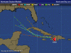
Here is what we meteorologists call the "spaghetti model", which is a misnomer. It's not one model, but plots a combination of track outputs from various models. The National Hurricane Center quite often "splits the difference" of these models, and issues a track that is the mean of the various models. However, if one model is shown to be outperforming another, they will weigh that model accodringly. The model with the best historical track record recently is the GFDL. That's the green line on the below graph. If you go to the parent website, you can scroll over the lines, and it will tell you the projected storm information, such as lat/lon, windspeed, and strength. I can tell you that the last plot on the GFDL- the one south of New Orleans- has the storm with sustained winds of 140 mph, which is a category 4 storm! While this is too early to tell if this will actually materialize, you can see why weathermen are concerned about this storm...
 

Attachments

  • spaghettimodel1.GIF
    spaghettimodel1.GIF
    32.5 KB · Views: 130
Hurricane to hit near NO right before Republican convention.

... heh
 
But the best odds do seem to be of a TX or LA landfall. Damage to NOLA being a distinct possibility, though it's still far too early to say.

Bear watching, but not panicking. Yet.
 
True, Oda. Here's my concern: the Gulf of Mexico has sea-surface temperatures in excess of 30 degrees Celsius, ahead of the projected path of Gustav.
 

Attachments

  • gulfmex_sst.gif
    gulfmex_sst.gif
    30.8 KB · Views: 76
NOAA is responsible for the entire Atlantic basin.

And yeah, the SST in the Carribeans and the Gulf are pretty scary. IF this thing stays on its current forecast track, or close to it? It has every reason to get to Category 5. And almost no possibility of not kicking someone up the...
 
2008_07L_5-day_track.gif


Uh-oh.
 
My reaction to that map sounded more like "Holy mother of..."

Seriously? If I were the mayor of NOLA, or the governor of Louisiana, I would be reviewing emergency and evacuation plans about, oh, *right now*.
It's still a little too early to panic, but if that track holds you'll want to start pulling people away a good bit before that thing hit on Monday. Saturday at the latest, I think.
 
What if you were the mayor of Mobile, Alabama? And saw this?
 

Attachments

  • al072008_20080827150108.gif
    al072008_20080827150108.gif
    47.1 KB · Views: 147
Back
Top Bottom