Hey, virtually all my posts were about the Danube serving as a sort of natural border ")
Edit: reposting Winner's last post cause it had new map info and was in the last page:
Edit: reposting Winner's last post cause it had new map info and was in the last page:
(I wish certain people in this thread at least looked at the maps carefully before posting. You'll know whom I have in mind.) And a supercomputer to model billions of years of geologic historyComplete realism is by definition unachievable, you can only approach it. What I meant is by no means that I am at all very good at it. I just try to avoid the most common idiocies I see in random fantasy maps ("I need a desert next to a swamp so that my hero can do X - why the hell not!"
) Sigh. The point of this thread is to deduce the method he used; obviously he wouldn't have bothered if they draw the circles at random. Already explained: Everything
I believe the White guy is as American as it gets. No? I'd say they're pretty similar to the mountains of Wales. You don't need Himalayas to create a region of fractured petty kingdoms (you don't need mountains at all, I might add - a large, thinly populated country with a lot of bogs and marshes and unfertile plains will also tend to produce a similar thing). In the end, each valley ends up having its own petty king, who occasionally conquers the neighbouring valleys to pronounce himself the high king, only to die and have it all split between his sons. Rinse and repeat. What?
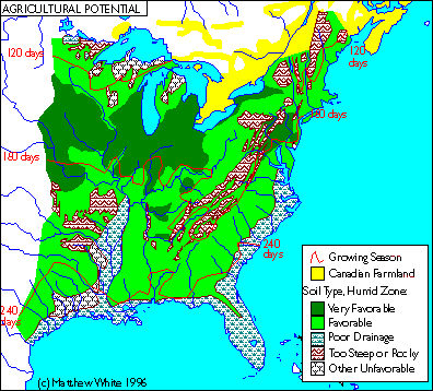
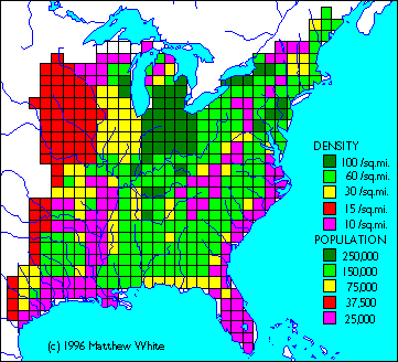
Coastal marshlands are shown on both maps. In the American one (the one White clearly put more effort into) shows the coastal marshlands in the American south as a major factor. He's got a map showing population density somewhere, which is pretty consistent with it.
 The "especially" part is important. What White does in his project is to make a slightly tongue-in-cheek representation of America after the industrial civilization fell. The parallels with the fall of Rome abound. Now, eastern US is now pretty deforested, pretty much like Roman-controlled Europe was (not to such extent though due to the much lower Roman tech-level). Following the collapse of modern civilization and the loss of 4/5ths of the US population to famine, disease and war, some reforestation would have occurred, especially in those area which are too difficult and/or dangerous to till. The European map probably refers specifically to high/late Middle Ages, since that's roughly the tech level of White's medieval America. --- Overall, I am dismayed by the level of hostility some people show to something so harmless - nobody is making this a new textbook rule or pretends to have a "skeleton key to history". It's just an interesting way of looking at things and I am interested in it only because it might be useful outside the field of history. There's no need to unleash the full academic hair-splitting fury against it. Practically anything can be ground into dust in this way and it is not helpful. --- @Kyriakos, Domen I appreciates inputs ON TOPIC. If you want to discuss Byzantine Empire and/or Poland, please do it somewhere ELSE. Thank you.