Robert Can't
Éponine
Its Argentina!
Damn, why is always Peru drawn wrong? It isn't too big.

Sorry, couldn't resist.


Yes. Yes it would.That would make for an interesting IOT
")
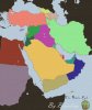
Not too sure what you mean here. Yes, it's a modern Middle East map. No, South Sudan is not in the middle east, even though Sudan is. Yes, the border is quite ugly, as I had to draw it in myself.South Sudan?

I found a blank map of Victoria 2 on Paradox Forums. There are some words on the bottom left, but that isn't too hard to remove.
Spoiler :