Nice weather all week if a bit on the cool side (temps in the 80s)
You are using an out of date browser. It may not display this or other websites correctly.
You should upgrade or use an alternative browser.
You should upgrade or use an alternative browser.
Oh, the weather outside is...
- Thread starter Valka D'Ur
- Start date
Zkribbler
Deity
Wind, rain & gloom...looks like for at least until the end of the month. 
My wife's goal is to not turn on the furnace until November 1.Sunny but a high of only 61F: I am NOT turning on the furnace today - I'm just giving it an extended checkout to make sure its working for when its really needed!

aimeeandbeatles
watermelon
- Joined
- Apr 5, 2007
- Messages
- 20,112

I think Nova Scotia might've ticked off some deity this year.
Sunny but a high of only 61F: I am NOT turning on the furnace today - I'm just giving it an extended checkout to make sure its working for when its really needed!
16 C? I take it that's almost winter weather in Arizona.
hobbsyoyo
Deity
- Joined
- Jul 13, 2012
- Messages
- 26,575
It has started to clear out here but there's enough smoke in the air that my allergies have been haywire off and on all week.The sky out here (New England) is completely overcast, despite doppler radar showing that we should have clear blue skies. The reason??
The smoke from the west coast wildfires have traveled all the way to east coast... a distance of 3000 miles covered by wildfire smoke. I didn't believe it until I actually looked it up myself.
It really is the apocalypse
Lexicus
Deity
It has started to clear out here but there's enough smoke in the air that my allergies have been haywire off and on all week.

wack
The smoke finally cleared out here, at least for the most part. I think there is still some of it in the sky because it was glowing very strangely at sunset. But I could see almost the normal amount of stars outside tonight. I haven't been able to see more than a few for several days.
aimeeandbeatles
watermelon
- Joined
- Apr 5, 2007
- Messages
- 20,112
I think Nova Scotia might've ticked off some deity this year.

Keep going east! east!!!
Darsnan
Emperor
- Joined
- Sep 12, 2007
- Messages
- 1,335
16 C? I take it that's almost winter weather in Arizona.
Actually the wife and I aren't in Arizona anymore. I went back to Syracuse to say goodbye to our cat (Nutmeg, if you follow the Cats and Kittens thread), and the wife completed her assignment in Arizona and moved north on to an assignment in Oregon. First attempt to rejoin the wife in late August lasted all of 15 seconds into takeoff roll as my flight took a bird to the engine, end result with the flight being canceled. Second attempt got nixed when the area my wife is in (Springfield, Oregon) went under evacuation orders because of encroaching wildfires. Third attempt is now scheduled for October 10th, so until then I'll be reporting weather from Syracuse (or Syberacuse, as it may).
D
hobbsyoyo
Deity
- Joined
- Jul 13, 2012
- Messages
- 26,575
The winds shifted and have brought the smoke and pollution back to my neck of the woods. Before I even looked at the local air quality index I knew things had changed as my nose started running yet again. Here's to yet another week spent completely indoors. 
This is becoming a new normal for California. Every year the fires get worse and have a bigger impact on my daily life even if my own house isn't burning down. I wonder if we'll reach a state in the next decade where the wildfires stop because everything has burned and the soil is so disturbed that between the burning and never ending droughts, nothing grows.
This is becoming a new normal for California. Every year the fires get worse and have a bigger impact on my daily life even if my own house isn't burning down. I wonder if we'll reach a state in the next decade where the wildfires stop because everything has burned and the soil is so disturbed that between the burning and never ending droughts, nothing grows.
aimeeandbeatles
watermelon
- Joined
- Apr 5, 2007
- Messages
- 20,112
Keep going east! east!!!

I'm glad I'm not in Cape Breton or Newfoundland.
aimeeandbeatles
watermelon
- Joined
- Apr 5, 2007
- Messages
- 20,112
Now it's swinging back west:

The end of summer has brought cool weather way faster than it usually does. Following on a summer that was way hotter than it usually is. But the constant has been dry to the point where we're officially in drought now. Nothing's growing, and leaves and acorns are falling early for lack of rain.
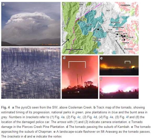
Historical weather, but I needed somewhere to put this. I just found out the fire tornado (firenado), a cloud-connected fire-generated tornado recorded in Canberra in 2003, was way bigger than I'd thought. Rather than a fire whirl, a swirl of fire connected to the ground, this was either an FE2 or FE3 tornado, strong enough to snap trees and pick up a car, and 450 metres at the base. Caused entirely by fire.
https://wildfiretoday.com/2012/11/24/documented-fire-tornado/

It luckily cut its swathe across the ridge to the south of a suburb instead of ploughing through it, because nothing in this city is build for tornadoes.
Paper here from ACT Emergency Services describes some of the evidnece for the scale and impact of it.
https://wildfiretoday.com/2012/11/24/documented-fire-tornado/
It luckily cut its swathe across the ridge to the south of a suburb instead of ploughing through it, because nothing in this city is build for tornadoes.
Paper here from ACT Emergency Services describes some of the evidnece for the scale and impact of it.
Photogrammetric analysis
As the tornado approached the urban edge, two key pieces of photographic evidence were captured by members of the public. Firstly a resident of the suburb of Wanniassa (Mr Jim Venn), took a photograph of the vista from his back deck. Analysis of this image revealed a clear image of the tornado (Figure 4e).
Photogrammetric analysis revealed that the line of sight to the tornado intersected the mapped damage path at only one location. It was thus possible to derive an accurately timed location of the tornado, and subsequently to estimate the basal diameter of the tornado at 450m. This estimate is consistent with the damage at the same point seen in post-fire photographs taken by air observers.
Secondly, a resident of the suburb of Kambah (Mr Tom Bates) took a three minute video of the tornado 82 passing north of Mount Arawang. Some still frames from the Bates video are shown in Figures 4d & 4f. Considerably more information was derived from this second case. After precisely locating the point from which the tornado was filmed, photogrammetry allowed the tornado to be traced along the mapped damage path for nearly 2 km over 3.3 minutes, at the end of which the basal diameter had shrunk to an estimated 160m.
The visible core is clearly seen to be rotating clockwise in plan view with a ground speed of approximately 30 km h-1 and a vertical velocity of approximately 250 km h-1 . Large debris, considered to be the 8 tonne roof of a water 88 reservoir, can be seen falling from the sky over 1 km from the vortex.
The Bates video also shows detail of the development of a number of spot on the lee-face of Mt Arawang. Their development is consistent with them being drawn into the air flow of the approaching tornado. At one point all image pixels covering unburnt parts of the hillside saturate, suggesting a landscape-scale flashover event covering around 120ha (Figure 4f). The observation is consistent with the ignition of a premixed fuel-air 93 composition that rapidly burns without igniting the surface fuels on the hillside (Arnold and Buck 1954; Dold et 94 al., 2005).
Damage observations
Two reports from members of the public and emergency service personnel are particularly useful for estimating the intensity of tornado. Firstly, a trailer behind an 8 tonne fire tanker was lifted off the ground, and secondly, a 2 tonne police car was picked up and dropped into a stormwater drain. The police car also had its beacons and other external attachments stripped by the strong winds. Schmidlin et al. (undated) conclude that vehicles are rarely tipped over in F2 damage and about one in five are tipped over in F3 damage. The Enhanced 101 Fujita Scale (Wind and Science Engineering Centre, 2006; NOAA, 2011) indicates that a tornado of EF2-EF3 102 intensity is required to lift and throw heavy cars.
The windthrow observed within the Pierces Creek plantation also provides a way of classifying the intensity of the tornado. Softwood trees such as pines, will have their trunks snapped when subject to winds with a mean three-second gust speed of approximately 170-180 km h-1 (see Wind & Science Engineering Centre, 2006: 106 Appendix C). This is again consistent with a tornado intensity of at least EF2. More generally, houses in Lincoln Close, a street on the edge of the suburb of Chapman, suffered a mix of damage types (Figure 5). Some houses were destroyed by fire, some exhibited only wind damage, some were burnt then damaged by wind, while others suffered wind damage and then were burnt (Webb et al. 2004).
The weight of data thus suggests that the tornado on 18 January 2003 was at least an EF2 event, but as most of the clear damage indicators occurred shortly before the tornado decayed, it is possible that it could have been rated as an EF3 event at its peak intensity
Last edited:
aimeeandbeatles
watermelon
- Joined
- Apr 5, 2007
- Messages
- 20,112

Zkribbler
Deity
aimee, are you located somewhere safe from the coming storm surge? 
aimeeandbeatles
watermelon
- Joined
- Apr 5, 2007
- Messages
- 20,112
I'm inland, well as "inland" as its possible to be in N.S.
aimeeandbeatles
watermelon
- Joined
- Apr 5, 2007
- Messages
- 20,112
I don't think there's anywhere in Nova Scotia where you can get more than 50 km away from an ocean.
Similar threads
- Replies
- 121
- Views
- 3K
- Replies
- 81
- Views
- 2K