You are using an out of date browser. It may not display this or other websites correctly.
You should upgrade or use an alternative browser.
You should upgrade or use an alternative browser.
Altered Maps 4: Partitioning Eastern Europe Like In The Good Old Days
- Thread starter holy king
- Start date
- Status
- Not open for further replies.
Winner
Diverse in Unity
Here's another part of my Hadj Pandemic scenario, this time dealing with the post-pandemic Middle East:

---
Hadj Virus caused one of the worst cases of depopulation in human history in the Arabian peninsula, mainly because the whole area simply couldn't support those who recovered from the infection itself. Once the law and order had broken down, imports of food and fresh water (not to mention other supplies) ceased. The US had to evacuate its military bases which were flooded by thousands of desperate refugees. Once the Western forces left, the region was left to fend for itself. Soon, all communications with the affected countries ceased and it was not until few years later that the West learned what happened. Until then, only the satellite pictures of burning cities, oil wells and exquisite tourist resorts provided the rest of the world with hints of the fate of this formerly rich region.
Other parts of the Middle East suffered too. In Israel, the disease spread rapidly among the Palestinians in overpopulated Gaza and on the West Bank. Israeli authorities imposed total quarantine, but the disease couldn't be stopped and it soon began to spread in Israel proper. Only strict measures (such as airtight quarantines imposed on infected communities, curfews, bans on travel etc.) imposed by Israeli military prevented a total collapse of the State of Israel, but this came at the cost of Israeli democracy which gave way to a period of military rule. Palestinians were less fortunate - the collapse of the remnants of Palestinian Authority, termination of foreign aid programs and Israeli restrictions caused a massive loss of life: whereas in Israel proper the death rate reached about 30%, in Palestinian territories it was over 70% (in Gaza 99% of people died).
When the pandemic finally ended, all countries were massively damaged and only few could maintain some sort of control over their territory. In the end, only Israel, Turkey and Iran survived with their governments still functioning. When the immediate problems concerning food supplies, law enforcement and medical assistance were solves, these countries began to assert control outside their pre-pandemic borders.
Turkey: seized parts of Syria, but largely lost control over the Kurd areas in the south East. Surprisingly, the Kurds managed to weather the pandemic with lesser death rate than their neighbors, mainly due to possession of prime farmland. Once the epidemic abated, they realized they've been given a unique opportunity to throw off the shackles of foreign oppression and they took it. Currently, a loose confederation of Kurdish communities maintains control over large parts of Turkey, Iran and former Iraq. It is rumored that the Kurds are receiving military aid from Israel, which wants to use them as a "firewall" against Turkish and Iranian expansion.
Iran: although the country nearly collapse due to massive loss of life, the Islamist regime proved more resilient than expected. After it restored over in most of the country (except the Kurdish areas), Islamic Revolutionary Guards began entering Iraq and seizing its deserted territory. Iranian expansion was stopped in the south by arriving American forces.
Israel: The military government, once it took full control of the country, didn't waste time trying to seek legitimacy for its actions. In fundamentalist circles, the pandemic was seen as a God's gift to Israel, a purifying flame which enabled Israel to fulfill its destiny. Since there was no functioning government in Syria, Egypt, Jordan and Lebanon, Israeli forces entered these countries and annexed them whole or in parts, including Sinai, Lebanon, parts of Syria, Jordan and Saudi Arabia. At the same time, relocation zones were set up and the surviving Arab population in what was now Greater Israel was transfered to these areas. Swathes of free land attracted many Jews from America and Europe to move to Israel and Jewish settlements soon began to pop up in ex-Arab areas. Despite these successes, there is a growing unrest among native Israeli who want to restore democratic civilian rule in the greatly enlarged country.
Armenia: Armenians took the opportunity and captured large parts of Azerbaijan, which was unable to properly defend itself during the pandemic. Turkey was unable to intervene either due to the pandemic chaos and war against Kurdish insurgents.
Besides them, three foreign powers entered the region:
USA: In order to secure oil supplies, American forces moved to occupy large portion of the Persian Gulf and Saudi Arabia (including the city of Mecca, which caused outrage in the remnants of the Muslim world).
China: Chinese arrival was a shock to the US because US secret services completely failed to spot the preparations and departure of the invasion fleet. Fortunately for Americans, most important parts of Arabia were already taken, so China had to settle for Oman and parts of Yemen. Still, some important oil fields are now controlled by China and the tensions between it and the US are growing.
EU: European presence in almost totally depopulated Egypt is limited to coastal cities and the Suez Canal, which was included to one of the EUSAF zones of control after a secret deal with the Israeli government. Number of illegal settlements in Nile Delta is growing, but not so fast as in other parts of North Africa, mainly due to unsanitary conditions and great damage to infrastructure caused by massive flooding which followed the collapse of the Aswan Dam.
I'd thought the Clerical regime in Iran would collapse in the wake of such an epidemic.
By the way, what happened in India and Indonesia? Both are densely populated nations (Java in Indonesia's case) with very large Muslim populations (more in Indonesia's case)
By the way, what happened in India and Indonesia? Both are densely populated nations (Java in Indonesia's case) with very large Muslim populations (more in Indonesia's case)
Winner
Diverse in Unity
I'd thought the Clerical regime in Iran would collapse in the wake of such an epidemic.
I'd say people would turn to religion even more in such situation, which could favor the radical elements of the regime.
By the way, what happened in India and Indonesia? Both are densely populated nations (Java in Indonesia's case) with very large Muslim populations (more in Indonesia's case)
The virus doesn't care about people's religion
")
Spoiler :

India struggles to stay in one piece and the same applies to Indonesia; there is chaos and a lot of internal fighting which consumes their all governments' time and energy.
MagisterCultuum
Great Sage
There are Hispanics of Asian descent. Not a ton, but they're out there!
I know a couple Korean Americans that were born and raised in Brazil, and speak Portuguese slightly better than English or Hangul but are completely Korean genetically. Would they count as Hispanic Asians?
Heretic_Cata
We're gonna live forever
Wait how does Iran have cases of AIDS, the ayatolah said there are no gays thereDamn, we need more nuclear power plants. 40% of electricity from n.p. isn't enough.
---
HIV/AIDS infection in the world:
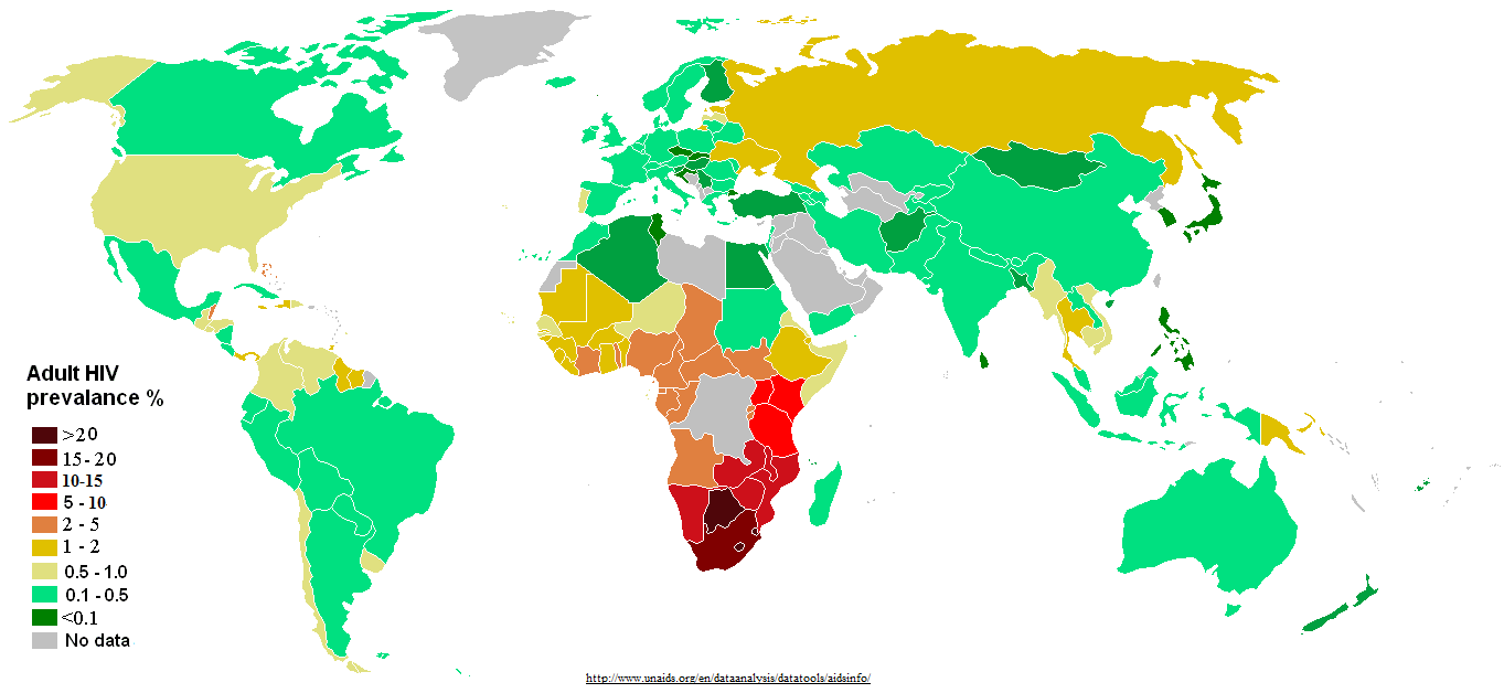

North Korea seems a bit low for a country in such piss-poor shape, but maybe that has to do with the closed borders.
The Islamic Countries being low doesn't suprise me, but the reason why they're low isn't necessarily good.
The Islamic Countries being low doesn't suprise me, but the reason why they're low isn't necessarily good.
Gelion
Retired Captain
North Korea seems a bit low for a country in such piss-poor shape, but maybe that has to do with the closed borders.
The Islamic Countries being low doesn't suprise me, but the reason why they're low isn't necessarily good.
I am more surprised about Spain and Switzerland than North Korea and Islamic states.
Winner
Diverse in Unity
I am more surprised about Spain and Switzerland than North Korea and Islamic states.
Aren't you from Russia and aren't you also living in Switzerland at the moment?
Spoiler :
Bad joke, sorry
---
I am always a bit skeptical about the data coming from countries which have every reason to alter the statistics in order to avoid looking hypocritical, which applies to Iran and other not-so-democratic conservative countries.
Gelion
Retired Captain
Yeah, and my last date was from SpainAren't you from Russia and aren't you also living in Switzerland at the moment?

I am not sure. Most of those countries have sufficient medical system and combined with strict social norms could work well in stopping the spread of HIV.I am always a bit skeptical about the data coming from countries which have every reason to alter the statistics in order to avoid looking hypocritical, which applies to Iran and other not-so-democratic conservative countries.
Winner
Diverse in Unity
Yeah, and my last date was from Spain
Did she bring a Portuguese friend to make the evening more interesting?
I am not sure. Most of those countries have sufficient medical system and combined with strict social norms could work well in stopping the spread of HIV.
Maybe, I don't know.
Azerbaijan is a Turkic country with Islamic heritage.
So's Tatarstan, but you're including Russia.
A typical US loses the Civil War map:
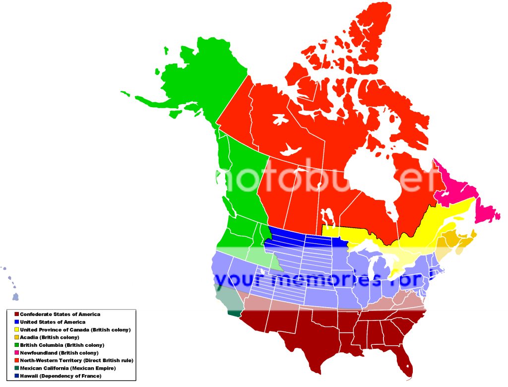
I did have this time-line plotted out right through to the '90s, but this is the best remembered (somewhat written down), and most logical, part.
Spoiler Timeline summary :
OK, let me preface this by saying all the groundwork was laid about 10 years ago, so a number of aspects have been lost or become muddy. As such I have had trouble figuring out a whole story that makes any sense, and as I was about 10 when I made this story up, historical accuracy is not guaranteed.
A basic summary of the events leading to this map:
There was no Battle of Gettysburg (as we know it)
o Confederates withdrew, but successful rear-guard actions caused many casualties helped decrease Union morale.
Due to the efforts of pro-Confederate individuals (who began operating well before the war) the New York Draft Riots were more significant.
o Rioters were better armed, allowing them to seize the Tribunes Gatling guns and the armoury.
o Leadership by the pro-Confederates helped keep the focus as an anti-federal riot, not anti-black and immigrant.
o Combined to cause a major battle for the city.
o Union troops firing on a group of women and children cause widespread riots in the North.
These things combine to drag on the war until 1865 when France and England recognize the Confederacy and join the war (the Union followed through with its threat to declare war hoping others would join them against the Anglo-French Alliance).
British surprise attack takes New York City, and besieges Boston, and gives them free range in the North-East.
o The Royal Navy then moves South to join the French and Confederate fleets in destroying the Union blockade.
Union attempts an offensive-defence, taking British Columbia and Upper Canada, the latter of which suffers a brutal occupation.
The eastern part of the Union is slowly occupied until only Philadelphia (where the government is) remains.
The siege of Philadelphia lasts over a year as Western forces amass and march to break the siege, but are defeated. Philadelphia and the US government surrendered in late 1869.
France and the UK are protected in Europe by a series of diplomatic pacts for the duration of hostilities.
Spoiler Map explanation :
In the final Treaty of Halifax, the United States acknowledged the independence of the Confederate States of America. With this came several territorial changes (in addition to recognizing the secession of the Confederacy and its two claimed territories.
The CSA annexed West Virginia, claiming that Virginia seceded to them as a whole, and those in the west had no right to break off of Virginia and was illegally incorporated as a state.
Kentucky was given the option, through a referendum, to either remain with the Union or join the Confederacy. Large portions of the pro-Union population evacuated the area along with the Union Army during its retreat and were prevented from returning prior to the referendum. At the same time, a significant number of confederate soldiers and camp followers were in Kentucky at the time and took part referendum. This vote was contested as illegitimate, but the Union was in no position to take action.
A southern strip, south of the 37th parallel north of Missouri was also annexed to the State of Sequoyah. Statehood was granted to the Indian Territory and citizenship extended to all of its inhabitants, in 1864 to help appease the Confederacys native allies and create unrest amongst those in the North. While the Confederates wanted the entirety of Missouri, military leaders did not want the bulge in the border and diplomats saw the need to appease the Union in some ways.
The Confederate Arizona territory was expanded northwards to encompass all territory south of the 37th parallel and east of California. It became a state as many soldiers were given land grants in the area along with people choosing to leave Union border areas and Mexican California to join the Confederacy.
That constituted the entirety of the Confederate States of America, although the Union lost significant lands to other parties involved in the war. These lands were annexed primarily for political reasons to appease the people back home and show gains from the war.
The border on the 37th parallel was further extended through California and all land south of it was annexed to Mexico. The border was chosen primarily for simplicity since the annexation was orchestrated by the French in order to appease Mexicans with their newly installed emperor. Americans in the region were forcibly ejected into either American California or the new Confederate State of Arizona.
There were also significant losses of territory in the north to Great Britain. These annexations were largely spurred on by the local population of British North America, particularly those in Upper Canada who suffered from brutal campaigns soon after the British declaration of war, as well as British Columbia and Ruperts Land which were occupied by Union forces.
Most obvious is the renunciation of the Oregon Treaty of 1848. The British reasserted its old claims to the Oregon Country and annexed it to British Columbia. This appeased many from British Columbia who saw opportunity in these lands.
The British also renounced the Webster-Ashburton Treaty, annexing the north-eastern tip of Wisconsin to Ruperts Land and northern Maine to New Brunswick.
Meanwhile the rest of Maine was annexed, and secured for Britain by giving Mainers land to the North, and resettling the new land primarily with veteran British soldiers.
These events created the new United States of America, whose capital still officially resides in Washington DC, but except for ceremonial purposes most government work is carried out in New York City, which survived the war largely intact, unlike other cities, such as Boston and Philadelphia, that suffered devastating sieges. There is discussion to transfer the District of Columbia to Maryland and create a new federal district for the capital.
With the continent reorganised after the war, many changes soon followed outside the former United States:
In 1871, the British purchased Alaska from Russia. Already suffering economic difficulties Russia attempted to gain revenge on Britain and France for the Crimean War by providing material support for the Union through occupied British Columbia. Russia concluded a deal very favourable to Britain (about two thirds what the US paid) to improve relations and hold back a desperate economic situation. This territory was promptly transferred to British Columbia to establish one large Pacific colony. Though they saw little value in this land, it was viewed as a potential strategic liability in the future if it fell into the hands of Prussia, the USA (who had previously negotiated about its purchase), or the CSA.
In the eastern Maritimes, the British, looking back upon the union of the Canadas decided to put its eastern colonies under a central government in Saint John. This new Province of Acadia consisted of Prince Edward Island, Nova Scotia, the expanded New Brunswick, and newly acquired Maine.
With settlement increasing in the west south of Lake Winnipeg, the British decided to extend the Canada West to control this area, establishing northern and western borders similar to the original Manitoba. The territory annexed west of Lake Superior was also added to Canada West.
Ruperts Land and the Arctic Islands were also formally incorporated into the North-Western Territory, though this had no actual impact.
By agreement with the French regarding their intervention, the British aided the French in securing Hawaii, though the King nominally remained in power.
As to the map itself:
The base map does have significant flaws
Not to mention my border drawing skills are horrendous
Some borders are wrong:
o Some places may have slightly different boundaries since this is based on a modern map (white lines are modern borders).
o I think the map I got the British Columbia boundaries off of was flattened too much, and the tip should be further west, but the best maps all cut the tip off.
o Canada West's border is rather inconsistently drawn, so I went with a reasonable border until the modified parts.
o Labrador is often shown as just the coast on period maps, but also shown in full size (depending on who made the maps, since Quebec. and its predecessors, claimed the interior). I went the easy, and technically correct, way.
US territory with lines are territories.
All British colonies, except teh newly expanded North-Western Territory have responsible government.
I did have this time-line plotted out right through to the '90s, but this is the best remembered (somewhat written down), and most logical, part.
 What was the PoD, headcrab zombie pods bombard New York City?
Weik
Warlord

The Europe of Ethnic groups.
As it appeared on the maps as drawn by the non-Germanic clan of the WaffenSS, which became a majority in 1945. In the mind of this organization, each province – after the return of the Jews in Palestine or somewhere else – would receive its total cultural autonomy and would stay dependent of the federation for economy, foreign policy and defense. At the top level, composed exclusively of men having acquired their merits in WW2 battles, and born in each province of which they would be responsible, the powers of decision and orientation depended only from the SS, federative power and responsible of the “becoming” of the continent, which central seat would have been Vienna or Prague. The Eastern land, up to the Bering Straight, was considered a colony in the developing stage.
For the SS it was to go from the ethnic notion to the race notion, through a genetic policy aimed at developing what it considered superior races: Nordic, Germanic, Celtic and Alpines.
It is curious to notice that, 30 years later, some movements which are not “neo-nazis” – quite the contrary – propose maps looking about the same. The idea of federation succeeding to the historically founded, but overcomed by evolution, nationalisms is now floating in the air, even in France, a Jacobin nation by excellence, and prefigures perhaps some ethnic division, closer to the nature of man than the maintenance of purely linguistic communities.
Mirc
Not mIRC!!!
Not found on this server?
Winner
Diverse in Unity
Huh, when was the map made? Why is East Prussia and the Baltic countries (and others) not included? I don't get it - is it serious, or some kind of a joke?
Gelion
Retired Captain
Huh, when was the map made? Why is East Prussia and the Baltic countries (and others) not included? I don't get it - is it serious, or some kind of a joke?
The borders surely date from 1945-1990....
- Status
- Not open for further replies.
Similar threads
- Replies
- 505
- Views
- 26K
- Replies
- 64
- Views
- 5K
- Replies
- 0
- Views
- 185
- Replies
- 2
- Views
- 545