You are using an out of date browser. It may not display this or other websites correctly.
You should upgrade or use an alternative browser.
You should upgrade or use an alternative browser.
Altered Maps XVIII: Continuing Curious Cartography
- Thread starter amadeus
- Start date
danjuno
Cole Phelps, Badge 1247
I wouldn't be a CivFanatic if I didn't keep this thread going!

Relative change in national identity in Northern Ireland between 2011 and 2021 censuses, per Wikipedia.
Relative change in national identity in Northern Ireland between 2011 and 2021 censuses, per Wikipedia.
What is the big white spot?
Lough Neagh, a lake.What is the big white spot?
Last edited:
Knowing some traditional Irish folktales, that's probably the actual explanation! They're actually not that far apart in size - Lough Neagh appears to be about two-thirds the size of the Isle of Man.
Brilliant Maps - Making Sense Of The World, One Map At A Time
Making Sense Of The World, One Map At A Time
 brilliantmaps.com

This time of the year the sun sets in Eastern Brazil before it sets in Ireland, Scotland or Norway.
To really appreciate this you need to see the videos, but we cannot link them here. If you head over to https://svs.gsfc.nasa.gov/5552/ you can see it animated, and it looks quite cool.
Simulation of atmospheric aerosols in our intricate Earth system.
Sea salt (cyan), dust (magenta), black carbon (orange/red), and sulfates (green)
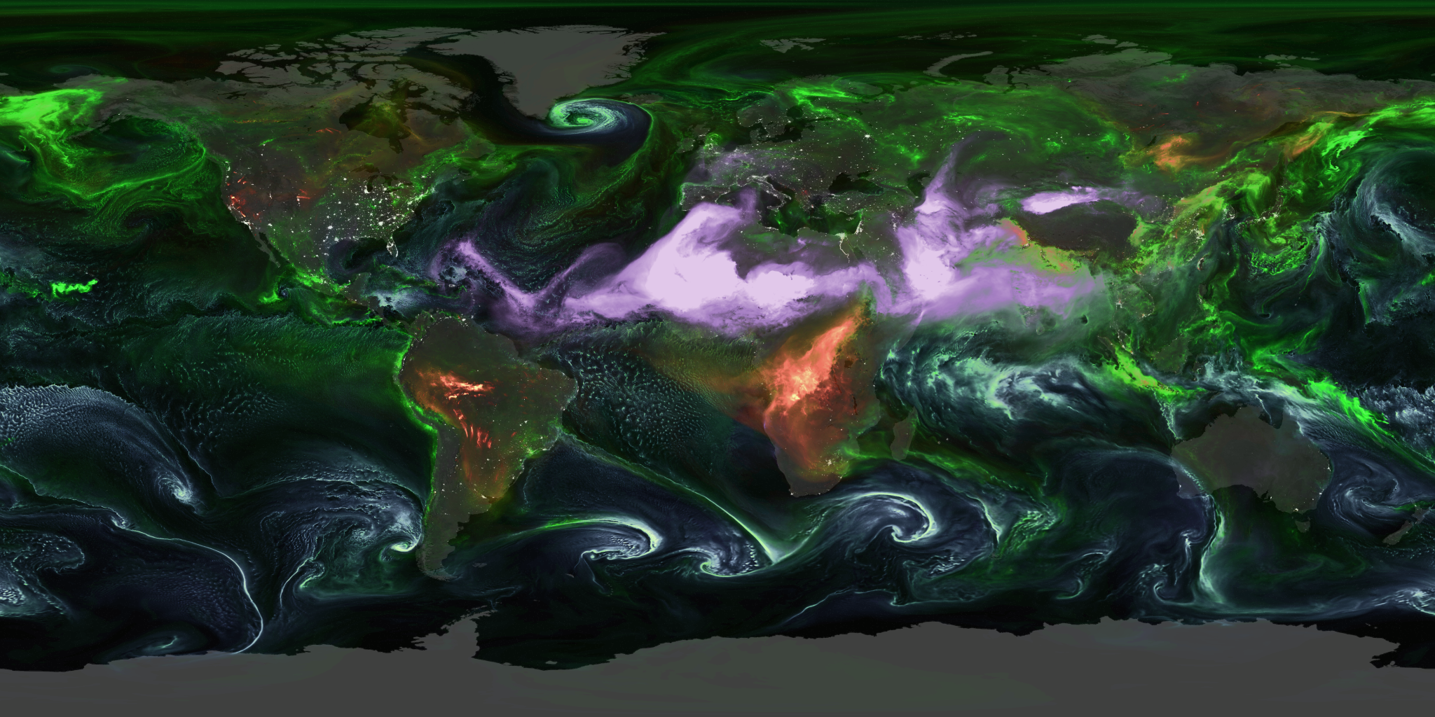
Simulation of atmospheric aerosols in our intricate Earth system.
Sea salt (cyan), dust (magenta), black carbon (orange/red), and sulfates (green)
Awesome link!
banzay13
Emperor
Wonder, then whole Africa became Red 

Thorgalaeg
Deity
Very very detailed comprehensive map of Spanish exploration of North America.

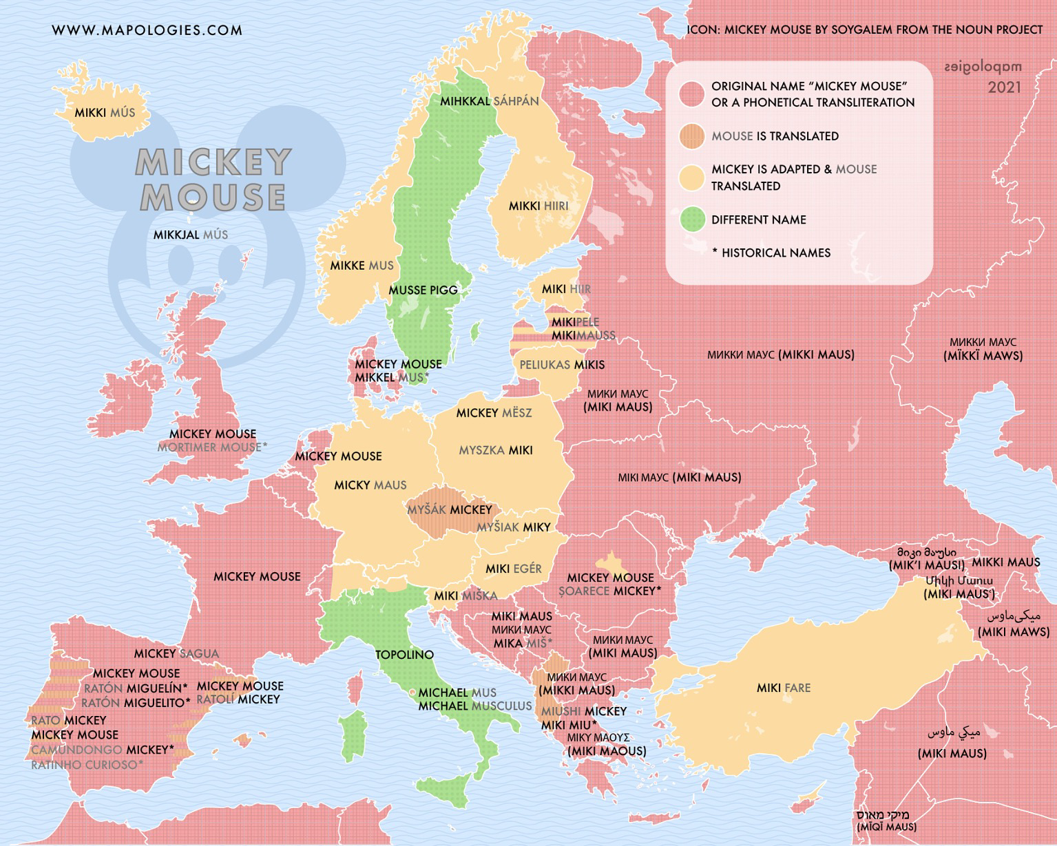
Is there on the planet someone who does not call him Mickey Mouse? Well, it does. In many cases, languages choose to adopt the name Mickey phonetically: Miki. Much better! Some even dare to do it with his surname “Maus”. However, in German, it is not, it the translation of mouse. So it does Czech Myšák, Hungarian Egér, Finnish Hiiri, or Turkish Fare among others.
Bonyduck Campersang
Staring into the distance
- Joined
- Dec 11, 2022
- Messages
- 4,783
tjs282
Stone \ Cold / Fish
Adidas is a religion now?
In the name of the Sneaker, the T-shirt, and the Holy Shorts?
In the name of the Sneaker, the T-shirt, and the Holy Shorts?
danjuno
Cole Phelps, Badge 1247
Estonia is majority Shinto? Are there a disproportionate amount of weebs over there?
I could tell it was AI slop before I saw the name of the OOP.
I could tell it was AI slop before I saw the name of the OOP.
Last edited:

Similar threads
- Replies
- 1K
- Views
- 96K
- Replies
- 1K
- Views
- 108K
- Replies
- 1K
- Views
- 131K