This map is from the Chinese forum of DoC (http://tieba.baidu.com/p/3509120712)
I think, the best I can decipher, they are discussing about China border and China's city names.


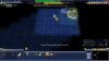
Red Squares represent the city names, grouped with the similar name.
Green shaded area is China's core area
Yellow shaded area is China's historical area
Red continuous line represent 2015's China border (as they claimed).
I'm not sure about the red and blue dotted line, probably somebody else could transliterate, but I think:
- Blue dotted diagonal means the tile is settle-able but there's no name for it
- Red dotted diagonal means the tile is not settle-able (which is Xinjiang, Western Tibet, etc)
All credit goes to 穿着棉鞋洗脚, the creator of the map. I will remove it upon request.
They also mentioned that:
- There's no Pearl River to the south... (?)
- Why Mandalay is historical for China
- Nanning position is too deviated.
I'll see if there's anything else interesting.
I think, the best I can decipher, they are discussing about China border and China's city names.
Spoiler :
Spoiler :
Spoiler :
Red Squares represent the city names, grouped with the similar name.
Green shaded area is China's core area
Yellow shaded area is China's historical area
Red continuous line represent 2015's China border (as they claimed).
I'm not sure about the red and blue dotted line, probably somebody else could transliterate, but I think:
- Blue dotted diagonal means the tile is settle-able but there's no name for it
- Red dotted diagonal means the tile is not settle-able (which is Xinjiang, Western Tibet, etc)
All credit goes to 穿着棉鞋洗脚, the creator of the map. I will remove it upon request.
They also mentioned that:
- There's no Pearl River to the south... (?)
- Why Mandalay is historical for China
- Nanning position is too deviated.
I'll see if there's anything else interesting.

 . I.e. you still can call F1-F9 screens, but units no longer move and no other command is accepted by the game.