[Development] Map Suggestions

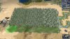
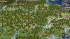
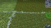
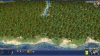
So after downloading the new taiga art I got tempted to play around some more with Scandinavia. The screenshot below also contains changes to Karelia and the Kola Peninsula made based on suggestions from Finbros in a previous post (https://forums.civfanatics.com/threads/development-map-suggestions.632861/page-4#post-15155661).

Spoiler :
done.jpg


-First, regarding forests: Yellow is taiga, blue coniferous (some cold, some green to achieve smoother transitions), red is mixed. I don't know if the mixed forest region of middle/southern Sweden should have more mixed forests; nowadays coniferous trees dominate, but I think there used to be a higher proportion of deciduous trees in the past than there is now. The unmarked forest in Scania should be deciduous. Of course, forests don't have to placed exactly like this, it is just an indication.

-Added a river below Bergen, representing the Hardangerfjord. Visually, this seems fine as Bergen is between two large fjords in reality. More importantly, it makes Stavanger 1S of Bergen a bit more reasonable. Since Stavanger is old and fairly large, having grown quickly after becoming the "oil capital" of Norway in the 70's, I think it would be nice if it was at least a somewhat decent alternative. And the oil should be reachable both from there and from Bergen.

-Made Gotland flat. While it has some fairly high areas I don't think it's enough to justify it being a hill.

-Added four marshes to central/northern Finland, where peatlands/bogs are ubiquitous. Moved the fur 1S from one of the added marshes.

-Moved the restored finnhorse 1N to make place for Åbo/Turku, which should be a viable alternative to Helsinki IMO. It's the oldest city of Finland, and was the largest and most important city during the time of Swedish rule. Helsinki wasn't important before the Finnish capital was moved there in 1812 after Russia won Finland from Sweden, and it was smaller than Åbo until the end of the 1840s.

-Replaced tundra with moorland in Finland up to the area around Lake Inari, where significant areas with permafrost start to appear in reality. The orange marking in the north encompasses the all the remaining tundra in the area (Finbros suggested replacing tundra with moorland+taiga in Karelia and southern Kola peninsula, which I fully support).

-Made some of the Norwegian islands green since I think it looks nicer.
 
Last edited:
@merijn_v1 I have found a few issues with some of the new feature art:
- there is some flickering with the new Taiga art, can you check if you notice something similar?
- while the bamboo forest art looks great, I think right now the bamboo stalks stick out too much from the other trees. I think there is too much hue in general so the contrast to the surrounding terrain is too much
- I like the taiga art but it seems a bit too extreme for all the tiles that I would like Taiga for, especially Taiga/Moorland. Maybe there should be a second variety of Taiga that is inbetween the cold forest variety and the current Taiga variety?
 
Hey, here are some ideas for additional features (all from C2C).

It has a young forest that we could use as a woodland, ie, to represent sparsely wooded areas that otherwise (ie, except for the density) the same as forests (species-wise, climate-wise, etc). Woodlands would provide less hammers than forests, and could serve as a transition between full forests and terrain with no cover.

It also has a savanna feature that looks different than the one we have here. The one in DoC is all palm tress, the one in C2C is both palm trees and some broadleaf trees. It would be nice to include it as a graphical variety of the savannas we have here, as it looks better for mediterranean forests (for example) as well as for temperate savannas (the palm trees on their own look great for tropical areas).

There are also three cactus features (they're three different graphical varieties), that would be really nice to add as a new type of feature (shrublands) to use in deserts and semideserts.

Those cactus features graphically include some cacti and some shrubs and tall grasses, we could also mix it in with some palms and broadleaf trees (the savanna feature), and remove the cacti, and then I think that would look perfect as Mediterranean forests and/or Spiny forests (like the Caatinga in Brazil, they exist also in Southern Africa, Australia, etc).

For water tiles, they also have coral reefs, seagrasses, and kelp beds, which all would make nice additions to increase food and commerce.
 
Last edited:
@merijn_v1 I have found a few issues with some of the new feature art:
- there is some flickering with the new Taiga art, can you check if you notice something similar?
- while the bamboo forest art looks great, I think right now the bamboo stalks stick out too much from the other trees. I think there is too much hue in general so the contrast to the surrounding terrain is too much
- I like the taiga art but it seems a bit too extreme for all the tiles that I would like Taiga for, especially Taiga/Moorland. Maybe there should be a second variety of Taiga that is inbetween the cold forest variety and the current Taiga variety?

- I don't really see the flickering myself. Could it be that the waving of the tree reveales/hides some very white part of the tree behind which makes it look like it is flickering?
- I can make the bamboo less constrasting.
- Sure.
 
I uploaded a gif to illustrate what I mean, it's heavily compressed to get it on CFC but it should still show the issue:

Spoiler :
taigaglitch.gif

What I mostly mean is the tree at the cursor position, it seems to flicker between snow covered and green. It's almost as if there are two tree models from the bordering taiga and forest features overlapping here.

The other thing is that the swaying animation looks really busy. If you compare the snow covered forest variety at the bottom center of the image, that is not the case there. I wonder if something is up with the compression of the texture.
 
I uploaded a gif to illustrate what I mean, it's heavily compressed to get it on CFC but it should still show the issue:


What I mostly mean is the tree at the cursor position, it seems to flicker between snow covered and green. It's almost as if there are two tree models from the bordering taiga and forest features overlapping here.

The other thing is that the swaying animation looks really busy. If you compare the snow covered forest variety at the bottom center of the image, that is not the case there. I wonder if something is up with the compression of the texture.

I recreated the situation and I have it too. It is indeed 2 models overlapping. Unfortunately, there is not much I can do about it. When having two different features (or even varieties) next to each other there is always a chance that the models have overlap. I replaced the taiga with leafy forests and it has the same problem. The only difference is that this isn't as noticable because the textures are pretty similar. I think that all features do have the same mechanic, but it is only a problem for the taiga because it has a noticably different texture than the other features.

I did find a workaround. If you replace one of the surrounding features with another feature or another feature variant, it will load a different model (because the forest connection between tiles is diffent) which doesn't have the overlap. The problems is solved when I replaced the taiga 1E or 1S of the cow with the (just finished) 2nd taiga variety. (Replacing the taiga 1E shifted the overlap issue to the right of this tile, but this overlap wasn't noticable because the textures of both taiga varieties are similar. In fact, both overlapping trees use exactly the same texture.)

So the problem can be "fixed" by changing the feature type or variety of the neighbouring tiles. I think changing the variety one of the taiga tiles is best because it won't look much different as both varieties look very similar.


BTW, here is a screenshot of the 2nd taiga variety. Left is snowy forest, middle is new taiga variety, right is old taiga variety.
(Giving it a second look now, I think it should have a little bit more snow to have a little bit more difference with the snowy forest.)
 

Attachments

  • Civ4ScreenShot0213.JPG
    Civ4ScreenShot0213.JPG
    536.1 KB · Views: 190
Retextured bamboo. (The old art is in the box for comparison)

Seeing the difference, the less contrast is indeed much better.
 

Attachments

  • Civ4ScreenShot0215.JPG
    Civ4ScreenShot0215.JPG
    1.2 MB · Views: 216
I like both, thanks!
 
I saw your PR, will merge as soon as the conflict is resolved. Are you interested in adding another tropical forest variety? I think you could mix the broadleaf forest tree with the leafy tree from the Savanna feature.
 
Not sure, but 50-50 seems good.
 
Finished. The first test, I noticed that the broadleaf trees had a different color than the normal one. Somehow, they were much brighter. It took a while to find the cause. DoC uses the Terrain2.fpk, which includes a new texture file for the trees, whereas I was still using the old vanilla one.

Spoiler Vanilla broadleaf trees (broadleaf on top, new tropical below) :


So I used the new texture from the Terrain2.fpk. Now the broadleaf trees have the same texture. Which one should I use? Personally, I like the new one from Terrain2.fpk better, because it blends in much better with full broadleaf forest and their is a bigger difference between the broadleaf and tropical trees. Another benefit is that this texture has more detail, although that is hardly noticable on the default zoom setting.

The bamboo forest still uses the vanilla texture. I can make that one use the new texture too, so the broadleaf trees blend in better with the full broadleaf variety.

Spoiler Terrain2.fpk texture :


EDIT:
I made a PR with the broadleaf texture of Terrain2.fpk. If you want to use the other one, I can easily revert it and use the other texture. Otherwise you can immediately merge it.
 

Attachments

  • Civ4ScreenShot0216.JPG
    Civ4ScreenShot0216.JPG
    611.8 KB · Views: 716
  • Civ4ScreenShot0217.JPG
    Civ4ScreenShot0217.JPG
    580.4 KB · Views: 725
Last edited:
Hi, quick question here regarding Sichuan (should have rice/ maybe floodplains and silk), which would be Chengdu ingame I guess.... will the new map allow it to be as populous as IRL? Because in the classic map I thought the only feasible workaround to represent that would be to change Dujiangyan into a non-expiring, +2 food per peak wonder...

Furthermore, will the Caledonian Forest be represented?
 
Last edited:
There's forest in Scotland?
 
Sorry, I meant on the map. This was confusingly phrased. The map already has forest in Scotland so what are you asking for?
 
Ah my bad, must have misremembered then - maybe on the Cow additionally?

Anyway as long as the map ensures that Chengdu or Chongqing become large population centres (the most populous provinces are Guangdong, Shandong, Henan and Sichuan) then I am OK... it has been such a pet peeve. Maybe resource placement/ terrain change could ensure that the population centre for China shifts southwards - or would running Meritocracy alone ensure that?

Also more New World food resources could spawn to simulate the Qing population explosion?
 
@Krieger-FS Are your suggestions for South America based on enlarging the continent in any way? I have started applying them and they do not seem to work out space wise. I'd rather be sure what exactly the changes entail before going further.
 
Yeah, I've made four major changes regarding the continent as whole.
The first two were actually TJDownling changes disscussed here, moving both Eastern Brazil coast and the Chilean coast 1E, giving Brazil more land at the same time mantained the continent shape The last two were made by me with ozqar suggestions. The third one was enlarging South America 1N right above Equator line to give space for a more appropriate representation of Colombia, which was made at the cost of one (of the original two) ice line in the Artic above North America. The final one was moving everything East of Magdalena river (Colombia) 1E at the cost of the enlarged French Guiana, again to properly represent Colombian territory while maintaing a reasonable continent shape.
Besides these changes, I've proposed a few water-to-land/lagoon titles changes, mostly in Brazil and Venezuela, but they did not really represent enlarging the continent.
 
Last edited:
Oh, that's too bad. I must have missed or forgotten that. I guess I will have to reconstruct what you did from scratch while keeping the continent size unchanged.
 
Top Bottom