Hurricane Ivan

Dumb pothead said:
Possibly a stupid question: Is rain from a hurricane saltier than 'regular' rain?
IIRC, it is not, however you can get sea spray from long distances which is salty.
 
Oh ok, thanks. I thought maybe alot more of the water was pulled up out of the ocean by the high winds, rather than evaporating into the system.
 
Chieftess said:
The path now looks like it's gonna hit the Florida panhandle, but affect cities in the North East later in the week. Origanally, it was to head due north like Hurricane Frances. We only got a few spurts of downpours here when it came by.

Erm, when you say Northeast cities you don't mean Northeatern US right? :twtich:
 
Dumb pothead said:
Oh ok, thanks. I thought maybe alot more of the water was pulled up out of the ocean by the high winds, rather than evaporating into the system.
I don't think this is the case, but I could be wrong. We'll have to wait for Quasar to come back.
 
Perfection said:
I don't think this is the case, but I could be wrong. We'll have to wait for Quasar to come back.
Ok in the meantime, I'll take a wild guess: Maybe its slightly more salty, but not much more. If it was alot more salty, powerful hurricanes would be a disaster for inland fresh water ecosystems, and Ive never heard of anything like that being the case.
 
When Frances came through here in Atlanta, it was a tropical depression. Rained 3 - 4 inches for 16 hours straight. Ivan looks like it will be a tropical storm by the time it gets here. Yay, fun fun. :sarcasm:
 
Hurricanes draw their energy from the humidity, or water vapor, in the air over warm oceans. All water vapor in the air evaporated from a body of water, such as the ocean, or even a dish full of water you left outside. Obviously, the oceans account for most of the water that evaporates into the air all over the world.

When a liquid, such as water, evaporates, only the liquid itself, not any solids mixed with it, such as salt, evaporates. In other words, when water evaporates from the ocean, the salts in it are left behind.

When you distill water, to make it pure, you evaporate water by heating it and catching the vapor, which you turn back into water by cooling, which causes the water vapor to condense back into a liquid.

Once a hurricane's winds begin blowing, they kick up spray from the ocean. This spray, unlike water that evaporates, is ocean water with the salt still in it. Sometimes a hurricane's winds will blow spray inland, where it can mix with the hurricane's rain, making it somewhat salty. But, this spray never blows very far inland.
 
We might be seeing this kind of graphic near American coasts in a few days:
 

Attachments

  • Ivanwind1.jpg
    Ivanwind1.jpg
    9.2 KB · Views: 105
Hot off the presses, track adjusted slightly westward...
 

Attachments

  • Ivan6.gif
    Ivan6.gif
    38.9 KB · Views: 121
Quasar1011 said:
Once a hurricane's winds begin blowing, they kick up spray from the ocean. This spray, unlike water that evaporates, is ocean water with the salt still in it. Sometimes a hurricane's winds will blow spray inland, where it can mix with the hurricane's rain, making it somewhat salty. But, this spray never blows very far inland.
Looks like you nailed it Perfection:goodjob: Argh! Am I getting dumber as I get older, or are kids getting smarter?? (waves his cane angrily)
 
HOUSTON (AP) – Reports out of Grand Cayman, which has been furiously pummeled by category 4 Hurricane Ivan overnight and throughout Sunday morning, via internet and telephone, reveal a picture of grim devastation.

So far, Ivan has caused the deaths of some 56 people in the Caribbean on its deadly rampage from the Lesser Antilles, across Grenada, on to Jamaica and now Cayman.

Yesterday the Governor of the Cayman Islands, Mr. Bruce Dinwiddy, declared a State of Emergency.

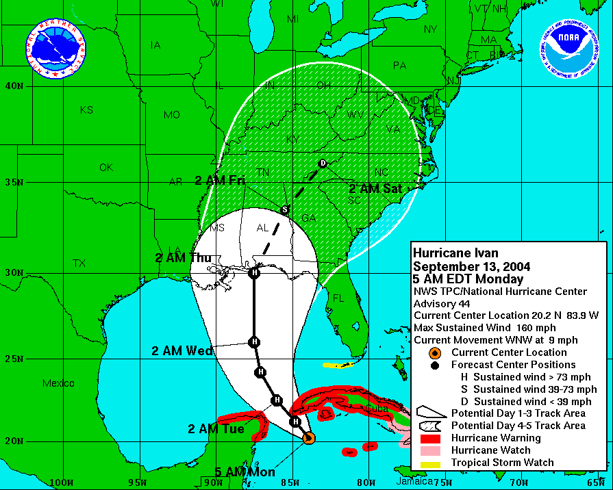
At 2 p.m. Sunday, the Weather Channel reported that the island had been lashed by winds in excess of 200 mph.

Ivan was 60 miles west of Grand Cayman, traveling to the west at 10 mph, according to a National Hurricane Center Advisory.

There are unconfirmed reports that part of the capital, George Town, is “gone”, that roofs are blowing around in the streets of George Town, and that the hospital has been badly damaged, or is possibly also “gone”.

Two British ships are reported to be 250 miles behind Ivan, waiting to come into port to come to Cayman’s aid. The Cayman Islands are a British Overseas Territory (colony).

Vehicles in flood-prone areas have are said to have “just disappeared”.

There is two feet of water at Owen Roberts International Airport.

Hurricane shelters on island are full to capacity.

An estimated 80 percent of the roof of Queensgate House, a waterfront commercial office building on the south side of the capital overlooking the harbour, has been blown off.

“It’s as bad as it can possibly get,” Justin Uzzell, 35, told the Associated Press by telephone about noon Houston time on Sunday, also noon Cayman time (Houston is on Daylight Savings Time, Cayman is not) from his fifth-floor refuge in the Citrus Grove Building downtown. “It’s a horizontal blizzard,” he described, saying he could see no further than the parking lot of the adjacent building. “The air is just foam. It’s a white wall. We’re being buffeted badly”.

At the Marriott Resort on Cayman’s famed Seven Mile Beach, its prime tourism product, windows were blown out of the 300+ room facility, and the cars in the parking lot had water up to their rooftops. Children of guests were said to be “going bonkers” from being “cooped up”.

“A catastrophe”, was how one landlord described the residential area of Crewe Road in George Town.

The island has been without electricity since Saturday evening and phone service is often impossible. Cell phone batteries are wearing down or are spent.

Canal-front developments, such as Governor’s Harbour and Snug Harbour, are flooded.

The Hyatt Britannia Resort’s canal which flows into the North Sound has overflowed due to the storm surge, and the Britannia Villas are flooded inside, as is the golf course. Cars there are under water.

At 12:50 p.m. “winds are fiercer than ever”, reported one Cayman resident on the website stormcarib.com, which featured many posting from people seeking information on their loved ones.

Here in Houston, some 125 evacuees who arrived from Grand Cayman Friday afternoon on a special charter flight hired by Cayman-based Dart Management Ltd. to bring its employee resources to safety, were worried and frustrated at not being able to get through by cell phone, hearing “all circuits are currently busy”. They continue to try to reach friends and relatives in their storm-tossed country.

Although the eye of the storm is now 60 miles southwest of the coast of Grand Cayman, Ivan’s hurricane-force winds (155 mph, with gusts to 190 mph) extend out 90 miles from the storm’s center, and it is presently moving west-northwest at 10 mph. Tropical storm-force winds extend out 120 miles. That means Grand Cayman is in for hours more of continued bashing.

The three Cayman Islands – Cayman Brac, Little Cayman, and Grand Cayman, 90 miles to the southeast of the Sister Islands – are home to about 45,000 people with well over 90 percent of them residing in Grand Cayman.

Flood waters were threatening the integrity of the Allista Towers Building in George Town.

There were unconfirmed reports that the roof had blown off the Kirk Servistar Home Center on Eastern Avenue.

Cars in the area of Cayman’s airport are said to have “floated off down the road”.

There were reports of 135-mile-an-hour winds out of the northeast over the last two hours.

Winds were so strong around noon on Saturday that “trees were bending down to the ground” along the West Bay Road, the island’s main road and tourist strip which runs parallel to Seven Mile Beach.

There is no radio service, leaving residents in the dark as to when and where the storm is going.

At midday people who sought shelter in the Walkers Building in the center of town were said to be okay.

Communiques from the Citrus Grove Building also said people seeking shelter there were safe.

The Huntlaw Building in the same area had its roof torn off around 8 a.m.

If Hurricane Ivan, which is reported to be developing a concentric (second) eye wall, winds increase by just one mile an hour, it will again be classed as a category 5 storm.

It is kicking up waves 15 – 25 feet, or two stories high. Cayman is experiencing 8 – 12-inches of rain.

According to the Weather Channel, Hurricane Ivan is the sixth strongest hurricane in the Atlantic basin in recorded history.

It is taking a track similar to that of Hurricanes Charley and Gilbert, which visited Cayman in 1988, and has been called the “son of Gilbert”.

At noon Cayman time, Ivan’s coordinates were 19 N., 81.5 W., with wind gusts to 190mph.

“The wind is howling and there are no leaves left on any of the trees,” Perry Garrison told his wife, Shruty, in Houston by phone from Cayman.
 
Any report on the people who hid in the caves on Cayman Brac?
 
Okay, it's time to start comparing Ivan to Gilbert. On the below chart, the different colours are different hurricane intensities. Here is the scale:

Tropical depression: green
Tropical storm: yellow
cat 1 hurricane: red
cat 2 hurricane: rose
cat 3 hurricane: purple
cat 4 hurricane: magenta
cat 5 hurricane: white

Why am I posting this? Well, back in 1988, the National Hurricane center kept expecting Gilbert to turn north. Gilbert did not do this until sufficiently weakened over the mountains of Mexico. So when Gilbert was moving WNW, he was following the tropical easterlies. He made a right turn and left the tropical windfield, entering the prevailing westerlies of the temperate zone (30-60 latitude, roughly), on advisory #39 (that's what those little numbers are, advisory numbers).

Gilbert was predicted to turn north as soon as it left Jamaica. But it never did, until after landfall (twice) in Mexico. Why? Gilbert spent 24 hours as a category 5 hurricane before striking near Cancun, and another 18 hours as a cat 4. He lost strength, but regained cat 4 status for 12 hours before striking Mexico a 2nd time. My point is this: Gilbert was so strong, that the prevailing westerlies didn't affect it. Will Ivan do the same? Stay tuned!
 

Attachments

  • gilbert.gif
    gilbert.gif
    14.6 KB · Views: 103
Perfection said:
I wonder if it could cross florida and exit into the atlantic, has that ever happened before?
Plenty of times. In fact, Charley just did it last month. It made one landfall as a cat 4 near Punta Gorda FL, crossed the peninsula, re-entered the Atlantic, and made a 2nd landfall near Myrtle beach SC. Charley never lost hurricane status over Florida, even while inland. He was a hurricane from the time he was near Jamaica, to inland near Wilmington NC.
 
By the way, should Ivan do what the hurricane center believes (and they keep adjusting the track westward, towards New Orleans), then Ivan could look a bit like Camille. I will post Camille's tracking chart here, same rules as above. Note the cat 5 white line! :eek:
 

Attachments

  • camille.gif
    camille.gif
    12.6 KB · Views: 91
Revised tracks. It's pushed further west, and some weather agencies put it as far west as the middle of the Louisiana coastline. The eyewall will not traverse any land before it hits the north american shelf if theese predictions come true. What this will mean for potential of a strengthening to category 5 ocer hot gulf water is not mentioned.

130858W5.gif
 
Did anyone hear about the hurricane in Ireland last month?

Did anyone care?

But when it approaches Florida we're all meant to start whinging and crying.
 
Back
Top Bottom