You are using an out of date browser. It may not display this or other websites correctly.
You should upgrade or use an alternative browser.
You should upgrade or use an alternative browser.
Hurricane Ivan
- Thread starter Quasar1011
- Start date


CivCube
Spicy.
- Joined
- Jan 15, 2003
- Messages
- 5,824
Whoa, calm down. He was just musing in a morbid fashion.PantheraTigris2 said:Yeah, nothin' like some good killin', and homelessness makin'. Right on.
What kind of body count are you hoping for?
Are there any more hurricanes forming after this one?

SeleucusNicator
Diadoch
dgfred said:Ivan has forced the Dolphins/Titans game to Sat instead of Sun
to mention several college games moved also. Must be SERIOUS!
Strangely enough, it might move a Marlins/Expos game to Chicago.
SeleucusNicator said:Strangely enough, it might move a Marlins/Expos game to Chicago.
@SN- It seems they are fighting over ticket sales/income if they play at
Cubs.
SeleucusNicator
Diadoch
dgfred said:@SN- It seems they are fighting over ticket sales/income if they play at
Cubs.
No, that's a different thing altogether. The Marlins/Cubs series to be played in Florida was postponed because of Hurricaine Frances. Those games will be made up at Wrigley and there is where they are having the argument.
If the Marlins/Expos series in Florida is postponned because of Hurricaine Ivan, then those games will be played at US Cellular Field, a "neutral" location.
SeleucusNicator said:No, that's a different thing altogether. The Marlins/Cubs series to be played in Florida was postponed because of Hurricaine Frances. Those games will be made up at Wrigley and there is where they are having the argument.
If the Marlins/Expos series in Florida is postponned because of Hurricaine Ivan, then those games will be played at US Cellular Field, a "neutral" location.
Sorry buddy
 I knew it was the Marlins/Cubs. My bad!

 I've read through the entire thread and am fascinated.
Cuivienen
Deity
- Joined
- Nov 26, 2003
- Messages
- 8,011
Two Category 4 hurricanes have never made landfall in the US in a single year since at least 1900. (Previous records are sketchy.) These are the most intense hurricanes since 1900; a quick scan reveals that there have never been two Category 4 storms in the US in one year. There may not be this year -- Ivan may not be a 4 when it lands.

Provolution
Sage of Quatronia
And on 11. September, I hope the Floridans take Ivan as an omen not to mess up the electoral process once again. ") Very good timing
Very good timing
Very good timingbob rulz
Prince
Luckily Frances went down to a cat 2 before striking.
The devastation on Grenada is bad. Not only were 90% of the homes damaged, the prime minister's residence was destroyed, the entire nutmeg crop (their main economic reliance) was destroyed and the prison was destroyed, releasing 1/3 of the prisoners. Half of them have been caught, but the other half are still on the loose. In the entire Carribean, about 37 people are dead. And it was only cat 3 when it hit Grenada! I can't even imagine the damage when it's done in Jamaica, the Cayman Islands, and Cuba. It is expected to be a cat 3 when it hits Florida, although it is a known fact that they have trouble predicting intensity (just look at Charley).
And now it is hitting Jamaica as a very powerful Cat 4 (barely below cat 5). Damn, Mother Nature is enjoying herself this year isn't she?
And to the person who asked, there are no more hurricanes out there at the moment. There was a tropical depression, but it dissipated within about 12 hours.
Hey Quasar, where did you get those track maps for the historical hurricanes (not Ivan, but the historical ones)? I've been looking for a good website for them, but I haven't found one yet (well, I did, but I lost the link... )
The devastation on Grenada is bad. Not only were 90% of the homes damaged, the prime minister's residence was destroyed, the entire nutmeg crop (their main economic reliance) was destroyed and the prison was destroyed, releasing 1/3 of the prisoners. Half of them have been caught, but the other half are still on the loose. In the entire Carribean, about 37 people are dead. And it was only cat 3 when it hit Grenada! I can't even imagine the damage when it's done in Jamaica, the Cayman Islands, and Cuba. It is expected to be a cat 3 when it hits Florida, although it is a known fact that they have trouble predicting intensity (just look at Charley).
And now it is hitting Jamaica as a very powerful Cat 4 (barely below cat 5). Damn, Mother Nature is enjoying herself this year isn't she?
And to the person who asked, there are no more hurricanes out there at the moment. There was a tropical depression, but it dissipated within about 12 hours.
Hey Quasar, where did you get those track maps for the historical hurricanes (not Ivan, but the historical ones)? I've been looking for a good website for them, but I haven't found one yet (well, I did, but I lost the link...
)bob rulz
Prince
.....
A Hurricane Hunter plane that just flew into the hurricane reported winds of 187 knots...
Just for the record that's 215 mph....easily a Category 5, and one of the strongest hurricanes ever recorded.
EDIT: That's at flight level, not at ground level, btw, it's probably weaker at ground level, but someone with more knowledge on the subject might know better. I'm just waiting for the next advisory, which should be any minute now....
EDIT 2: Okay, they measure winds at ground-level, it's still a strong Category 4. Got me excited for no reason!!! 
A Hurricane Hunter plane that just flew into the hurricane reported winds of 187 knots...
Just for the record that's 215 mph....easily a Category 5, and one of the strongest hurricanes ever recorded.
EDIT: That's at flight level, not at ground level, btw, it's probably weaker at ground level, but someone with more knowledge on the subject might know better. I'm just waiting for the next advisory, which should be any minute now....
EDIT 2: Okay, they measure winds at ground-level, it's still a strong Category 4. Got me excited for no reason!!!
Quasar1011
King of Sylvania
What about 1915? Although these did not hit in the same place, 2 category 4 storms did hit the U.S.Cuivienen said:a quick scan reveals that there have never been two Category 4 storms in the US in one year.
Quasar1011
King of Sylvania
Here is an update on Ivan, provided by Birmingham AL TV station WBMA. I am partial to these guys, because that is where I did my TV internship.
7 AM CDT FAST FACTS ON HURRICANE IVAN:
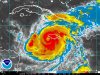
IVAN AN EXTREMELY DANGEROUS CATEGORY 4 HURRICANE
MOVING PAST TIP OF JAMAICA - CAYMANS WILL BE NEXT
COULD BECOME CATEGORY 5 AGAIN TODAY
POSITION: Latitude 17.7 N, Longitude 78.4 W
Just south of the western tip of Jamaica
or 60 miles S of Montego Bay
MOVEMENT: WNW at 8 MPH, additional decrease in forward speed expected)
MAX SUSTAINED WIND: 150 MPH (Strong Category 4)
LOWEST PRESSURE: 923 millibars, 27.26 inches (a substantial drop)
HERE'S THE LATEST INFORMATION ON IVAN AT 7 AM CDT:
The good news is that Ivan maintained a direct westly course during the overnight hours last night. Since the southern coast of Jamaica is oriented in a WNW/ESE fashion, this may have helped to keep the most extreme winds offshore. We can only hope as there has been almost no communication overnight from the island nation.
Ivan's top sustained winds are 150 mph. It peaked in intensity late last evening when winds were 155 mph. Unbelievably, Ivan may strengthen further today as it moves over warm water between Jamaica and Cuba and may become a Category Five hurricane once again. The official forecast calls for maximum sustained winds of 160 mph with gusts to 195 mph.
Ivan is moving WNW at 10 mph and may slow down even further during the next 24 hours. A hurricane warning is in effect for the Cayman Islands, which will be the next port of call for Ivan. Ivan should pass through the Caymans starting late tonight through the predawn hours on Sunday.
Ivan will then cross over Cuba during the predawn hours on Monday. Again, for much of this period between now and Monday, Ivan could be a Category Five hurricane. The disturbing thing is, the center of Ivan is projected to pass over or near the city of Havana!
The NHC track models are in pretty good agreement on the track over Cuba and into the Gulf. The differences become a little more apparent after that.
The official NHC track has been shifting to the left ever so slightly with each new forecast package. It is now pretty much in consensus with the models after 48 hours. The official track carries it further to the west of Key West and Tampa, which could be good news for those areas, but bad news for the Florida Big Bend area. We caution that forecast errors that far out can be as much as 250 miles or more. Literally the entire state of Florida, most of Georgia and some of South Carolina is in the "cone of error" between now and landfall.
EARLY MORNING MODEL NOTES
*The 06z run of the GFS is a little west of the previous runs in the early periods. By Monday afternoon, the storm is just crossing the western tip of Cuba. By Tuesday afternoon, the intense storm dominates the southeastern Gulf of Mexico. On Wednesday afternoon, the hurricane is making its approach to the Florida Coast in the Big Bend area. It goes inland near St. Marks late Wednesday afternoon and pushes into southern Georgia. By Thursday morning, it is moving slowly through Georgia, south of Atlanta. Rain edges into eastern sections of our state.
*The 06z run of the ETA carries Ivan almost due west into the western Caribbean over the next 48 hours to a point well south of Cuba early on Monday. By Tuesday afternoon, it takes the storm into the South Central Gulf, which would be a more ominous situation for the Northwest Florida and perhaps Alabama coasts, but we are discounting the solution at this time. The ETA has not perfromed well with tropical system this year.
Here is a quick look at some of the other important track models:
*The 18z AVN carries Ivan over SW Florida in the Florida Bay area, across the Peninsula, exits near Daytona Beach and makes a second landfall in the Wilmington, NC area. This is one of the most eastern model solutions.
*The entire 00z GFDL is not in. The 18z run carried the hurricane to near Panama City or Apalachicola. The 00z run looked a little west of that. This is a western solution.
*The 00z run of the UKMET takes the storm to near Apalachicola, then turns it northeast through Georgia and the Carolinas.
*Here is the latest spread of the hurricane model tracks with the NHC track superimposed.
MORE IVAN NOTES
*The entire power grid in Jamaica was taken down about 6 pm. There is no power anywhere on the island.
*Here is a disturbing report relayed by amateur radio...it seems to be credible...
Relayed Report from my Western Mass. SKYWARN Coordinator from a person on Internet Chat in Jamaica. (We believe that to be correct because we trace routed his IP address to Jamaica.)Person did not want to be identified. The person stated that in Mandeville, Jamaica, some structural damage was beginning to occur to homes with winds estimated at 130 KM/Hr or 80 MPH at 2300 EDT. The person stated that the winds were much stronger than Gilbert in 1998. Also at 11 PM, the same person reported hearing from Kingston Jamaica that homes were beginning to get major damage and some were being washed away by storm surge. They also stated that phone communication to Kingston and other major cities were out.
*Most Miami gas stations are out or gas or running low. There are false rumors about rationing.
*THE STORY OF KEY WEST: It is the southernmost city in the USA and it is largly empty due to today's mandantory evacuation order. The Florida Keys is a 100 mile chain of islands that hardly have any elevation and storm surge is a real threat. The highest elevation in the city of Key West is only about 15 feet. Ivan is forecast to pass west of Key West Monday, however, as always, it is possible that Ivan could come closer.
*The mandatory evacuation of the Florida Keys apparently went smoothly Friday. The Lower Keys went under mandatory evacuation order starting at 7 a.m., the Middle Keys at noon and the Upper Keys at 4 p.m. EDT. Visitors and Non-residents were ordered to evacuate on Thursday, along with all mobile homes and recreational vehicles.
7 AM CDT FAST FACTS ON HURRICANE IVAN:
IVAN AN EXTREMELY DANGEROUS CATEGORY 4 HURRICANE
MOVING PAST TIP OF JAMAICA - CAYMANS WILL BE NEXT
COULD BECOME CATEGORY 5 AGAIN TODAY
POSITION: Latitude 17.7 N, Longitude 78.4 W
Just south of the western tip of Jamaica
or 60 miles S of Montego Bay
MOVEMENT: WNW at 8 MPH, additional decrease in forward speed expected)
MAX SUSTAINED WIND: 150 MPH (Strong Category 4)
LOWEST PRESSURE: 923 millibars, 27.26 inches (a substantial drop)
HERE'S THE LATEST INFORMATION ON IVAN AT 7 AM CDT:
The good news is that Ivan maintained a direct westly course during the overnight hours last night. Since the southern coast of Jamaica is oriented in a WNW/ESE fashion, this may have helped to keep the most extreme winds offshore. We can only hope as there has been almost no communication overnight from the island nation.
Ivan's top sustained winds are 150 mph. It peaked in intensity late last evening when winds were 155 mph. Unbelievably, Ivan may strengthen further today as it moves over warm water between Jamaica and Cuba and may become a Category Five hurricane once again. The official forecast calls for maximum sustained winds of 160 mph with gusts to 195 mph.
Ivan is moving WNW at 10 mph and may slow down even further during the next 24 hours. A hurricane warning is in effect for the Cayman Islands, which will be the next port of call for Ivan. Ivan should pass through the Caymans starting late tonight through the predawn hours on Sunday.
Ivan will then cross over Cuba during the predawn hours on Monday. Again, for much of this period between now and Monday, Ivan could be a Category Five hurricane. The disturbing thing is, the center of Ivan is projected to pass over or near the city of Havana!
The NHC track models are in pretty good agreement on the track over Cuba and into the Gulf. The differences become a little more apparent after that.
The official NHC track has been shifting to the left ever so slightly with each new forecast package. It is now pretty much in consensus with the models after 48 hours. The official track carries it further to the west of Key West and Tampa, which could be good news for those areas, but bad news for the Florida Big Bend area. We caution that forecast errors that far out can be as much as 250 miles or more. Literally the entire state of Florida, most of Georgia and some of South Carolina is in the "cone of error" between now and landfall.
EARLY MORNING MODEL NOTES
*The 06z run of the GFS is a little west of the previous runs in the early periods. By Monday afternoon, the storm is just crossing the western tip of Cuba. By Tuesday afternoon, the intense storm dominates the southeastern Gulf of Mexico. On Wednesday afternoon, the hurricane is making its approach to the Florida Coast in the Big Bend area. It goes inland near St. Marks late Wednesday afternoon and pushes into southern Georgia. By Thursday morning, it is moving slowly through Georgia, south of Atlanta. Rain edges into eastern sections of our state.
*The 06z run of the ETA carries Ivan almost due west into the western Caribbean over the next 48 hours to a point well south of Cuba early on Monday. By Tuesday afternoon, it takes the storm into the South Central Gulf, which would be a more ominous situation for the Northwest Florida and perhaps Alabama coasts, but we are discounting the solution at this time. The ETA has not perfromed well with tropical system this year.
Here is a quick look at some of the other important track models:
*The 18z AVN carries Ivan over SW Florida in the Florida Bay area, across the Peninsula, exits near Daytona Beach and makes a second landfall in the Wilmington, NC area. This is one of the most eastern model solutions.
*The entire 00z GFDL is not in. The 18z run carried the hurricane to near Panama City or Apalachicola. The 00z run looked a little west of that. This is a western solution.
*The 00z run of the UKMET takes the storm to near Apalachicola, then turns it northeast through Georgia and the Carolinas.
*Here is the latest spread of the hurricane model tracks with the NHC track superimposed.
MORE IVAN NOTES
*The entire power grid in Jamaica was taken down about 6 pm. There is no power anywhere on the island.
*Here is a disturbing report relayed by amateur radio...it seems to be credible...
Relayed Report from my Western Mass. SKYWARN Coordinator from a person on Internet Chat in Jamaica. (We believe that to be correct because we trace routed his IP address to Jamaica.)Person did not want to be identified. The person stated that in Mandeville, Jamaica, some structural damage was beginning to occur to homes with winds estimated at 130 KM/Hr or 80 MPH at 2300 EDT. The person stated that the winds were much stronger than Gilbert in 1998. Also at 11 PM, the same person reported hearing from Kingston Jamaica that homes were beginning to get major damage and some were being washed away by storm surge. They also stated that phone communication to Kingston and other major cities were out.
*Most Miami gas stations are out or gas or running low. There are false rumors about rationing.
*THE STORY OF KEY WEST: It is the southernmost city in the USA and it is largly empty due to today's mandantory evacuation order. The Florida Keys is a 100 mile chain of islands that hardly have any elevation and storm surge is a real threat. The highest elevation in the city of Key West is only about 15 feet. Ivan is forecast to pass west of Key West Monday, however, as always, it is possible that Ivan could come closer.
*The mandatory evacuation of the Florida Keys apparently went smoothly Friday. The Lower Keys went under mandatory evacuation order starting at 7 a.m., the Middle Keys at noon and the Upper Keys at 4 p.m. EDT. Visitors and Non-residents were ordered to evacuate on Thursday, along with all mobile homes and recreational vehicles.
Attachments
The path now looks like it's gonna hit the Florida panhandle, but affect cities in the North East later in the week. Origanally, it was to head due north like Hurricane Frances. We only got a few spurts of downpours here when it came by.
Similar threads
- Replies
- 80
- Views
- 3K