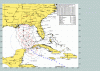
Hurricane Ivan

It may become a Hurricane north of the Bahamas, if only a Category One. The water between Florida and the Bahamas is warmer than the majority of the Caribbean.
 
I just came across the U.S. Navy's version of the official forecast tracking chart. It shows more detailed data than the NHC charts. For one, it gives the distance from point of expected landfall, to some places along the coast. That is in one of the tables to the right. Notice it says: "Pensacola-3".

Also, it shows the radius of hurricane-force winds in red, and tropical storm force winds in black. These are shown for 06Z and 18Z each day (1 a.m. and 1 p.m. in the central time zone). Notice that for each frame, the right half of the storm has hurricane-force winds that extend further than the left side. Also, the right-front quadrant has winds that extend further than the right-rear quadrant. As I have mentioned before, this is keeping with the basic hurricane principle that the worst weather in a hurricane is in the right-front quadrant with respect to motion.

According to this chart, if the forecast is correct, I can expect 80-100 mph sustained winds here in Mobile. There would be higher gusts also. Hurricane-force winds would begin here Wednesday evening, or possibly late afternoon.

For any of you to my east, along the Florida panhandle, I'm sure you're already taking precautions too!

By the way, after the storm hits, my house may be without power for awhile, but my office has a generator. I'll try to post what I can, when I can. May even post some pics from my digital camera, weather permitting. ;)

Here is the navy chart:
 

Attachments

  • Ivan9.gif
    Ivan9.gif
    53.3 KB · Views: 126
Ivan retained intensity as it clipped Cuba, but some shear is expected to weaken it through the Gulf of Mexico.

Meanwhile, according to the latest advisory, the tropical depression remains at the same strength, and the track has shifted a little to the north.
 
MSTK said:
Let's hope it reaches cat 5 status again ;)

And we would wish that for what reason? :rolleyes:
 
eyrei said:
And we would wish that for what reason? :rolleyes:
Some people are just bored. Chaos gives them something exciting to talk about.
 
I have an ugly feeling in the pit of my stomach... Since Ivan continues to drift persistently west of the predicted path, it seems like New Orleans may end up in the crosshairs of a hurricane recharged by the Gulf into a Cat 5.

While I certainly don't want Quasar to take a direct hit (as intellectually thrilling as that would be for him ;) ) I would much rather the Florida panhandle or the Alabama/Mississippi coasts take the hit rather than a major city that (IIRC) is below sea level in the first place.

Disclaimer: I am not a meteorologist.
 
Perfection said:
Well hopefully after Ivan and Jeanne the only K to enter Florida will be Kerry sweeping it like a Hurricane!

Sorry, had to make the joke.

:shakehead He will sweep in like a hurricane b/c he blows ALOT of hot air!
Sorry, not a joke :mischief: .

It does seem that New Orleans may be in the crosshairs :eek: :sad: .
 
Doesn't New Orleans have some kind of levy that could break and flood the whole city? Isn't a really strong hurricane one of the things in a doomsday scenario that could break that levy?
 
I don't know, but I've heard that much of, if not all of, New Orleans is actually below sea level...huge flooding potential there, obviously....so good luck to those people down there.
 
The Yankee said:
I don't know, but I've heard that much of, if not all of, New Orleans is actually below sea level...huge flooding potential there, obviously....so good luck to those people down there.

I saw on TV that they would try to evacuate :eek: :dubious: , which would
be a disaster in itself. Too many people, not enough roads or time :( .
What a nightmare!
 
Would try to evacuate? I think it's a little late to start trying it now...that should have happened a few days ago if there were going to be that many problems. The Keys have been deserted for a couple days already.
 
The Yankee said:
Would try to evacuate? I think it's a little late to start trying it now...that should have happened a few days ago if there were going to be that many problems. The Keys have been deserted for a couple days already.


Yeah, the mayor was on tv asking those who could to leave and others to
consider it :eek: . Today is supposed to be nice there but thing will be
deteriorating quickly :scan: .
 
Current projections have it going through Dallas County (AL) at 2 am on Thursday morning...which is unfortunately where I happen to reside. :(
 
SeleucusNicator said:
Doesn't New Orleans have some kind of levy that could break and flood the whole city? Isn't a really strong hurricane one of the things in a doomsday scenario that could break that levy?
Judging by the context, I presume that levy means dam, but I never heard that before. For all I know, they seize the citizens' homes and stick all their property in the harbour to push the coast line out.. :crazyeye:

Please confirm the meaning of levy.
 
Well I just talked to my mom in Pensacola and they seem pretty confident that they'll ride this storm out pretty comfortably. She's and old pro at this and has been through worse. I'll give her a call sometime later on Friday. Hopefully I'll get through.
 
stormbind said:
Judging by the context, I presume that levy means dam, but I never heard that before. For all I know, they seize the citizens' homes and stick all their property in the harbour to push the coast line out.. :crazyeye:

Please confirm the meaning of levy.


This levy talk is making me think of Led Zepplin! ;)

'when the levy breaks I'll have no place to stay'

and Pink Floyd: 'if the damn breaks many years too soon; and there is no
room upon the hill'

:cool: :D :cooool: Great tunes.
 
Flak said:
Well I just talked to my mom in Pensacola and they seem pretty confident that they'll ride this storm out pretty comfortably. She's and old pro at this and has been through worse. I'll give her a call sometime later on Friday. Hopefully I'll get through.


Pensacola has the luck of having both a barrier island (Fort Pickens located on it) and being on higher ground. Driving down (South) Pace Blvd. and you can get a feel of how much higher. If I lived on Santa Rosa Island (the barrier island) though, I would be running.
 
Back
Top Bottom