You are using an out of date browser. It may not display this or other websites correctly.
You should upgrade or use an alternative browser.
You should upgrade or use an alternative browser.
NES World/Regional Maps Requests Thread
- Thread starter Chieftess
- Start date
Kentharu
Zebra Commander
ok im gonna start my nes soon (in about a month after the other new NES get established) but i have no idea how to work the map, tips anyone? what program to use? normal paint or adobe (i think i have that)
North King
blech
- Joined
- Jan 2, 2004
- Messages
- 18,165
Paint works ok for me. I started out imitating Kamilian, but have developed my own style.
Goober
Turning Right ...
Hi guys,
I was wondering if anybody has a map with the US States on it lying around. I just need the lines for the states, no colour, I can handle that. If you have it on a world map, that would be awesome, preferably modern-day.
I have a bueatiful world map made by ... hrm, erez maybe? Panda? I'm not sure. It has everything I need, I just need the locations of the US States.
Thanks a lot,
Goober.
(For those that know what this is about, DO NOT SAY ANYTHING! Secrets are meant to be kept! For the rest of you, this will make more sense in about 2 months.)
North King
blech
- Joined
- Jan 2, 2004
- Messages
- 18,165
Well, there are many maps like that. I don't believe we have seen one which has them well done on a world map, however. I'll look into it.
Dreadnought
Deity
Wait, is it a mpa of just US States, or the world? THe first I've seen some, the latter you'd need to make.
Goober
Turning Right ...
Well, I need a world map with the US States on it. I have the world map, just not the states, and I need to draw a line separating the USA in a certain fashion for my upcoming NES. If you have a map with just the US States on it (preferably just lines, not coloured), then I can cut and paste that into the world map.
To answer the question, with just the US States. And where have you seen them? I searched this entire thread, and nothing. Would it be in a future version of this thread?
EDIT: Using this Map: http://forums.civfanatics.com/attachment.php?attachmentid=60826
Thank you Plexus!
To answer the question, with just the US States. And where have you seen them? I searched this entire thread, and nothing. Would it be in a future version of this thread?
EDIT: Using this Map: http://forums.civfanatics.com/attachment.php?attachmentid=60826
Thank you Plexus!
Goober
Turning Right ...
Ok, I have come to a realization that NESers like Cities and Rivers on their Maps. I have looked through the threads, and I have found very nice maps with cities, and very nice maps with Rivers, but none with both. Just to make things unecessarily complicated, I will need to colour it and will need Modern-day borders on it (which I shall then process to significantly alter).
So, I need to find such a map. Icarus kindly pointed me out this map

I raelly love this map, so if somebody who has skills with pictures could put Rivers on it, I would greatly appreciate that.
I would prefer if the Rivers looking something like this map:

I'm going to keep looking through threads, but I have yet to find what I am looking for. Oh, I also need modern-day borders on it.
Thanks a lot!
And if I get this map, then I don't need the map with the US States (unless somebody has the time, or has a good map with the US States on it.)
Kentharu
Zebra Commander
does anyone have a map of the russia states/provinces (or whatever they are called)
erez87
Lord of Random
- Joined
- May 16, 2002
- Messages
- 13,500
http://forums.civfanatics.com/attachment.php?attachmentid=109547&d=1135981246
there your cities Goober.
there your cities Goober.
Jason The King
Deity
I don't think its his map.
North King
blech
- Joined
- Jan 2, 2004
- Messages
- 18,165
There are some things wrong with the city map, but it is roughly accurate. If a native of a land who feels wrongly depicted wants to go in there and correct it, be my guest.

Gelion
Retired Captain
Graphical Q Help needed here:
http://forums.civfanatics.com/showthread.php?p=3829450#post3829450
http://forums.civfanatics.com/showthread.php?p=3829450#post3829450
Silver Steak
The Ghost of SS
Any place where I can find great randomized maps? Maybe someone could post one or two nice ones... ")
Erik Mesoy
Core Tester / Intern
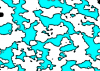
Silver, the GIMP can do almost anything. I'm plugging it everywhere, might as well do so here too.
Filters -> Render -> Clouds -> Solid Noise
followed by
Tools -> Color Tools -> Threshhold
You'll get white/black areas. Use color fill to turn the black areas blue. Then go to Filters -> Artistic -> Cartoon to create borders.
I made the attached image in all of two minutes.
Filters -> Render -> Clouds -> Solid Noise
followed by
Tools -> Color Tools -> Threshhold
You'll get white/black areas. Use color fill to turn the black areas blue. Then go to Filters -> Artistic -> Cartoon to create borders.
I made the attached image in all of two minutes.
Attachments
Similar threads
- Replies
- 3
- Views
- 556
- Replies
- 6
- Views
- 1K