Altered Maps 4: Partitioning Eastern Europe Like In The Good Old Days

Status
Not open for further replies.

You know, looking at this map again it is striking how well you can see former political divisions.

The Iron Curtain can still clearly be seen - although large parts of central and Baltic Europe are catching up fast to their western and northern neighbours.

You can also still see Yugoslavia, as well as the Soviet Union.

What's up with Portugal?
 
I just got really bored one day and decided to fool around.

Spoiler :


Does anyone know of a way I could blow up the image?
 
What's up with Portugal?

Were lazy, and like it that way.
Or, we are idiots who keep electing awful governments since 1985.
Take your pick.

And Spain should the the same color too. They'll soon be - building apartments everywhere doesn't create lasting wealth. Not too different from the "irish miracle" also.
 
Were lazy, and like it that way.
Or, we are idiots who keep electing awful governments since 1985.
Take your pick.

And Spain should the the same color too. They'll soon be - building apartments everywhere doesn't create lasting wealth. Not too different from the "irish miracle" also.

Awful governments? Maybe, but how can we know it is going to be a bad government beforehand? It's a game of (un)luck...
 
I just got really bored one day and decided to fool around.

Spoiler :


Does anyone know of a way I could blow up the image?
Uh, what the hell is that map supposed to be?

Spoiler :

The world according to me. Made it taking this quiz and just erasing those which I didn't get. I missed almost all the Pacific Islands except for Palau and Micronesia and all the West Indies except for Dominica, which I only got because I tried to type Dominican Republic. Some of these (Somalia, Bulgaria, Kenya, Netherlands) are just inexcusable, I admit. (I missed San Marino also.)
 
Sorry for double post. See above post for the map preciously in this post.
 
Uh, what the hell is that map supposed to be?

Spoiler :

The world according to me. Made it taking this quiz and just erasing those which I didn't get. I missed almost all the Pacific Islands except for Palau and Micronesia and all the West Indies except for Dominica, which I only got because I tried to type Dominican Republic. Some of these (Somalia, Bulgaria, Kenya, Netherlands) are just inexcusable, I admit. (I missed San Marino also.)

This is awesome. I'll have to make one, if only I could remember what I missed... :p
 
Partly inspired by this thread


After the Great Chinese Space Bats War, the three main Pacific Alliance powers divided up China into occupation zones. The Koreans run Manchuria, the Japanese administered the North China Plains, and the Americans occupied the south. The Indians were left out of occupying China proper, but was allowed to annex some border territories and given a free hand in governing Burma. The Mongolians, Uighurs and Tibetans declared their independence and ethnically-cleansed their new countries of Han Chinese. What's left of China is governed by a self-proclaimed "Caliphate of China".
 
I must say, I approve of the GCSB War! :D This guarantees the future superpowers are both liberal democracies(USA and EU).

The division of the map itself also looks rather awesome, to say the least. I like the red blotch in the South! ...China actually looks pretty cool when partitioned.

...Makes me wonder if Japan and Korea will try to throw off the shackles of American suzerainty in the near future. :mischief: 
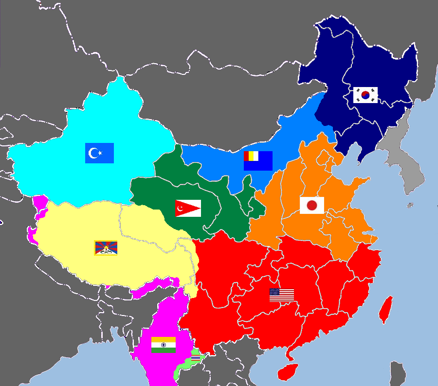
The Second Great Asian Space Bats War!
 
Status
Not open for further replies.
Top Bottom