Can you identify what these world maps represent?

Okay, I will make a little switch on map Gamma.

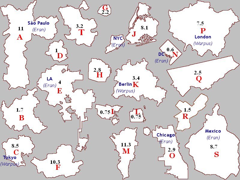
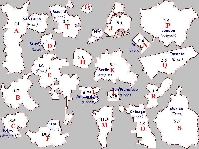
As Eran Arcadia said, it pictures several world cities boundaries with their population being expressed in millions of inhabitants. The detail I've mentionned on my earlier post was simply that they are all pictured at the same scale.

Now the game will become tougher. Could you guess which are the world cities in question? :D

Here's the map with a letter for each city:

secretmap3bis.jpg


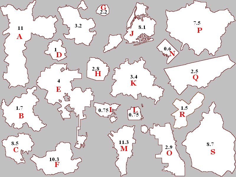
Eran Arcadia already guessed 4 of these:
- E: Los Angeles
- J: New York City
- N: Washington, DC
- O: Chicago
 
You're both correct!

- Eran of Arcadia: 5 points.
- Warpus: 3 points
:D

secretmap3-1.jpg


EDIT: Sorry Warpus, I didn't notice you edited your post, but you're correct. C is Tokyo.
 
D- Houston? Just a crazy guess. :p
hehe. It could have been but unfortunately no it's not. :)
After having checked on Wikipedia, in land area, Houston is 4 times larger than city D.

Eran of Arcadia said:
A is Sao Paolo.
Correct!

- Eran of Arcadia: 6 points
- Warpus: 3 points

secretmap3-2.jpg
 
I can't figure out what M is, to save my life. There's only so many options it could be, with that high level of population. The only one I can find that it quasi-resembles is Mumbai, but Mumbai doesn't really look like that, plus it has over 2 million more people. :hmm:


Blast! :mad:


j/k On a side note, what's with the Greek designations? Is this map college? Frat houses, etc.?
 
Is alpha related to nuclear reactors?
No no, it's nothing neither related to sports, nor related to anything "institutional".
It's much more materialistic than that.

:confused:

I've been to Sao Paulo five times, and I'd never say it was that shape!

http://maps.google.co.uk/maps?f=q&h...658,-46.61499&spn=0.300874,0.466919&z=11&om=1
The cities outlines pictured on the map aren't about the urban sprawl. It's exclusively about administrative boundaries. What is pictured on the map is the outlines of the Município de São Paulo.

Now some urban sprawl exceeds well beyond the administrative boundaries for some cities such as NYC or Tokyo... while some others are actually larger than their urban sprawl as it's the case of Berlin. :)
 
Alpha

Number of 3 star restaurants?
Number of supercomputers?
Thousands of km of railways?
Number of plants producing biomethane?
Number of marine protected areas?
Number of principal ports?
Number of days of reserves of oil?
Number of "regions"?
Number of IKEA stores?
 
Alpha

[...]
Number of IKEA stores?
:eek:
You got it !!!!! How did you do that!!!! :dubious:

Anyway, good job! You've stunned me! :goodjob:

Frankly, I was sure I'd have to give multiple hints in order to put people on the right tracks... I never imagined someone could find it just like that. Could you tell me what made you think of this? :)


EDIT: Here's the original map.

ikea.jpg
 
Woohooo!!! Do I get a prize? ;)

I'm not revealing my secret either :D

edit: Okay, I will tell you how I did it

I googled "Germany has 43" "France has 23" etc. and looked at what came up.. most of it was garbage, it took a while until I get to the hit on IKEA.

I know that the "principal ports" answer is kinda silly, considering there are landlocked countries involved, but I thought it might nevertheless be related somehow.
 
Back
Top Bottom