Climate Change Anecdotes

Climate activists fill golf holes with cement after water ban exemption​

Climate activists in south-eastern France have filled golf course holes with cement to protest against the exemption of golf greens from water bans amid the country's severe drought.
The group targeted sites near the city of Toulouse, calling golf the "leisure industry of the most privileged".
The exemption of golf greens has sparked controversy as 100 French villages are short of drinking water.
Golf officials say greens would die in three days without water.
"A golf course without a green is like an ice-rink without ice," Gérard Rougier of the French Golf Federation told the France Info news website. He added that 15,000 people worked in golf courses across France.
The recent action targeted courses in the towns Vieille-Toulouse and Blagnac. It was claimed by the local branch of the Extinction Rebellion movement.

In a petition, they said the exemption shows that "economic madness takes precedence over ecological reason".
While residents cannot water their gardens or wash their cars in the worst-hit municipalities, golf courses have escaped the nationwide restrictions, it said.

The water bans are decreed nationally, but enforcement is at the discretion of local officials. So far, only one region, Ille-et-Villaine in western France, has diverged, banning the watering of golf courses.
The mayor of the south-eastern city of Grenoble city, a member of the Green party, criticised the exemption saying: "We continue to protect the rich and powerful."
Some constraints on the golf course remain: watering must be carried out at night and no more than 30% of the usual volume of watering should be used.
Some parts of the Loire river have virtually dried up completely. Across two-thirds of France, a state of crisis has been declared by the government, with rainfall down by some 85%.
https://www.bbc.com/news/world-europe-62532840
 
We are kind of in a perfect storm of food crisis right now, and the Ukrainian invasion. Many of the people reading this post will only experience it as a price increase, nothing too serious compared to what other people are going to experience
 
NPR, 12 August 2022 - "A cataclysmic flood is coming for California. Climate change makes it more likely."
NPR said:
When the big flood comes, it will threaten millions of people, the world's fifth-largest economy and an area that produces a quarter of the nation's food. Parts of California's capital will be underwater. The state's crop-crossed Central Valley will be an inland sea.

The scenario, dubbed the "ARkStorm scenario" by researchers from the U.S. Geological Survey's Multi Hazards Demonstration Project, is an eventuality. It will happen, according to new research.

The study, published in Science Advances, is part of a larger scientific effort to prepare policymakers and California for the state's "other Big One" — a cataclysmic flood event that experts say could cause more than a million people to flee their homes and nearly $1 trillion worth of damage. And human-caused climate change is greatly increasing the odds, the research finds.

"Climate change has probably already doubled the risk of an extremely severe storm sequence in California, like the one in the study," says Daniel Swain, a climate scientist at the University of California Los Angeles and a co-author of the study. "But each additional degree of warming is going to further increase that risk further."

U.S. Dept of the Interior, U.S. Geological Survey, Multihazards Demonstration Project - "Overview of the Arkstorm Scenario"
USGS said:
[In the ARkStorm scenario] the Central Valley experiences hypothetical flooding 300 miles long and 20 or more miles wide. Serious flooding also occurs in Orange County, Los Angeles County, San Diego, the San Francisco Bay area, and other coastal communities. Windspeeds in some places reach 125 miles per hour, hurricane-force winds. Across wider areas of the state, winds reach 60 miles per hour. Hundreds of landslides damage roads, highways, and homes. Property damage exceeds $300 billion, most from flooding. Demand surge (an increase in labor rates and other repair costs after major natural disasters) could increase property losses by 20 percent. Agricultural losses and other costs to repair lifelines, dewater (drain) flooded islands, and repair damage from landslides, brings the total direct property loss to nearly $400 billion, of which $20 to $30 billion would be recoverable through public and commercial insurance. Power, water, sewer, and other lifelines experience damage that takes weeks or months to restore. Flooding evacuation could involve 1.5 million residents in the inland region and delta counties. Business interruption costs reach $325 billion in addition to the $400 billion property repair costs, meaning that an ARkStorm could cost on the order of $725 billion, which is nearly 3 times the loss deemed to be realistic by the ShakeOut authors for a severe southern California earthquake, an event with roughly the same annual occurrence probability.

Areas flooded by the Winter storm of 1861-1862:
Spoiler :

Downtown Sacramento, January, 1862:
Spoiler :
 
NPR, 12 August 2022 - "A cataclysmic flood is coming for California. Climate change makes it more likely."


U.S. Dept of the Interior, U.S. Geological Survey, Multihazards Demonstration Project - "Overview of the Arkstorm Scenario"


Areas flooded by the Winter storm of 1861-1862:
Spoiler :

Downtown Sacramento, January, 1862:
Spoiler :
Wow, the 1862 flood today would do $1 trillion in damage. :eek:

Sacramento, northern San Francisco, east L.A., and northeast San Diego.


California also due for a giant earthquake.

Hopefully the giant flood does not cause the giant earthquake. :hmm:
 
Wow, the 1862 flood today would do $1 trillion in damage. :eek:

Sacramento, northern San Francisco, east L.A., and northeast San Diego.


California also due for a giant earthquake.

Hopefully the giant flood does not cause the giant earthquake. :hmm:
Population of California in the 1860 U.S. census: 379,994.
Population of California today: A wee bit more than that.

I read somewhere, might've been that NPR report, that California supplies 25% of the country's food.
 
Www+
Wow, the 1862 flood today would do $1 trillion in damage. :eek:

Sacramento, northern San Francisco, east L.A., and northeast San Diego.


California also due for a giant earthquake.

Hopefully the giant flood does not cause the giant earthquake. :hmm:

It's actually possible for the weight of floodwaters to act as a trigger for earthquakes IIRC
 

Climate activists fill golf holes with cement after water ban exemption​

Climate activists in south-eastern France have filled golf course holes with cement to protest against the exemption of golf greens from water bans amid the country's severe drought.
The group targeted sites near the city of Toulouse, calling golf the "leisure industry of the most privileged".
The exemption of golf greens has sparked controversy as 100 French villages are short of drinking water.
Golf officials say greens would die in three days without water.
"A golf course without a green is like an ice-rink without ice," Gérard Rougier of the French Golf Federation told the France Info news website. He added that 15,000 people worked in golf courses across France.
The recent action targeted courses in the towns Vieille-Toulouse and Blagnac. It was claimed by the local branch of the Extinction Rebellion movement.

In a petition, they said the exemption shows that "economic madness takes precedence over ecological reason".
While residents cannot water their gardens or wash their cars in the worst-hit municipalities, golf courses have escaped the nationwide restrictions, it said.

The water bans are decreed nationally, but enforcement is at the discretion of local officials. So far, only one region, Ille-et-Villaine in western France, has diverged, banning the watering of golf courses.
The mayor of the south-eastern city of Grenoble city, a member of the Green party, criticised the exemption saying: "We continue to protect the rich and powerful."
Some constraints on the golf course remain: watering must be carried out at night and no more than 30% of the usual volume of watering should be used.
Some parts of the Loire river have virtually dried up completely. Across two-thirds of France, a state of crisis has been declared by the government, with rainfall down by some 85%.
https://www.bbc.com/news/world-europe-62532840

Damn July here we had the opposite 3-4 months rain in a month. Then a cold snap.

Nice day today hit 10C at 9amish. Currently 14.

Barely broke double figures last couple of months.
 
It is said we're having an unprecedentedly cold winter in Australia, but if you go back and look at historical weather records, it's actually an average or slightly-warmer-than-average winter. It's just that it's been more-than-slightly-warmer-than-average for so many winters lately that having a normal winter feels unusually cold.
 
It is said we're having an unprecedentedly cold winter in Australia, but if you go back and look at historical weather records, it's actually an average or slightly-warmer-than-average winter. It's just that it's been more-than-slightly-warmer-than-average for so many winters lately that having a normal winter feels unusually cold.
Much wetter than usual here in Canberra. It moderates the temps. Less really cold nights and very few clear warm days, so the *days* are colder but the average seasonal figure ends up not much different.

Looking at US and Euro now getting dry and burnt really is nothing new to us. Yeah, we know, we had that already. Did they think they were immune?
 
It is said we're having an unprecedentedly cold winter in Australia, but if you go back and look at historical weather records, it's actually an average or slightly-warmer-than-average winter. It's just that it's been more-than-slightly-warmer-than-average for so many winters lately that having a normal winter feels unusually cold.

Similar here across the ditch it's cold but there's been no snow or freeze at 4:30pm.

Just cold compared to last few years.
 
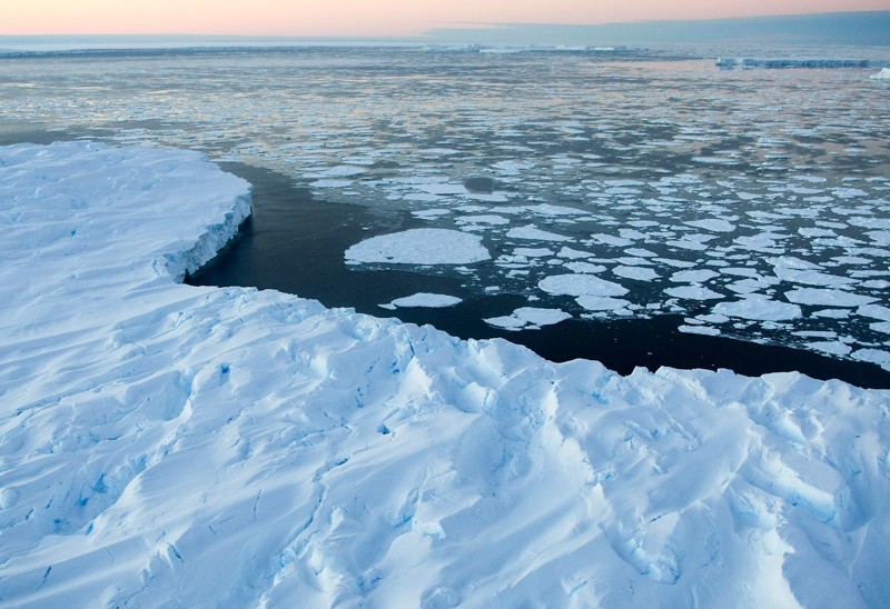
World’s largest ice sheet threatened by warm water surge

Westerly winds are thrusting warm waters towards the East Antarctic ice sheet, and have thinned the region’s ice masses at alarming rates over recent decades, a study has found.​
Ice shelves float on the ocean, extending from and buttressing continental glaciers that amass to form ice sheets. Unlike ice masses in West Antarctica, which are melting at a staggering rate, the East Antarctic ice sheet was thought to be sheltered from ocean warming by cold, dense seawater that forms on the continental shelf, near ice shelves.​
But over the past ten years, data and observations have shown that the East Antarctic ice sheet, too, is under increasing threat from warm salty water, which is melting ice shelves from beneath. Yet past studies have struggled to measure the extent of the warming and pinpoint the processes driving it.​
Oceanographers Laura Herraiz-Borreguero at Australia’s national science agency, CSIRO, and Alberto Naveira Garabato at the University of Southampton, UK, sought to understand what is happening by collating and analysing publicly available records of ocean temperature and salinity, going back 90 years, along the East Antarctic continental slope and open ocean. They compared these oceanographic observations to satellite data used to map the boundaries of ocean currents.​
The pair found that ocean temperatures in East Antarctica have risen by up to 2 ℃ since the early twentieth century, and the trend is accelerating. The rate of ocean warming in the region has tripled since the 1990s, they found, with the strongest warming occurring over the East Antarctic continental slope — near the glaciers whose protruding ice shelves have thinned or retreated most rapidly. Among these are the Denman, Vanderford and Totten glaciers. “It was really striking that the largest warming was in these areas where we know the ice sheet is losing ice mass,” says Herraiz-Borreguero.​

The consequences of warmer waters lapping the continental shelf would be severe. If warm water is able to penetrate the continental shelf and heat glacial ice, which currently sits on bedrock below sea level, “then the ice melt would be almost unstoppable”, says Herraiz-Borreguero.​
Writeup Paper (paywalled)

 
Boreal forest on the move

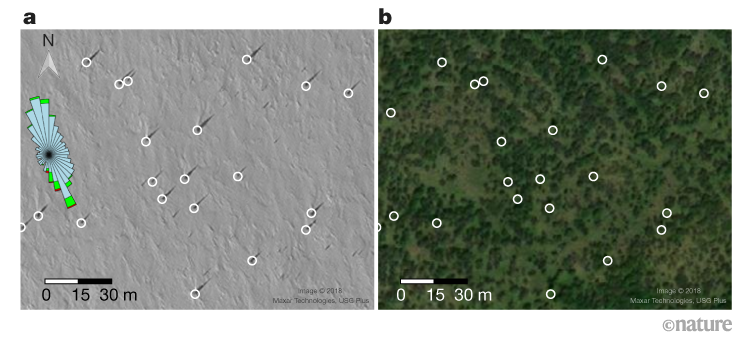
A newly discovered population of white-spruce trees is advancing northwards in Arctic Alaska, driven by ecological factors that are associated with climate change at this latitude — including stronger winter winds, deeper snow and greater nutrient availability in the soil.​
A boreal biome shift would change the availability of subsistence resources, such as reindeer (Rangifer tarandus; also known as caribou) that are deflected from their usual migration routes by increasingly woody vegetation. Moreover, as spruce trees invade these landscapes, warming soils and thawing permafrost will release carbon. Only much later — as canopies close, organic mats thicken and soils cool — might today’s nascent forests act as carbon sinks.​

Spoiler Legend :
A winter satellite image reveals spruce trees that are undetectable in summer. a, Snow-covered winter scene with adult white spruce trees casting shadows (from 26 March 2018; WorldView-1 panchromatic imagery). The snow drifts and the wind rose on the left indicate strong southerly winds. The wind-rose colour scale shows the mean daily wind speeds (metres per second) for October to April 2012–2019. Blue, 0–≤5 m s−1; green, 5–≤10 m s−1; red, 10–≤15 m s−1. The petal lengths represent the proportion of all observations from that direction, and each petal’s area gives the proportion of winds with that speed. b, The same region during the growing season (7 July 2019; Vivid imagery), also showing Salix shrubs (dark green). Both images include 24 spruces of at least 3 metres in height; tree bases are marked by white circles.Credit: Dial, R. J. et al./Nature (CC BY 4.0)
 
I was reading an article this morning about how retreating glaciers are leaving behind unstable rock that could be prone to landslides, some of which would slide into the ocean and create a tsunami. Canada's West Coast, the US' Pacific Northwest, and Norway were cited as areas that could be vulnerable. Seattle has long been known to be living under a tsunami hazard, from the risk of a large undersea Earthquake from the Cascadia Subduction Zone, but that's only one possible cause of a tsunami in the region. The city of Seattle got a tsunami warning this past January because of the eruption of an undersea volcano near Tonga.

Anyway, climate change is causing ocean-side glaciers in Alaska - one near Whittier, a coastal town up towards Anchorage, and one in Glacier Bay, near Juneau - to retreat. A subsequent big storm, or mild earthquake, or even a heavy Winter snowfall that all melts quickly in the Spring, could cause millions of tons of rock to slide into the sea.

I think an earthquake-triggered tsunami would generally be bigger, but a landslide-triggered tsunami might be more likely, in various places around the world where glaciers near the ocean are disappearing.
 
It is said we're having an unprecedentedly cold winter in Australia, but if you go back and look at historical weather records, it's actually an average or slightly-warmer-than-average winter. It's just that it's been more-than-slightly-warmer-than-average for so many winters lately that having a normal winter feels unusually cold.
Even wetter again with yet another quarter of El Nina probable.
 
Antarctic losing as much ice in icebergs as in ice-shelf thinning

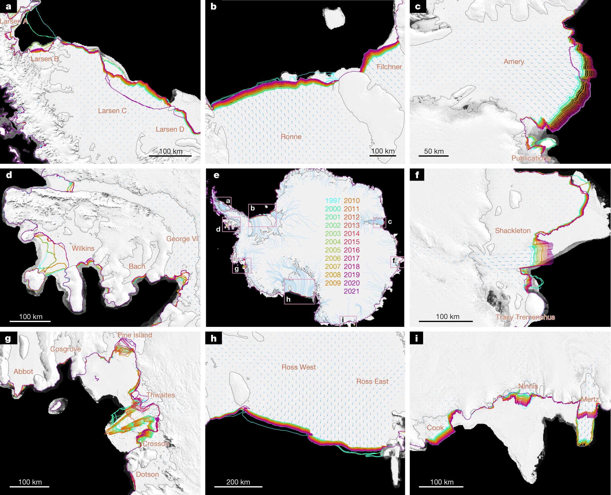
Antarctica’s ice shelves help to control the flow of glacial ice as it drains into the ocean, meaning that the rate of global sea-level rise is subject to the structural integrity of these fragile, floating extensions of the ice sheet. Until now, data limitations have made it difficult to monitor the growth and retreat cycles of ice shelves on a large scale, and the full impact of recent calving-front changes on ice-shelf buttressing has not been understood. Here, by combining data from multiple optical and radar satellite sensors, we generate pan-Antarctic, spatially continuous coastlines at roughly annual resolution since 1997. We show that from 1997 to 2021, Antarctica experienced a net loss of 36,701 ± 1,465 square kilometres (1.9 per cent) of ice-shelf area that cannot be fully regained before the next series of major calving events, which are likely to occur in the next decade. Mass loss associated with ice-front retreat (5,874 ± 396 gigatonnes) has been approximately equal to mass change owing to ice-shelf thinning over the past quarter of a century (6,113 ± 452 gigatonnes), meaning that the total mass loss is nearly double that which could be measured by altimetry-based surveys alone. We model the impacts of Antarctica’s recent coastline evolution in the absence of additional feedbacks, and find that calving and thinning have produced equivalent reductions in ice-shelf buttressing since 2007, and that further retreat could produce increasingly significant sea-level rise in the future.​

Spoiler Legend :
a,d, The Larsen (a) and Wilkins (d) ice shelves of the Antarctic Peninsula have retreated in a stair-step series of events over the past quarter of a century. b,h, Antarctica’s largest ice shelves Ronne (b) and Ross (h) experienced major calving events in 2000 and 2002 and have since steadily advanced until the May 2021 calving of iceberg A76, not shown here. g, Thwaites Glacier is perhaps the most difficult coastline to track, as its thick and broken iceberg tongue remained semi-connected to the ice shelf for several years. i, A sequence of events is seen at Mertz Glacier Tongue, whose tip touched ground on the western side48, pushing the tongue to the east until the tip broke off in 2010, and the ice shelf has been advancing towards the west again ever since. Meanwhile, nearby Cook Ice Shelf has steadily advanced throughout the entire period of observation. Panels c, e and f show the Amery Ice Shelf, a map indicating the locations of insets, and Shackleton Ice Shelf, respectively.


Spoiler Graph of loss of different places :

Spoiler Legend :
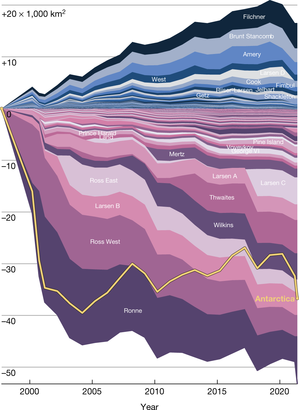
Among Antarctica’s 181 ice shelves surveyed in this study, 118 (shown in pink/purple tones) have lost a total of 54,029 ± 634 km2 since 1997, whereas only 63 ice shelves (shown in blue tones) grew in extent by 17,781 ± 438 km2. The Ronne and Ross ice shelves together account for 29% of gross losses (15,678 ± 263 km2), and the Filchner and Amery ice shelves together account for 41% of gross gains (7,303 ± 139 km2). The gold line shows a net loss of 36,701 ± 1,465 km2 for all of Antarctica, including 454 ± 1,245 km2 loss from coastal areas that do not terminate in named ice shelves. It is noted that ice-shelf area anomalies correspond to their visible areas rather than distance from the zero axis, so the downward shifts seen in many ice shelves towards the lower end of the figure in 2010 and 2017 correspond to major calving events at Mertz and Larsen C, respectively. Also, it is noted that the relative influence of the largest outliers such as the Ronne, Ross West and Filchner ice shelves can be effectively removed by ignoring them when visually inspecting this figure.

 
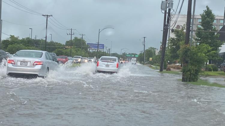
A Harris County, TX meteorologist says parts of Dallas-Forth Worth recorded 13.94"/35.4cm of rain in 12 hours last night. Dallas-Ft Worth International Airport recorded 7.17" / 18.2cm of rain in 24 hours, the 5th-most rain in a single day in 122 years of records. Their average rainfall for the months of July, August & September combined is 6.98".

Dallas, last night:


Someone on the radio just said that Dallas got 7"/17.8cm in 3 hours. It was unclear to me if that was on top of what I cited above, or if that was the rain at its fiercest overnight (that is, of the 14" that fell over 12 hours, maybe 7 of them fell in a 3-hour period). Either way, that's insane. I read somewhere else that Ft. Worth 911 got 50+ calls related to high water between 10pm and 5am last night. A reporter said he saw a woman swimming out of her car, after she got caught in a flash-flood. It's good she knew how to swim, I guess.
 
Someone on the radio just said that Dallas got 7"/17.8cm in 3 hours. It was unclear to me if that was on top of what I cited above, or if that was the rain at its fiercest overnight (that is, of the 14" that fell over 12 hours, maybe 7 of them fell in a 3-hour period). Either way, that's insane. I read somewhere else that Ft. Worth 911 got 50+ calls related to high water between 10pm and 5am last night. A reporter said he saw a woman swimming out of her car, after she got caught in a flash-flood. It's good she knew how to swim, I guess.
I live in Dallas, and I can indeed confirm that half the city was pretty much flooded out. Driving to work was an interesting experience. And then I got sent home when no one else showed up.
 
Top Bottom