• Our friends from AlphaCentauri2.info are in need of technical assistance. If you have experience with the LAMP stack and some hours to spare, please help them out and post here.

[Development] Alternative Map during 1.17

All right, here are two more updates.

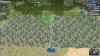
The first option fixes the Oregon coast, to put Portland directly on the Pacific and with a proper shape for the Columbia River. (I highlighted the five tiles of new land, along with the new location of Mt. Rainier, as well as the new placement for Vancouver and Victoria.)
Spoiler Oregon fix :
civmap-pnw-change3-16-tiles-png.528649


The second option goes back to the original version, and simply adds three tiles along the coast. It leaves the Columbia River flat, but it does add a Willamette River, along with a tile for the Olympic Peninsula and a Puget Sound. I prefer the one above, because it creates a bit more distance between Seattle and Portland, and permits both cities to be settled. However, if you want to limit the size of the PNW, this 'minimalist' version does the job.
Spoiler Minimalist fix :
civmap-pnw-change3-13-tiles-png.528648


Thoughts?
I quite like those. Thanks for putting so much effort into this part of the map and for trying a few different approaches! (I also live in the Pacific Northwest, so even if it's not the most important part of the map, it's fun discussing somewhere I know pretty well.)

I think I prefer the first one as well, but what is being sacrificed for the extra tiles? Is somewhere else in North America smaller, or is the whole coast pushed north or south? Just want to be aware of how this affects the surrounding areas.
 
Spoiler PNW :
79ECA64D-D883-44AC-A770-A825EABD9BB4.jpeg

Ignore the resources, what do you think about this if Vancouver was pushed 1w?
The dilemma in the PNW is similar to the east coast, we have three major cities but if realistically placed it gets a bit crowded. In this example, Seattle and Portland are separated by 2 tiles while Vancouver gets only one. Given the distances in real life this is fairly accurate but it ends up crowding Vancouver.
If we move it one west it can reach further out on the coast, perhaps we can align the resources in a way in which all cities feel needed.
 
Spoiler PNW :

Ignore the resources, what do you think about this if Vancouver was pushed 1w?
The dilemma in the PNW is similar to the east coast, we have three major cities but if realistically placed it gets a bit crowded. In this example, Seattle and Portland are separated by 2 tiles while Vancouver gets only one. Given the distances in real life this is fairly accurate but it ends up crowding Vancouver.
If we move it one west it can reach further out on the coast, perhaps we can align the resources in a way in which all cities feel needed.

Keeping Vancouver further out is more accurate to real life geography, I think.
It's also more important to space Vancouver out from Seattle than Portland IMO, since they'll normally belong to two different civs and so cultural pressure against each other becomes more of a factor in how viable they are (and whether or not they'll even be settled).
 
what is being sacrificed for the extra tiles? Is somewhere else in North America smaller, or is the whole coast pushed north or south? Just want to be aware of how this affects the surrounding areas.
For the 'three extra tiles' version, nothing is being sacrificed -- it's just added three tiles where there used to be ocean (and those three tiles should be land anyway).

For the five extra tiles version, the one we both prefer -- that requires pushing Vancouver 1N, to give Seattle more distance from Portland. It doesn't affect the rest of the continental US (Seattle should be at the same latitude as Spokane anyway), but it does shrink the northern part of British Columbia, which affects some of the mountain placement. I also had to reduce the Frasier River by a tile to match (the northern part of the province is dominated by the Peace River, which ultimately joins the Mackenzie river and flows north into the Arctic Ocean. Apart from that, no other effects.

Ignore the resources, what do you think about this if Vancouver was pushed 1w?
I'm having trouble figuring out the screenshot, to see how much you changed from the original map -- it looks like you added the same three land tiles I did along the Pacific Coast, then added another two land tiles due north of Seattle so you could move that city 1N, and moved Vancouver Island 1W so it's still separated from the mainland.

The problem is, this adds the same number of land tiles (5) as my proposal, without fixing the basic issue that the three key cities are too cramped. As DC-stringofnumbers says, it's more important to provide space between Vancouver and Seattle than between Seattle and Portland, and your proposal pushes the first two cities even closer together.

Or were you suggesting taking your map, and pushing Vancouver 1W from that point? That'd give the city a bit more room, and reconnect Vancouver Island to the mainland (I like the idea of having islands be islands, but if it's disconnected, those two tiles will be the last to be improved, since the player would need to keep a ship nearby to ferry the workers back and forth). But it'd still have the same problems, of having Vancouver in Seattle's BFC.
 
I'm in favor of pushing Vancouver North and fixing the surrounding tiles accordingly to make it a viable city (ie, remove some of the mountains). On the other hand (and in contrast to the case of Colombia and Venezuela that we were discussing in the other thread), the US doesn't need additional land at all. Eastern Washington and Oregon would be mostly empty space, right? I'm not sure in that case that it's really necessary to push the coast further out. It would be also be great to see how the extra land looks with North America as a whole, not just zoomed in in there, to get a better sense of proportions. I think you tried earlier overlaying a real map over the game map, just try that again but see how it looks for the country as a whole, not only this section, so you keep the proportions. If necessary to make the cities viable, then I think it's better to fix the area inland than to expand out, but I'm also ok with seeing the three cities close to each other - since that's what happens in reality and what we've accepted in many other places of the world.
 
Keeping Vancouver further out is more accurate to real life geography, I think.
It's also more important to space Vancouver out from Seattle than Portland IMO, since they'll normally belong to two different civs and so cultural pressure against each other becomes more of a factor in how viable they are (and whether or not they'll even be settled).
I second this. From a gameplay perspective it's more important that Vancouver have the space. On the current map settling Seattle almost always means Vancouver is never founded. Vancouver is also far more important to Canada than Portland is to the US so I'd say 2 tiles between Seattle and Vancouver is higher priority than 2 tiles between Portland and Seattle even though in reality Vancouver is closer to Seattle than Seattle to Portland. There happens to be quite a bit of space between Portland and San Francisco too.
 
Looking at this again, it might look even more natural if the new taiga variety would not just consist of these new most snow covered trees but would also include some of the more snow covered trees from the cold forest variety.

Something like this?

I made 2 versions (seperated by the river) because I thought the ratio snowy vs very snow trees was different. But it is about 50%, so there is no real difference between them.

Spoiler :
civ4screenshot0212-jpg.528684
 

Attachments

  • Civ4ScreenShot0212.JPG
    Civ4ScreenShot0212.JPG
    682.1 KB · Views: 1,716
Yeah, both look good (I can't really discern a difference between them), and I think they will still look very different than the cold forest variety. I'll be happy to take a PR for this.
 
There isn't really a difference. I just swapped the taiga trees with the snowy trees. I thought that the normal snowy forest had something like a 30-70 split between snowy forest and very snowy trees. So I thought that one version had more taiga trees and the other one more snowy forest trees. But the ratio is 50-50 so both versions have the same ratio.

I will make a PR.
EDIT: PR has been made.
 
Last edited:
Keeping Vancouver further out is more accurate to real life geography, I think.
It's also more important to space Vancouver out from Seattle than Portland IMO, since they'll normally belong to two different civs and so cultural pressure against each other becomes more of a factor in how viable they are (and whether or not they'll even be settled).
I do like this kind of... my only problems remaining being that Victoria is in Seattles sphere, the upper half of Vancouver Island is outside of Vancouver's sphere now and Vancouver/Seattle are too close. Solve the problem by moving Seattle canonical 1S and move deer 1S to avoid super city Seattle. But then Seattle is on the Columbia River. Remove the bend from the Columbia River so that Seattle is not on the Columbia, it's actually not that big a bend in reality anyway. Move Portland canonical 1W to the coast (where the deer was). It's still well out of the way of San Francisco. I like this situation. It gives me the opportunity to found an utterly useless Boise, ID (though I'd move the potato 1E to do that).

Can we get a look at what your Northern British Columbia might look like?

EDIT: If it wasn't clear I meant to reply to Tab... oops
 
Last edited:
Having two tiles between Vancouver and Seattle is important because on longer game speeds the US will build Seattle and the BFC will expand outwards covering Vancouver before the Canadians can settle it. Attaching Vancouver Island to the Mainland is probably best as it will allow Vancouver to work it for production, and because Victoria is at the SE tip, that area would be obscenely crowded with Victoria, Vancouver and Seattle.
 
Merged a pull request by merijn_v1: new taiga art, farms enable Millet
 
New update:
- adjusted terrain in Scandinavia
- adjusted terrain in Russia
- adjusted terrain in Central Asia

No details this time, but most of it is based on Finbros's posts. There also have been more suggestions for Scandinavia after I did this (weeks ago), so expect more.

Also, I mistakenly amended a commit I had already pushed, please use "git pull --rebase" or delete and fetch the branch again if you have already pulled recently. Sorry for the trouble.
 
Merged a pull request by merijn_v1: improved bamboo forest texture, additional taiga feature variety
 
New update:
- adjusted terrain in Siberia
- adjusted terrain in Scandinavia

Here's the tour for the last two updates:
Spoiler :
Civ4ScreenShot0063.JPG
Civ4ScreenShot0064.JPG
Civ4ScreenShot0065.JPG
Civ4ScreenShot0066.JPG
Civ4ScreenShot0067.JPG
Civ4ScreenShot0068.JPG
Civ4ScreenShot0069.JPG
Civ4ScreenShot0070.JPG
Civ4ScreenShot0071.JPG
 
New update:
- New York tile is a lagoon
- adjusted seafood at the American east coast
- adjusted terrain in the Caribbean

Spoiler :
Civ4ScreenShot0072.JPG
Civ4ScreenShot0073.JPG
 
New update:
- adjusted terrain in Britain
- adjusted terrain in Iberia

Spoiler :
Civ4ScreenShot0074.JPG

- added coal in southern Ireland and North England
- moved English horses 1W of London
- replaced English deer with sheep
- added salt in Cheshire
- removed wheat in England

This should gear the resources on the islands more toward medieval England with subpar food supply and a strong wool industry, plus a lot of coal to kick off the Industrial revolution. London should get food resource spawns later in the game.

Spoiler :
Civ4ScreenShot0076.JPG

- added stone in Andalusia
- moved seafood around
- moved Castilian iron 1W
- added some additional forests

Edit: forgot to mention some stuff in Germany:
- added the Moselle river
- replaced marble at the Rhine with wine
- added wine at the Danube
 
Last edited:
Few trivial ideas for England.
Salt lies in densely populated place, town might look better here to represent Birmingham.
To replace that one health bonus crab resource could be added, as I found out reading on wikipedia "N. norvegicus is mostly caught by trawling. Around 60,000 tonnes are caught annually, half of it in the United Kingdom's waters" and "In 2008, 4,386 t of H. gammarus were caught across Europe and North Africa, of which 3,462 t (79%) was caught in the British Isles (including the Channel Islands)." (https://en.wikipedia.org/wiki/Lobster_fishing)
And according to map they could replace already present fish.
Spoiler :

LobsdistFAO.png


That one fish if needed could be placed somewhere near northern England to help (earlier) York or (later) Manchester and Liverpool.
 
@merijn_v1 I have tried your new tropical forest variant and it also shows some kind of flickering. Almost as if the contrast between individual pixels is too high and when animation occurs the visual impression becomes very busy. This isn't only showing up when the trees are moving from the wind, but even more pronounced when you quickly zoom out right below the zoom level where clouds become visible. I'm seeing this with the tropical and bamboo forest variants (both for trees and bamboo stalks) as well as for both taiga varieties. It does not show up for the mixed forest variety you've made.

I think this definitely needs to be investigated because as it is this leads to quite some eye strain, in particular when the map is further zoomed out. I'm not sure what the source of this is but I would expect shading or maybe the alpha channel?
 
Back
Top Bottom