Krieger-FS
Warlord
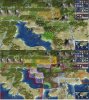
About the Brazilian Southeast, with the original map bellow.

Before discuss the changes that I'm proposing, I wanna highlight some guidelines. This region would be probably the core of Brazilan civilization, with the largest and most productive cities. After the decline of sugar economy on Northeast following the increasing Caribbean competition, almost all economic cycles of relevance ocurred in this area, starting with the gold and precious metal production in Minas Gerais during the 18th century, the coffe by the 19th to mid-20th century and the industrialization (both centered mostly in São Paulo) starting by the 1930s. In political terms, the colonial administrative center was transferred from Salvador to Rio de Janeiro in mid-18th century; the city was also briefly the capital of the Portuguese Empire in 1808-1821. With the independance (which the region in a whole supported), Rio became capital of Brazilian Empire and was the largest city during much of the 19th and early 20th centuries. With the establishment of the republic, in 1889, the political balance shifted to Minas Gerais (then the most populous state) and São Paulo, both which maintained an informal alliance which ruled the country until 1930. Since then, São Paulo became the most populous, industrial and wealthy state (42 million people) in Brazil, with Minas (20 million) and Rio (17 million) following. As such, one of my guidelines in doing the changes here was to allow at least three big cities.
My suggestions are these:

1) Added a land title 1NW of Rio de Janeiro. I think that it didn't affect the shape of the continent much and, on the positive side, offers a precious title of land to Rio work.
2) rearranged the mountains and included several hills to make more geographically accurate. Minas Gerais is a quite hilly state, with mountain ranges in the borders with São Paulo, Rio and Espírito Santo and some of the highest peaks in the country.
3) I've also rearranged the rivers. Made the Paraná river and its tributaries more lookalike its real course, including the rivers (from north to south) Parnaíba, Grande, Tietê and Paranapanema. These rivers are the main tributaries of Paraná river and are important waterways with several hydroplants; they also define the borders between the states of Goiás, Minas Gerais, São Paulo and Paraná. The inclusion of Tietê is also relevant for both historical and gameplay reasons. The river was the most important inland waterway during the time of bandeirantes explorations, which eventually led to the expansion of the colony to nowadays inland Brazil, and its also today used as a waterway to connect the grain-producing states in Central-West region with the port of Santos (the largest and most important of the country). Gameplay-wise, the inclusion of the river helps São Paulo become the production powerhouse it should be.
4) changed grasslands and plains to make the distinction between vegetation the region. In the coastal region we have the Atlantic Forest, which originally covered most of Brazil's coastal regions. It suffered extensive deforestion in the last centuries, which is why is mostly represented by trees and not rainforest (as a side-effect in gameplay perspective, also helps the development of the cities). The plain titles represent the Cerrado, a savanna-like vegetation common in all central Brazil.
Resources:

Pre-colonial:
Dyes (1N of Vitória): represents the Brazilwood exploration and is already discussed in the post above.
Gems (1NE of Belo Horizonte): represents diamond mining in the region around Diamantina. Developed only during colonial times (17th-18th centuries) these were one of the most important products explored in Brazil by that time. In fact, the operations here were so huge that the Portuguese crown directly tried to control the mining to avoid overproduction and decreased prices. Most of the diamond mines are nowadays exhausted, although there are still some mining of semi-precious stones.
Gold (1E of Belo Horizonte): represents the gold found by the bandeirantes in late 17th century that triggered the colonization and economic mining cycle based in Minas Gerais. By the 18th century Minas was the most populous and prosperous region in the colony.
Iron (1W of Belo Horizonte): represents the large iron reserves in central Minas Gerais, which were historically speaking the main region of iron ore mining in Brazil.
Fish (2E of Rio de Janeiro): In the original map there was a crab resource close. There is commercial fishing in this area and, gameplay wise, it also helps Rio to grow to the appropriate size.
Colonial:
Sugar (2W of São Paulo): Some of the oldest (and even the first) Portuguese cities in the Americas were located in coast of São Paulo and had a somewhat successful colonial economy based on sugar production in 16th century. Sugar plantations continued to exist in the state area during the following centuries and with the decline of coffe economy by the 1950s, São Paulo's farming focused again in sugar and the state became the leading producer in Brazil today, especially in the ethanol production.
Cattle (1S of Belo Horizonte): represents both the cattle production during colonial times and the dairy production in Minas Gerais since 19th century. As a fun-fact, the first Brazilian republic (1889-1930) was nicknamed Coffe with Milk because it was politically dominated by São Paulo (coffe) and Minas (milk).
Coffe (1NE of Rio de Janeiro): represents the oldest areas of coffe production (18th century) in Rio de Janeiro/Espírito Santo states.
Post-independence and modern:
2 Coffe (1NW and 3W of São Paulo): São Paulo became the leading producer of coffe in the world in late 19th and first half of 20th centuries.
Bananas (1SW of São Paulo): if I recall correctly, there was a bananas spawn here in the old map. I think that the main ideia is to represent the food production in São Paulo (the state is an important producer of beens, rice, cassava, corn, orange and other cultures) and allow the city to grow appropriately, thus, it could be also any other food resource. Even though, the bananas are located in a historically correct area, as the southern São Paulo state is known for this production. Either way, I think that the resource should spawn only in post-independence era (1800 CE), as São Paulo was a relatively small city until mid-late 19th century.
Aluminium (1SW of Belo Horizonte): Brazil has some of the largest bauxite reserves in the world; many of the mines are located in Minas.
Rare Earths (1NW of Belo Horizonte) : represents the reserves of those materials in Brazil. These mining operations were only devolped during WW2, as the alliance treaty with US specified that Brazil would supply the american war industry with those materials. Brazil was one of the leading producers of rare earth in the 1940s and still has some reserves nowadays.
Oil (2S1E of Rio de Janeiro): represents the main oil-producing areas in Brazil, where are located the largest reserves on seabed. It became quite important since late 1970s and Brazil today is one of the major crude oil producers in the world.
Spoiler :
Before discuss the changes that I'm proposing, I wanna highlight some guidelines. This region would be probably the core of Brazilan civilization, with the largest and most productive cities. After the decline of sugar economy on Northeast following the increasing Caribbean competition, almost all economic cycles of relevance ocurred in this area, starting with the gold and precious metal production in Minas Gerais during the 18th century, the coffe by the 19th to mid-20th century and the industrialization (both centered mostly in São Paulo) starting by the 1930s. In political terms, the colonial administrative center was transferred from Salvador to Rio de Janeiro in mid-18th century; the city was also briefly the capital of the Portuguese Empire in 1808-1821. With the independance (which the region in a whole supported), Rio became capital of Brazilian Empire and was the largest city during much of the 19th and early 20th centuries. With the establishment of the republic, in 1889, the political balance shifted to Minas Gerais (then the most populous state) and São Paulo, both which maintained an informal alliance which ruled the country until 1930. Since then, São Paulo became the most populous, industrial and wealthy state (42 million people) in Brazil, with Minas (20 million) and Rio (17 million) following. As such, one of my guidelines in doing the changes here was to allow at least three big cities.
My suggestions are these:
Spoiler :
1) Added a land title 1NW of Rio de Janeiro. I think that it didn't affect the shape of the continent much and, on the positive side, offers a precious title of land to Rio work.
2) rearranged the mountains and included several hills to make more geographically accurate. Minas Gerais is a quite hilly state, with mountain ranges in the borders with São Paulo, Rio and Espírito Santo and some of the highest peaks in the country.
3) I've also rearranged the rivers. Made the Paraná river and its tributaries more lookalike its real course, including the rivers (from north to south) Parnaíba, Grande, Tietê and Paranapanema. These rivers are the main tributaries of Paraná river and are important waterways with several hydroplants; they also define the borders between the states of Goiás, Minas Gerais, São Paulo and Paraná. The inclusion of Tietê is also relevant for both historical and gameplay reasons. The river was the most important inland waterway during the time of bandeirantes explorations, which eventually led to the expansion of the colony to nowadays inland Brazil, and its also today used as a waterway to connect the grain-producing states in Central-West region with the port of Santos (the largest and most important of the country). Gameplay-wise, the inclusion of the river helps São Paulo become the production powerhouse it should be.
4) changed grasslands and plains to make the distinction between vegetation the region. In the coastal region we have the Atlantic Forest, which originally covered most of Brazil's coastal regions. It suffered extensive deforestion in the last centuries, which is why is mostly represented by trees and not rainforest (as a side-effect in gameplay perspective, also helps the development of the cities). The plain titles represent the Cerrado, a savanna-like vegetation common in all central Brazil.
Resources:
Spoiler :
Pre-colonial:
Dyes (1N of Vitória): represents the Brazilwood exploration and is already discussed in the post above.
Gems (1NE of Belo Horizonte): represents diamond mining in the region around Diamantina. Developed only during colonial times (17th-18th centuries) these were one of the most important products explored in Brazil by that time. In fact, the operations here were so huge that the Portuguese crown directly tried to control the mining to avoid overproduction and decreased prices. Most of the diamond mines are nowadays exhausted, although there are still some mining of semi-precious stones.
Gold (1E of Belo Horizonte): represents the gold found by the bandeirantes in late 17th century that triggered the colonization and economic mining cycle based in Minas Gerais. By the 18th century Minas was the most populous and prosperous region in the colony.
Iron (1W of Belo Horizonte): represents the large iron reserves in central Minas Gerais, which were historically speaking the main region of iron ore mining in Brazil.
Fish (2E of Rio de Janeiro): In the original map there was a crab resource close. There is commercial fishing in this area and, gameplay wise, it also helps Rio to grow to the appropriate size.
Colonial:
Sugar (2W of São Paulo): Some of the oldest (and even the first) Portuguese cities in the Americas were located in coast of São Paulo and had a somewhat successful colonial economy based on sugar production in 16th century. Sugar plantations continued to exist in the state area during the following centuries and with the decline of coffe economy by the 1950s, São Paulo's farming focused again in sugar and the state became the leading producer in Brazil today, especially in the ethanol production.
Cattle (1S of Belo Horizonte): represents both the cattle production during colonial times and the dairy production in Minas Gerais since 19th century. As a fun-fact, the first Brazilian republic (1889-1930) was nicknamed Coffe with Milk because it was politically dominated by São Paulo (coffe) and Minas (milk).
Coffe (1NE of Rio de Janeiro): represents the oldest areas of coffe production (18th century) in Rio de Janeiro/Espírito Santo states.
Post-independence and modern:
2 Coffe (1NW and 3W of São Paulo): São Paulo became the leading producer of coffe in the world in late 19th and first half of 20th centuries.
Bananas (1SW of São Paulo): if I recall correctly, there was a bananas spawn here in the old map. I think that the main ideia is to represent the food production in São Paulo (the state is an important producer of beens, rice, cassava, corn, orange and other cultures) and allow the city to grow appropriately, thus, it could be also any other food resource. Even though, the bananas are located in a historically correct area, as the southern São Paulo state is known for this production. Either way, I think that the resource should spawn only in post-independence era (1800 CE), as São Paulo was a relatively small city until mid-late 19th century.
Aluminium (1SW of Belo Horizonte): Brazil has some of the largest bauxite reserves in the world; many of the mines are located in Minas.
Rare Earths (1NW of Belo Horizonte) : represents the reserves of those materials in Brazil. These mining operations were only devolped during WW2, as the alliance treaty with US specified that Brazil would supply the american war industry with those materials. Brazil was one of the leading producers of rare earth in the 1940s and still has some reserves nowadays.
Oil (2S1E of Rio de Janeiro): represents the main oil-producing areas in Brazil, where are located the largest reserves on seabed. It became quite important since late 1970s and Brazil today is one of the major crude oil producers in the world.
Last edited: