Crimean Lord
Warlord
One of those unrecognised Russian puppet states I presume.
Right!
ABHAZIA was muslim province of Georgia with powerfull separatists movement - and in the same time it's mountain border between Russia and Georgia
One of those unrecognised Russian puppet states I presume.
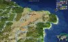
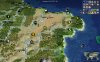
It's GeorgiaWhat is the orange country on your map?
")
What is the orange country on your map?
One of those unrecognised Russian puppet states I presume.
Ahh, Georgia... not so obvious to me the shape and position seemed off. I didn't even notice the tiny Gold spot.. but then what is the purple? I figured that was Georgia as it was closest to Russia, while it seemed a bit small and far north the shape (long, wedge-like) seemed more Georgia-y. Is that Abkhazia? When you put orange and purple together I really don't get the sense of the recognized borders of Georgia. Hence my confusion.
Thanks for clarifying! I knew about South Ossetia and Abkhazia being hotly disputed, but this is the first time I'm hearing about Artsakh.The thing that's tripping you guys up is that the map includes nations that are in practice sovereign, but most other nations don't recognize them.
Thanks for clarifying! I knew about South Ossetia and Abkhazia being hotly disputed, but this is the first time I'm hearing about Artsakh.
Ay! I mean Orange + Green doesn't equal (internationally recognized) Georgia to me.** Purple is obviously Armenia and brown obviously Azerbaijan it was the Orange/Green that was tripping me up. Either Georgia is too North and too small (if it were green) and there is a new massive Caucasus state (orange) I haven't heard of or Abkhazia (green) is too big and Georgia (orange) is oddly shaped. I guess the borders are pretty hard to accurately represent as it's pretty tight.Ahh, Georgia... not so obvious to me the shape and position seemed off. I didn't even notice the tiny Gold spot.. but then what is the purple? I figured that was Georgia as it was closest to Russia, while it seemed a bit small and far north the shape (long, wedge-like) seemed more Georgia-y. Is that Abkhazia? When you put orange and purple together I really don't get the sense of the recognized borders of Georgia. Hence my confusion.
Thanks for clarifying! I knew about South Ossetia and Abkhazia being hotly disputed, but this is the first time I'm hearing about Artsakh.
Do you still have your art defines for the atolls with the sandbanks using vanilla coast textures?A test with some sandbanks. I used the vanilla coast texture, so it is a bit lighter than the coast used in DoC.
It does give an ugly border when you add a land tile next to it. It can be masked a bit by rainforests and cities.
Spoiler :
And the Venice Lagoon.
Spoiler :
The Tenochtitlan lagoon looks similar to stebs image.
EDIT:
This is with the DoC coast texture for reference.
Spoiler :
        <TerrainArtInfo>
            <Type>ART_DEF_TERRAIN_LAGOON</Type>
            <Path>Art/Terrain/Textures/lagoonBLEND.dds</Path>
            <Grid>Art/Terrain/Textures/lagoonGrids.dds</Grid>
            <Detail>Art/Terrain/Textures/lagoonDetail.dds</Detail>
            <Button>,Art/Interface/Buttons/BaseTerrain/Coast.dds,Art/Interface/Buttons/BaseTerrain_TerrainFeatures_Atlas.dds,1,1</Button>
            <LayerOrder>6</LayerOrder>
            <AlphaShader>0</AlphaShader>
            <TextureBlend01>1,180 5,270 9,180  13,270 17,180 21,270 26,270</TextureBlend01>
            <TextureBlend02>1,270 5,0   9,270  13,0   17,270 21,0   26,0</TextureBlend02>
            <TextureBlend04>1,0   5,90  9,0    13,90  17,0   21,90  26,90</TextureBlend04>
            <TextureBlend08>1,90  5,180 9,90   13,180 17,90  21,180 26,180</TextureBlend08>
            <TextureBlend03>3,0   7,180 11,0   15,180 19,0   23,180 27,0   31,180</TextureBlend03>
            <TextureBlend06>3,90  7,270 11,90  15,270 19,90  23,270 27,90  31,270</TextureBlend06>
            <TextureBlend12>3,180 7,0   11,180 15,0   19,180 23,0   27,180 31,0</TextureBlend12>
            <TextureBlend09>3,270 7,90  11,270 15,90  19,270 23,90  27,270 31,90</TextureBlend09>
            <TextureBlend07>4,0   8,270 12,0   16,270 20,0   24,270 28,0   32,270</TextureBlend07>
            <TextureBlend14>4,90  8,0   12,90  16,0   20,90  24,0   28,90  32,0</TextureBlend14>
            <TextureBlend13>4,180 8,90  12,180 16,90  20,180 24,90  28,180 32,90</TextureBlend13>
            <TextureBlend11>4,270 8,180 12,270 16,180 20,270 24,180 28,270 32,180</TextureBlend11>
            <TextureBlend10>2,0   6,90  10,0   14,90  18,0   22,90  </TextureBlend10>
            <TextureBlend05>2,90  6,0   10,90  14,0   18,90  22,0   </TextureBlend05>
            <TextureBlend15>29,0 </TextureBlend15>
</TerrainArtInfo>Thanks! A pull request on the map branch would be even better.Copy the ART_DEF of the coast, change the <LayerOrder> to 6 and copy and use the textures from the vanilla game. (IIRC they are in the FPK files of vanilla Civ4)
I can make a PR on the newmap branch if you want.
Code:<TerrainArtInfo> <Type>ART_DEF_TERRAIN_LAGOON</Type> <Path>Art/Terrain/Textures/lagoonBLEND.dds</Path> <Grid>Art/Terrain/Textures/lagoonGrids.dds</Grid> <Detail>Art/Terrain/Textures/lagoonDetail.dds</Detail> <Button>,Art/Interface/Buttons/BaseTerrain/Coast.dds,Art/Interface/Buttons/BaseTerrain_TerrainFeatures_Atlas.dds,1,1</Button> <LayerOrder>6</LayerOrder> <AlphaShader>0</AlphaShader> <TextureBlend01>1,180 5,270 9,180 13,270 17,180 21,270 26,270</TextureBlend01> <TextureBlend02>1,270 5,0 9,270 13,0 17,270 21,0 26,0</TextureBlend02> <TextureBlend04>1,0 5,90 9,0 13,90 17,0 21,90 26,90</TextureBlend04> <TextureBlend08>1,90 5,180 9,90 13,180 17,90 21,180 26,180</TextureBlend08> <TextureBlend03>3,0 7,180 11,0 15,180 19,0 23,180 27,0 31,180</TextureBlend03> <TextureBlend06>3,90 7,270 11,90 15,270 19,90 23,270 27,90 31,270</TextureBlend06> <TextureBlend12>3,180 7,0 11,180 15,0 19,180 23,0 27,180 31,0</TextureBlend12> <TextureBlend09>3,270 7,90 11,270 15,90 19,270 23,90 27,270 31,90</TextureBlend09> <TextureBlend07>4,0 8,270 12,0 16,270 20,0 24,270 28,0 32,270</TextureBlend07> <TextureBlend14>4,90 8,0 12,90 16,0 20,90 24,0 28,90 32,0</TextureBlend14> <TextureBlend13>4,180 8,90 12,180 16,90 20,180 24,90 28,180 32,90</TextureBlend13> <TextureBlend11>4,270 8,180 12,270 16,180 20,270 24,180 28,270 32,180</TextureBlend11> <TextureBlend10>2,0 6,90 10,0 14,90 18,0 22,90 </TextureBlend10> <TextureBlend05>2,90 6,0 10,90 14,0 18,90 22,0 </TextureBlend05> <TextureBlend15>29,0 </TextureBlend15> </TerrainArtInfo>