[Development] Map Suggestions

We do have coal and rare earths within reach of Baotou. The idea that economic growth rather than surrounding food should determine a city's size has been brought up multiple times but that's just not how Civ4 works. I have some ideas on how to reflect this somewhat better by having a better trade/corporations system, but there's a lot of stuff that's higher on the priority list even though I'd love to do it.
Wouldn't the effect of converting trade route commerce to food be a thematically Civ 4 way of doing just that? Perhaps swapping that out with Supermarket's current effect?
 
To be clear, I still think that food should determine city size. I'm more interested in the idea of a "new era" of buildings. Something like rare earths needed to produce hardware and then hardware + a city with a certain level of infrastructure or trade routes can produce software.
I was just wondering if there was a system to better reflect the importance of tech in the modern economy. The most productive cities in the late game should be based upon trade routes, finance and education, not factories and raw materials. ie: a late-game postindustrial shift for developed countries.

Nice as it sounds, we also have to remember that in a game of civ, this is a complete paradigm shift for only the last 50 some years of gameplay. I reckon this is an idea that should be shelved along with concepts for late-game/future expansion. It doesn't make sense to implement anything if we aren't planning games to extend into beyond 2100 or so.
Perhaps such a goal would be better reached with the planned trade route overhaul? IIRC there's vague and tentative plans to tie trade route commerce into corporations and culture. That- combined with Multilateralism- would create a rather organic implementation of deriving production from economic prosperity.

Science contributing to production is a different story however. I'm not quite sure how this could be accomplished in a Civ 4 style. I can't think of a single mechanic that can convert a non-trade route derived Commerce Type to a Yield Type.
 
Last edited:
Is there any reason Hainan is so small? In reality, it's fairly big: it has about the same area as Taiwan, to which we've given four tiles! Hainan probably doesn't need four tiles, but I feel it deserves a second one, 1E of the current Hainan tile. Maybe we don't want to emphasize it because it is not so important historically. But still, its size is very inaccurate right now.

I'm also not sure how well it would fit with its surroundings. But perhaps the surroundings aren't that well designed yet. The Pearl River delta, right now, occurs immediately north of Hainan (and thus directly north of the Vietnam coastline). This is incorrect. The Pearl River delta, Hong Kong, Guangzhou, etc. are located roughly directly north of the middle of the South China Sea. I define "middle" as being the point that is equidistant to Vietnam and Luzon island.

The mouth of the Pearl River should definitely be moved at least 1E and possibly 2E. This would most likely require an addition land tile (for Hong Kong?). It could also be made more delta-y by adding a secondary branch. Here's a rough suggestion:
Spoiler :
Civ4ScreenShot0144.jpg
 
Does anyone know what is up with the silver in Catalonia? I could not find anything related to silver mining in that area. Phoenicians and Romans indeed colonised Iberia for its silver resources, and I actually found some information about how the stability of the Roman currency strongly depended on the influx of Iberian silver, but that's all about the silver source at Riotinto (i.e. in Andalusia, where the olives currently are). I know this carried over from the current map, but is there any point to it?
 
I looked into it a bit and there are indeed silver-lead deposits in Tarragona (https://www.researchgate.net/public...direct_Proofs_based_on_Lead_Isotopes_Analysis), however they were probably only used for producing lead in antiquity (too low silver content for the technology of that time).

Anyway, I definitely think that there should be at least one silver in southern Iberia during the classical era. Apart from Riotinto, the area around Cartagena was a major silver mining center (reputed to have been worked by 40,000 slaves).
 
Turk spawn is bugged, making game stuck there. I pressed enter key and got a catapult for my French.

Tried another Chinese game, the map grew huge and China became too empty while being large. We should add more indy & barb cities in ancient & classical era. Until now, China is just about farming until northern barbs appear, then ready for Mongols. No real threats including Turks. That makes the game somehow easy and boring.

If we want a more intense game, there should be more conquest in ancient and classical era. I suggest a new wonder or project:

The Nine Cauldron (九鼎)
Requires writing
Expires with feudalism or civil service
+2 Gold per turn for every indy citiy in peace
Spawns 5-7 indepedent cities in the region around your core
Spawns a unit "Mandate of Heaven"


Mandate of Heaven
Great people
invisible

Bestow mandate on land: join your capital, become a building which provides +1 stability. Can be withdrawed from city like FFH mod.
Bestow mandate on unit: attach to an unit like great general, providing some promotion like leadership and morale.
Switch mandate: available when you are unstable - choose an indy city on the map, make it the a new Chinese civ and switch player control to it. AI takes control of the former Chinese civ, which will be likely to collapse soon. Auto trigger upon collapse.

Upon switching mandate, we can reset inflation rate and all civ modifiers to be on par of younger civ.


Add a lot of barbs. Indies we spawn will fight the barbs, and eventually conflict with you and each other, representing from the Zhou dynasty to the warring state era. The player may go on with the old regime, or switch mandate to another state and unify China, then face the Xiong-nu and Turks and Mongols.

This mandate idea could also be used with other civ.
 

Attachments

  • Civ4ScreenShot0085.JPG
    Civ4ScreenShot0085.JPG
    125.5 KB · Views: 186
The map branch is not meant to be playable. None of the game mechanics have been adopted yet to make it playable. It is shared so the terrain can be developed.
 
Please stop playing on this branch.
 
Would it be possible to add mangroves as a "forest" for sea tiles? I've no idea if it's graphically possible, but something like using the (tropical) forests and make them hug the coastline but being placed on sea tiles (Does that make sense? I'm not sure I'm explaining myself). Mangroves would provide a +1 food tile yield.
 
I want to make an important suggestion to Japan. I know we're not supposed to change coastlines and that Leoreth has said Japan's shape is satisfactory, but I believe this small change would greatly improve the area.

Problem:
  • Japan's Seto Inland Sea, gameplay-wise, is a big lake in the middle of a single large island consisting of the merger of Honshū, Shikoku and Kyūshū. This is, I think, ugly, and it means that cities on the northern side of the inland sea aren't connected to the Pacific. This includes most notably Osaka, Kobe and arguably Kyoto (which is in reality inland, but closer to the Pacific than to the Sea of Japan).
  • Since Japan is thin, cities on the north side of the inland sea are in fact coastal on the Sea of Japan. But a defining feature of Japan's geography is that basically every important city is on the Pacific. In the current small map, it has always bugged me that your capital and most important city is a Sea of Japan port, when this area was always poorly developed. In reality, the largest Sea of Japan port in southern Honshū seems to be... Maizuru, a city of 83,000 people.
Solution:
  • I feel bad about this, but... sacrifice part of Shikoku.
  • Add a tile north to ensure that the Kobe/Osaka/Kyoto area doesn't touch the Sea of Japan.
Spoiler :
japan.png

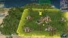
As you can see, I basically swapped the eastern Shikoku tile with the fish tile north of the rice. Let me explain my thought process.

Since we can't diagonally connect water tiles, we need to remove a tile in order to open up the inland sea. There were basically three possibilities. The first is to remove the peninsula with the tea resource. But this peninsula is a very distinctive part of Japan's geography and it would look weird without it.

This leaves the two Shikoku tiles. Removing the western one would make sense, since that would connect the other water tile 1W. In addition, Shikoku is closer to other landmasses in the east than in the west (there are bridges in the eastern part only). However, the city on the western tile, Matsuyama, is (I believe) the most historically important one on Shikoku; the copper resource is justified (Besshi mine); and the most important sea routes, I think, pass east of Shikoku, not west of it. Thus I decided to remove the eastern tile instead. It also gives the inland sea a better shape IMO.

To prevent important ports on the Sea of Japan, I put a hill tile north of the rice. It seemed appropriate to move the dye from Shikoku on the new tile, if only to discourage founding a city there. (Has anyone been able to justify the dye resource in Japan, btw?) I was worried that it would make southern Honshū too fat, but in fact the width of the island in this area is roughly the same than 1E, i.e. where the copper is, so I think the shape is actually better like this. And adding the hill correctly makes the area less flat.

Of course, Shikoku really should be two tiles, in an ideal world. But there simply isn't a way to fit it without creating a weird lake and totally screwing up the Kyoto/Osaka area. Since players will rarely put any cities on Shikoku (both tiles currently have a resource), I think the sacrifice isn't too costly.

Overall I think my suggested changes give Japan a more pleasant shape: it now looks more like the convoluted archipelago that it actually is, instead of a single smooth elongated island. And it makes the gameplay more realistic. I would be disappointed if the new map didn't allow us to correct the mistake of putting Japan's capital on the Sea of Japan.

I made a few other minor changes in the picture:
  • Made the tile north of the silver a hill, since this area (like most of Japan, really) appears to be quite hilly.
  • Added forests on the entire dorsal spine of Japan
  • Put islands in the inland sea
  • Moved the fish south to benefit Kyoto/Osaka and emphasize the Pacific at the expense of the Sea of Japan
 
Last edited:
There have been multiple suggestions for bonus varieties in this thread. I found art for some of them.

1. Alternative horses. This can be used similarly to the brown cows, same animal but with a different texture for diversity. This example has a different color for each horse, but models with just 1 of the new colors can easily be made.
@Imp. Knoedel, a MLP reskin should also be possible. :lol:

2. Cochineal, dye variety. In the post where this was suggested it was mentioned that these bugs live on the prickly pear, which this model resembles. I can change the texture with small spots to represent the insects. I can also add small nest like in this image when it is worked.

3, 4 and 5 are all suggestions for opium varieties, which maybe need a rename.
3. Coca
4. Peyote
5. Kava

6. Rare earths variety. In C2C, this model is used for platinum. I think this can also be used similarly like brown cows, same element but just a different texture for diversity.

7. Not a resource, but still related to map development. This model could be used for a hydrothermal vent NW. Examples are: Endeavour Hydrothermal Vents, Magic Mountain, 9 North and Pito Seamount. Even though the model already is a resource model, it doesn't have kfm file for animations. This is very unfortunate, because the emitted clouds (?) are the main element of these phenomena. But maybe these can be added.

8. Bison, deer variety. https://forums.civfanatics.com/resources/bowines-bison-brahmin.9620/

Are there more ideas for varieties that should be added?

Spoiler :
resources-png.548822
 

Attachments

  • Resources.png
    Resources.png
    495.6 KB · Views: 675
I support this change, here is a look at Steb's proposal in BlueMarble:
Spoiler Japan :
JP.jpg


I noticed nutmeg was added as a variant, it should be the spice on Grenada. I also think the highlighted oil should be moved closer to Venezuela as shown here.
Spoiler Grenada :
Grenada.jpg


Finally, I did a terrain run on China:
Spoiler Southern :
SC.jpg

I wanted Southern China to feel more humid. Most notably, I added two marshes in central China and converted the plains to grasslands. The highlighted tile has been changed to a hill and had a forest added, Nantong area has also been made to grassland. Various bamboo forests were added, southern china is more densely vegetated than the initial map. Some resources have also been juggled around:
Rare earths added to Taiwan, stone moved closer to Guangzhou, Fujian tea moved closer to Fuzhou/Quanzhou, silk moved to free up Wuhan

Spoiler Northern :
NC.jpg

Highlighted tile here has been made a hill, frankly when looking at a topographic map of Xian, the 1w tile should be too. Qing peninsula has been made plains as has Liaoning. These areas are dryer than the rest of mainland China. and it blends better with the steppe. Only other thing I considered is that the Yangtze River should be floodplain from the 1w Wuhan tile out to Shanghai. This area is the most densely populated in China, you could fit the populations of Germany, France Australia and Italy combined into Jiangsu, Hubei, Anhui and Shanghai. Not saying it should be directly scale-able, but it might be good to add a floodplain to represent the greater population density in this area. It isn't geographically inaccurate either.
 
Thoughts:
1. Neat, but I don't know enough how different horse fur colourings are geographically distributed to know how to use them. So additional research is needed.
2. I would emphasise the butterflies a lot more over the cacti, since they are the actual source of the dye. Unrealistic proportions are nothing new for resource graphics.
3-5. I'd have to think about that, but it's not that easy. Opium has somewhat different applications than other hallucinogenic substances. Right now I don't want to encompass them in the same resource.
6. I considered this art when originally making Rare Earths, and decided for the more unrealistic purplish hue to make it clearly distinct from silver.
8. Is the deer currently placed in North America meant to be bison?
 
1. Me neither. But it is nice knowing these are available if we know how to properly distrubute them.
2. Giant Beetles of Doom on small cacti incoming. :evil:
8. I thought there were deer in that region. I must have misremembered it then.
 
For the deer, there's some in Texas and the southern Mississippi and also some in Canada iirc. Probably meant to be native American deer.
 
I guess I should install Blue Marble at some point... Wasn't there some discussion of including it by default?
 
Yeah, I have that on my to do list.

In the meantime, it's really simple to do. You can just download that one file and put it in your Assets folder.
 
Back
Top Bottom