NES World/Regional Maps II

Status
Not open for further replies.
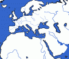
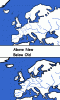
While I am inbetween NES's, I have decided to come out of retirement of map-making. Below is a sample of what I am doing to our map. I am essentially redrawing it, piece by piece. The rivers are thinner (and I have chosen only some, as I don't want to crowd the map).

EDIT: btw, in the picture below I have only done northern Europe (including Iceland and Britain), France, and Iberia.
 

Attachments

  • Sample of Redoing Map.GIF
    Sample of Redoing Map.GIF
    13.7 KB · Views: 183
I hate thin reveirs. Cause I also hate thin borders.. and with thin rivers thin borders are a must :\
 
Well... uh... Jason... I hate to say it... but I'm basically doing the same thing, minus thinned rivers. :( So is Panda. >_>

Of course he's only done Asia and Europe, and I'm doing North America, and Europe's done... so there's a lot left.
 
But it looks like you are only thinning the borders...I'm actually erasing the whole border, and making it again by scratch, section by section, so it looks more realistic.

EDIT: Another update...seems to me that the Red Sea needs to be fixed again...its hard drawing it from scratch.
 

Attachments

  • Sample2 of Redoing Map.GIF
    Sample2 of Redoing Map.GIF
    11 KB · Views: 183
Also, no offense, but Panda's is a lot more accurate...
 
*sigh* then I guess I will stop wasting my time. At least redo the rivers tho, please accurately place them (some are off) and thin them.
 
Euboea looks odd. It always does, I guess...and the Chalcidice doesn't even show up on any map I've seen. ppl!!!! :mad:
 
thats one big piece of ugly right there
 
Here's what I have:

(note that I haven't really edited in Panda's changest to their fullest)
 
Status
Not open for further replies.
Back
Top Bottom