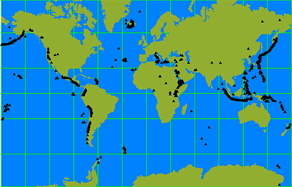
The Ultimate Map Thread

In the Layers box, you can adjust the transparency of an entire layer to any value froom 0% to 100%.

That would mean entire layer is X% transparent? What I want is for the white to be transparent so that the rest of info (names, city signs) are visible.
 
Ah, create a new layer, and set the layer's colour to 'transparency'. Then, when you draw things on it, they will appear, and if you erase them they will return to transparency.
 
Perfect, it worked like magic. Thank you! :hatsoff:
 
Spoiler Big Map :

empirewip3s.jpg


For an NES I am working on, I wanted an old timey theme. Note that the political map has none of the fluff that this geography map has on it.
 
Yeah, but too busy so I scrapped it and am just doing one entirely in photoshop- no Fractal Terrains Pro nonsense!

In the end this is what I had.

Spoiler Big Map :

EmpireWIP5.jpg

 
Spoiler :

geerios.jpg


Sorry for the double post but here is the official map I am using for the NES. Players are from the Geerios Empire and as such the capital (the red dot) would be Bozios, of course in the thread I am going to detail what those other places are as it does have some effect.
 
To be honest functionality > form. It won't matter how pretty it is if the players cannot make sense of it! Hence why I am doing a blank version just in case.
 
Well humidity/temperature/biomes is easy. All I have to to is summon up my memory of basic geography and I am good.

I have a base map down for this, I did make this in Photoshop after all meaning a poop-ton of layers.
 
Most of my biome-mapping knowledge is just what I hope is common sense, mixed with a bit of using the Coriolis effect to determine prevailing winds, and mapping in Hadley Cells. If you know better than this, I know that I'd like to hear. :)
 
Well the best place to start, really, is wikipedia if you have never taken a geography/geology (they are tied together, really, and it helps to understand the one to get better at the other) class before. No joke, wikipedia is a wealth of information on the subject and so long as your map is relatively earth-like then you can apply what is in the articles to your world. Secondly it would be best to let yourself make some mistakes- we're not perfect at all. Hell, I doubt my mountains are placed correctly so that it would simulate proper subduction, plate tectonics, etc.

Biomes, really, are the easy part once you know what causes them. Heavy rainfalls and humid temperatures will form tropical deciduous forests, normal rainfalls and normal temperatures will form temperate deciduous forests, however if we suck the rain out of that temperate area we most likely will end up with a sweeping grassland that has the occasional tree, and if we go even further it will end up as a desert. If your world is anything like earth remember that deserts normally form on the 35 degree north and south latitude (really, grab a map and look where the major deserts are and you'll notice this pattern). Mountain ranges also produce a 'rain shadow' type effect, basically meaning that a large, high range along the coast would block most percipitation from going inland, also forming a desert.

Remember long rivers generally are formed by equally high mountains (take the Amazon and the Andes for instance), either that or there are many, many, many tributaries that converge into it. Flood plains form only in arid areas normally, also heavy rainfall is needed to maintain the longest of rivers so keep those extra long ones in those humid, wet areas (for instance the Nile, Amazon, and Yangtze Rivers all flow in relatively damp places).

Ehhh, I could do more but it would help if you guys asked questions for me to answer instead of me doing a fact vomit. :P

Forgive me if I made any mistakes in this- geology is only a hobby of mine due to cartography and I am a creative writing/history major (would be geology if it were not for the fact I have to take chemistry as well! Also would be in the culinary arts if I didn't love writing and stories so much).

There are a ton of resources out there on world building. I read this great book on it that went into meticulous details that made me feel like I was back in a geology class.
 
Gimme some time then, gonna find my old textbook and world building PDF, but I have to go to class before that!
 
Ok, keeping in mind that we are talking fantasy maps here we must also keep in mind that magic can be used to explain things which would normally be downright impossible.

First and foremost is the sun. The sun is the chief source of energy on a planet, next would probably be magic if you wanted a high magic fantasy world. Solar energy is the be-all-end-all contributer to an ecosystem, and how does it do this? Simple: depending upon how the sun heats that specific surface. We must keep in mind that the sun does not heat things equally and there are great discrepencies. Of course there is geothermal energy, but that only has major effects where the sun cannot reach in full (places underground, sea floor, etc.)

So what does this mean? Well, basically depending upon the tilt of your planet it shapes the entire way seasons occur, weather is made, biomes form, and how life will thrive (or not). Earth has a tilt of roughly 23.5 when rounded up, what this means is that the earth is not a sphere that sits there with the pole going straight 'down' in space, but is always tilted somewhat away from the sun. This tilt places the equator in a position so that it always receives sunlight, while areas further north receive less light and areas south of the equator receive a little more than the north (explaining why Europe, northern North America, and Northern Asia have more temperate to cold areas when compared to the vast humid areas in southern Asia, Sub-Saharan Africa, and South America). When your are making your maps keep in mind if your planet's tilt is changed even slightly the places where deserts, jungles, temperate forests, steppes, grasslands, etc. will form is entirely different. For the sake of simplicity I will assume you guys are always using an earth-like planet that is always of the same tilt, always in a solar system composed very much like our own with your planets always the same distance away from the sun as our Earth, always at the same tilt, and always of more-or-less the same size.

Following me so far? Good! Now onto the fun stuff.

Continents are the focus of... well.. everything, but they are not just random blobs shat out onto the paper through our creative minds. Instead you should think of continents as what they really are: tips of great plates that are just floating above the world's surface.

Plate tectonics is the means through which continents move and geographical features form. As these behemoth plates move at a snail's pace they push up magma and suck in crustal material, leading to things such as mountains and volcanoes. If you are starting a map try not to go with putting down the continents -exactly-, but instead put them down in Pangaea form where they are all connected together. They do not have to be exquisitely detailed, but instead general outlines of what you want them to look like. This will give us an idea of the planet's history (as that is as important as the history your players will make) as well as give the world a 'realer' feeling as when you look at the end result you will see where the planets once connected like some great jig-saw puzzle.

Now, assign plates to these continents, look at earth's plates and its distribution of continents for a reference.

Spoiler :

earth_plates_usgs_L.jpg


Determine how these plates will move and shift, give them general directions that go one way and also try to give them directions that directly conflict with the movement of other plates. Where these two plates crash together you will have great mountain ranges and other geological features (For example the North American Plate crashing into the Pacific plate creates the rocky mountains as well as the San Andreas Fault- an area that has a poop ton of earth quakes because of the N.A. Plate constantly moving over the Pacific Plate). Move these plates along until you are happy with where they take your continents. Another thing to keep in mind is the formation of volcanoes. Where two plates meet up and push against each other mountains will rise and inside of these mountains will be magma. Now around these areas islands will form- the constant battle between the two plates is just too much for proper continents to form around them, unless a continent is formed on one side of the plate. Take for instance south east Asia which contains the Philippines, Singapore, Vietname, etc. etc. Many of the islands in this area is created by the Australian Plate, Philippine Plate, and Eurasian Plate all pushing against one another, giving rise to great volcanoes that spew forth fiery lava that cools down to form islands. Another great example would be New Zealand, and island more or less formed due to the activity of the Pacific Plate and the Australian plate (the island is formed literally on the place where the two plates meet, though it is the Pacific plate pushing west over and ontop of the Australian plate that gives rise to the landmass.

Spoiler :

volcanoes.gif


Now once you have the plates and their movements down mountains become extremely easy to make. Where ever a continent plate meets an oceanic plate the continental one will push over the oceanic one because continental plates are less dense. This is subduction and it pushes the continental plates up and out to form mountains, while it forms ocean trenches for the oceanic plates that are pushed down. Sometimes this oceanic material will melt and whatnot, make its way up in the form of magma and create volcanoes where the melted oceanic material pushes up through the mountains on the continental plate. Where two oceanic plates meet either one can be pushed down depending upon the plate's movements (the pacific plate pushing up and over the Australian plate forms the island of new zealand) and will form volcanic islands. Now where two continental plates meet both will duke it out for an extended period of time till one plate finally yields and gigantic mountains are formed. An example of this would be the Himalayas formed by the battle between the Indian Plate and the Eurasian Plate.

Mountains can also form without plate tectonics and solely with vulcanism (live long and prosper). In layman terms the slower moving magma doesn't move much between layers of rock, but the faster moving magma will force this slower moving magma up forming dome-like mountains. If the fast moving lava is fast enough it can even form volcanoes entirely independant of plate tectonics.

Forgot about islands.

Islands can be formed via volcanoes or rifting. Volcanic islands are the result of great volcanoes spewing up fiery messes that eventually cool into land. Rifting is the process of two plates moving away from each other, bringing up magma and whatnot and forming entirely new plates. These plates will drift from the 'parent' plates/continents and form islands. An example would be Greenland which once was a part of Europe, but rifted away so much that it now sits where the North American and Eurasian plate meet (or not meet, as these two plates move away from each other!)

Also think about India which once was a part of Africa, but the rifting between the Australian plate and African plate dragged that swath of land away and lead it to crash into the Eurasian plate, coincidentally forming the Himalayan mountains.

For got about archipelagoes. These are formed in areas that have high subduction zones close to continents, think of those islands in south eastern Asia. If you wanted a perticularly large archipelago have it form in an area that has a lot of subduction zones where many continental plates meet oceanic plates or oceanic plates meet more oceanic plates.

I'll refrain from triple posting and just add the biome map for Geerios here. Note that I am not following any logistics :P Geerios is an abstract of a world that I really have no idea what looks like as a whole!

Spoiler :

geeriosclimate.jpg

Light Green- Mediterrainian Forests and Woodlands
Dark Green- Temperate Deciduous Forest
Neon Green (The Islands)- Mediterrainian Grasslands
Muddy Green- Wet Tropical Deciduous Forest
Tan- Wetlands and Flooded Grasslands
Light Brown- Savanna
Green- Flood Plains
Yellow- Desert

 
You beat me! I was just about to talk about my Plate-tectonic continants map! I just finished and am starting to draw it into paint. Nice reading.
 
Biomes

Tundras

Tundras are those cold, cold regions that form either at the very top of the world near the poles, at the poles themselves, or around mountains that have extremely high altitudes.

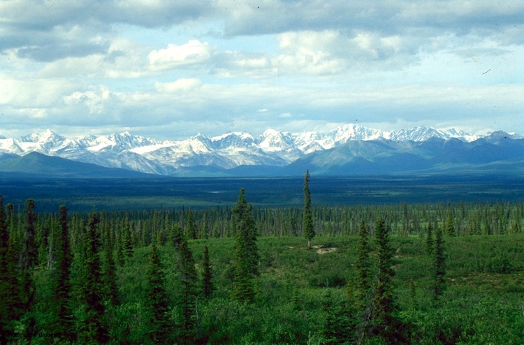
Arctic tundras most likely are the tundras most people are familiar with. Think of northern Canada and Alaska or Greenland. An arctic tundra is noted for its low percipitation and low temperatures, giving rise to relatively short growing periods. Trees are non-existent in arctic tundras and instead low plants such as mosses, shrubs, and rushes compose most of the plant life, though taller shrubs can form.

Spoiler :
ArcticTundra.jpg


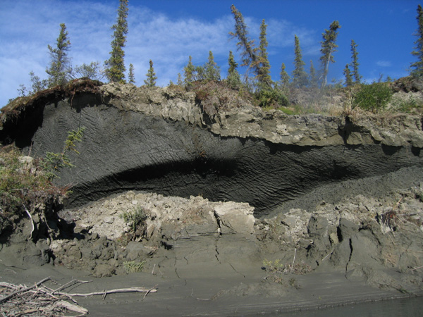
Permafrost is the driving force behind the formation of an arctic tundra as it forces all water to remain above it and will never ever thaw short of the Sun smashing into the earth or Superman using his laser eyes to burn a hole in it. By forcing the water to remain above it the permafrost leads to an environment which is relatively wet, definitely wet enough to sustain some form of life, but at the same time soil is thin and it is difficult for any large plants to take root. When seasons change and winter takes a firm hold the plant life barely remains and in areas at higher elevations the plants can be easily stripped away to reveal bare, icy rock. In areas where there is no plant life at all the seasonal changes can result in the entire landscape changing as periods of thawing and refreezing occurs.

Spoiler :
pictundra.jpg


Alpine tundra is found only at very high elevations around very tall mountain ranges and they differ greatly from an arctic tundra climate. For one they do not lend themselves to the development of thick layers of permafrost, creating a drier environment. For another they are constantly exposed to harsh winds that can easily rip plants from the ground or rob them of precious heat and energy.

This leads to plant life in alpine tundras being very short so as to not be as easily picked up by the strong winds or robbed of heat and energy. Plant life in alpine tundra are sheet-like in that they blanket the landscape and are very low to the ground and because of this curious nature the air underneath these plant-sheets can be 60°F warmer than above it.

We have to also remember that great mountain ranges can form in tropical areas and this tropical surrounding influences the nature of the alpine tundra. In the tropics an alpine tundra has more seasonal variation in rainfall, though the average seasonal temperature remains relatively the same. It is during the day and night that the temperatures fluctuate wildly: at nights it can drop below freezing while during the day you can almost swear it is summer (a tundra's summer, but summer none the less!) And because cold is not linked to seasonal changes plants have the ability to grow taller without the fear of losing much needed heat and energy. These plants are almost tree-like in nature and are able to resist the deadly cold of the night by retaining dead leaves close to their stem as a form of insulation and generally the higher you go in a tropical alpine tundra the larger these plants are.

Spoiler :
ad_22454n.jpg


As for animals in a tundra it can be said across the board that they are extremely hardy and more than able to survive such awful conditions. During the winter they are not as active, but during the summer the tundras teem with life. Insects are very common- surprisingly enough- due to the low plants isolating the ground from too much cold weather, creating an adequate microclimate!

Taiga (Boreal Forests)

Would you believe that on earth Taiga is the largest kind of vegetation? It takes up about 11% of the surface and is made up of four 'zones': the very northern tip that is not all that different from tundras, save for the fact that it has trees in the form of stunted spruces with a lot of lichen and moss in between; the belt beneath this which is more of a forest, but not quite as it still is only made up of slightly less stunted spruces, though there is less moss and lichen and more tree lifeforms; the 'main' belt that is a great big forest of pines and spruces with the occasional birch and poplar; and the last zone that is a mix of the cold-climate spruces, birches, and pines with more temperate trees found in the latitudes south of the Taiga belt.

Spoiler :
Picea_glauca_taiga.jpg


To be precise Taiga refers to the northern and barren range while Boreal Forest refers to the southern and fertile (for a really cold area) range.

Season are more grounded in taiga than in the tundra: summers are warm and moist, but short while winters are long, dry, and cold with snows lasting well into spring. Though not as extreme as a tundra, the temperature fluctuation during the winter can still be up to 200°F.

Spoiler :
PermafrostBig.jpg


Permafrost also still exists in taiga due to the thick canopy of trees keeping enough sunlight out for the thick layer of ice to form, the lack of light created by this canopy also kills off the little sheet-shrubs that are common in the tundra. Instead carpets of moss and lichen cover the ground and acts as an insulator for the permafrost, meaning that when it is colder the permafrost will move to the surface and reduce the amount of soil available and when it is warmer it recedes, though a tree's root will still be covered by the permafrost and lose water through its leaves so that they die, giving rise to the term 'winter kill'.

Wildfires are common in taiga, but unlike the danger it presents in southern biomes wildfires act as a rebirth effect in the boreal forests. The taiga trees are very resistant to fire so that during drought-periods when fires are common they will not be consumed by the flames unless it is very severe. Instead the fire will gobble up the lichen and moss carpets and create a fertile bed for new trees to be formed.

Spoiler :
pine_martin2.jpg


Speaking of gobbling up the plants animals are much more present in the taiga, though they share a bond with the tundra. Many animals, like the herds of Caribou, will exist in the tundras during the summer where they will feast to their heart's content on the low-lying shrubbery, but when fierce winter comes they retreat into the taiga forests to eat the lichen and moss carpets. The lichen feeds all manner of deer and the trees attract squirrels, birds, and beavers, who in turn attract wolves, pine martens, and lynx to name a few. Basically the taiga is still an unfriendly environment, but much more welcoming to animal life than the tundra.

Grasslands

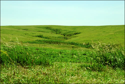
Prairie, savanna, and steppe are the three primary grasslands and the major difference between the three is temperature. Temperate climates produce steppes and prairies, while tropical climates create savannas. Prairies and savannas also share a similarity in the amount of percipitation per year which is very little- only enough to make it not a desert; savannas on the other hand receive a great deal more rain, but generally the rain comes in long periodic times during the year rather than being spaced out evenly. All three biomes have a tendency to have high rates of evaporation and droughts are far from uncommon.

Spoiler :
800px-Barabinsk_steppe.jpg


Steppes are the coldest of the three primary grasslands and their winters are cold seasons just barely above freezing. The vegetation is rather similar to a tundra's in that the plants are low to the ground, except tussok grasses ('bunch grass,' or grass that grows in little clusters rather than sheet-like) dominate the landscape.

Spoiler :
spring-creek-prairie.jpg


Prairies come in three varieties, tall grass, mixed grass, and short grass, and grow in warmer climates opposed to a steppe's cold climate. Tall grass prairies are produced by the grass being able to 'beat' the forests that could potentially grow in the area (the conditions are right for forests to be grown in areas where tall grass prairies are present) through better adaption or due to some catastrophic wildfire clearing trees from that area and leaving behind fertile soil for the grasses to take root. Still, forests tend to be near by to any tall grass prairie and given enough time the forest can overtake the grassland.

Mixed grass prairies are like the buffer zones between the short and tall grass prairies and the dominance of one grass over the other is dependent entirely upon rainfall- which definitely will vary from year to year. They contain both short and tall grasses and have no distinct grasses of their own, instead acting as a mixing ground as the name suggests.

Infrequent or otherwise light rainfall produces short grass prairies which emphasize grasses which do not penetrate deeply into the soil- as there is little moisture in the soil. Sod, or turf, is also very frequent in the short grass prairies.

Spoiler :
2.jpg


Savannas are an entirely different kind of grassland on their own due to the great amounts of rainfall they enjoy when compared to the relatively sparse percipitation in the temperate prairie and steppe. Taller grasses are common in savannas, but there are also many woodland plants growing alongside the grasses. Trees dot the landscape, but they are of generally weaker varieties that do not lead very long lives due to the high amount of competition they receive from the grasses at their base. Termites also contribute significantly to keeping the tree population low by feeding off the trees, often times creating mounds just as large as their meals!

Spoiler :
dung-beetle.jpg


Animals in general are very common in grasslands. First and foremost among them would be those animals that burrow into the ground, though they are more common to prairies and savannas due to the colder nature of the steppe. This includes the prairie dog, meerkat, armadillo, mole, and wild hamsters as well as certain species of snakes. Reptiles as a whole are also more common in grasslands than in taigas and tundras, though only found in great numbers in savannas and prairies. Grazing species are very common and are likely the animals most familiar to any person when they think of a grassland, on the heels of these grazing species would be those predators such as lions. Though of all the species it is the insect that produces the greatest effect on the grassland. As explained earlier termites stave off tree encroachment in savannas, but the decomposition of the wood and other dead vegetation eventually makes its way back into the soil to enrich it. The dung beetle, and animal that plays with poop, also spreads seeds and nutrients in its never ending smelly quest.

Next up are forests
 
Thanks Dance! I'm glad to see that my mapmaking method is reasonably realistic. However, I've got a question of one thing which I don't get.

Deltas form only in arid areas normally
The Yukon River has a huge marshy outflow where it hits the sea, as do the Rivers Fraser and Mackenzie, all of which are in the northwest corner of North America. Are those not deltas?
 
Back
Top Bottom