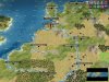
Here is worldbuilder save of the Map. I've cut out large parts of Scandinavia, South America, and Africa ... I don't think it hurts the game any (except less 'Winter War' between Soviets and Finland). Also cut off most of Australia, but I think its still enough left on to be relevant. Everything else in Europe is considerably bigger. UK and France are a bit bigger, but mainly it is Lowlands and Germany that has massively increased in size. Larger Germany and smaller chokepoint north of Denmark means building up a "Fortress Germany" can become a reality once Denmark and lowlands are captured. In the Huge Earth, there were 2 lowlands cities, in my map (which lets call the Landing Strip, because it is very long and thin) there are 6 lowlands cities (3 for netherlands and 3 for Belgium/Luxembourg).

My USA is tilted to save room (otherwise the map would have to be taller, and thus have hundreds more tiles overall, as 1 extra height = 200 extra tiles. As you can see, about 1/3 of the map is Pacific Ocean, as intended. I have considered making the Atlantic a bit wider as well, but I think it is less necessary, and also the real Pacific is much larger than the Atlantic. The widest stretch of Pacific is around 9000 miles wide, while the skinniest Atlantic segment is around 1700 miles wide. However at the latitutes relevant for this game, the Pacific is only around 40% wider ... 3500 miles from DC to Lisbon, and 5000 miles from San Fran to Tokyo.
And yet, in my eagerness to get the Pacific Ocean perfectly correct (which I did) I ended up making my Pacific Ocean 58 tiles wide (between San Fran and Tokyo), while I have only 16 tiles between closest USA shore and Lisbon, for a body of water 3.6x larger than the Atlantic ... and while its true that the Pacific as a whole is 3-5 times larger than the Atlantic, at the Tokyo latitude it is only 1.4x larger ... so to stick by that calculus I would need to make the atlantic almost 40 tiles wide (at the USA to Lisbon measurement). However to account for the shift in perspective and other considerations, a ratio of 2x or 2.4x the size would be more appropriate.
Perhaps at minimum the Atlantic Ocean should be 6 tiles wider, at 22 tiles wide (not talking about Canada to France or Canada to UK, just USA to Spain)... really anything in the range of 22 tiles to 25 tiles would be fine for our purposes. But a lot of the reasoning going into Ocean Width has more to do with Bomber Range and Naval speeds than it does to do with Earth Mapping. Still, the most accurate element in my map is the Pacific Ocean, and I tilted the USA so that I would not have to sacrifice North American Landmass in order to get the correct distances I wanted.
It all comes down to this ... the two defining combats of the war ... Soviet/German land war, and USA/Japanese naval war. If you don't get those two right, its not really a WW2 game, yeh? Also, the way I have the land set up, USA, Germany, Soviets will almost always be major powers, with Britain and Japan being significant secondary powers. Meanwhile Japan's invasion of China, and the North African campaign, are interesting events, even if they play a secondary role. In my map France wasn't made "big" enough to really threaten Germany, but it is big enough to work as a D-day level base of operations, if the Allies wanted to invade Fortress Germany of course. Many say that France fell because of its penny packet usage of tanks, or because most of its army was still manning the Marginot line, but one of the main reasons was because of a lack of Aerial coordination between the British and the French. And a lack of cooperation between the Allied Airforces and their Ground Troops .. which led to a very ineffective Ground Attack campaign on the Allied side, and an extremely effective Ground Attack campaign on the German side.
In my version there are 24 tiles of clear, open, flat land between Berlin and Moscow ... it is the "great plain" which causes so much mobile warfare in this region, and partly why Poland became so adept at mounted warfare. This corridor doesn't exist in the full/huge version, instead being replaced by a massive forest. There is however a really cool open space around Kursk (at least in the 1943 edition), but it doesn't extend all the way between Berlin and Moscow, and also you have 17 tiles between, which is quite good really, just too many forests in Poland. Technically the corridor might only extend as far as Minsk or Smolensk (from Berlin) in real life, but I did add tundra/ ice past Minsk in order to "slow down" troops (assuming a mod where snow and desert cost extra movement points without proper equipment or training). Alas, I cannot model the heavy muds of spring and fall, or the actual change in weather between mild and snow (across the whole theater of war), but establishing the open corridor itself, and covering Moscow in Snow, is a good compromise I think.
Our Middle Easts are about the same size, except I cut out most of the excess between Tibet and Iran. However, I did create an ocean corridor between Balkans and Turkey, so German units cannot simply walk into India, at least without going through Soviet Caucasus first.
I did make North Africa much more interesting however, especially to make El Alamein a chokepoint, but only one of several. Very interesting desertified terrain for Montgomery and the Desert Fox to face off within. Almost resembles the large sand dunes and desert cliffs which the generals had to navigate during the real war.
Our Chinas are also similar in size, and our USAs seem to be as well, except mine is tilted of course, and my USA is a tad smaller than my continental Europe, while your continental Europe is a bit smaller than your USA.
Your Atlantic Ocean is around 30 tiles wide using my measurement system, which is very respectable. As I've said earlier I've considered increasing mine from the meagre 16 to a more respectable 22-25, exact numbers depending on several variables.
However, your midway is not "midway" between San Francisco and Tokyo, as the real life Midway in fact IS
")
Your midway is 22 tiles from USA and 13 tiles from Japan, while my Midway is 29 tiles from the USA and 28 tiles from Japan. I also have 11 tiles between USA and Hawaii, 13 tiles between Wake and Guam, and 7 tiles between Guam and Iwo Jima. As I said, I put a lot of effort into making a Perfect Pacific Ocean

.... I created a system where Dive Bombers had 4-6 range, Fighters had 8-12 range, Tactical Bombers had 14-16 Range, and Strategic Bombers had 18+ range ... and ofc that was before you get into Jet Fighters and Jet Bombers, but I really wanted to limit the number of Jet Aircraft if I could ... once you get into the 20+ range, you can't increase much farther really, as only something like a B-50 superfortress would have the equivalent of 30 tiles unassisted range and 60 tiles ferried range (with in-flight fueling). Imho that would mean that the B-50 should stick to 30 range, with rebasing to a closer base being Civ IV equivalent of in-flight refueling imho .... drop tanks are one thing, but outside interference implies you have an airbase closer, and the only reason you are refueling is because of schedulling/logistical conflicts, which hey, don't happen in Civ IV.
Now, two things about my Map which might seem odd are American city Operation Torch, and German City Rommelbase. These are already in Africa to try and coerce the AI to sending troops into North Africa, even if only a small number of troops, to do a proper North African campaign. Granted, this design choice came about before I heard of your choice to disable airlifts, as I considered the AI might airlift units into these cities to assist in the Battle for Africa. Which reminds me, there is no Antartica in my map, or any narrow passes beneath Africa and South America, so Suez and Panama are the only way to travel between Pacific and Atlantic, making these even more critically important from a strategic level. If I am not mistaken, it was much cheaper to sail to the Suez through the Mediterranean than it was to brave the cold and sail all the way around the cape of South Africa. This isn't something well modelled in "full" maps.
My enlargening of important areas (notably Europe, Pacific Ocean, and in some ways Russia) was in attempt to get rid of "useless land" that was just going to get in the way, so that it could play more like a normal Civ IV game, and maybe the AI would be better at playing it. I snipped away at extraneous land the same way a good director or editor snips away at the elements of a Story that don't move the plot forward. A good example would be Star Wars A New Hope vs Star Wars Phantom Menace. In the latter (and especially the George Lucas version of Clone Wars before the cartoons made it good) there were so many extra scenes which did nothing to the plot, so too might extra lands and peoples confuse the AI from the real central narrative, the important battles etcetera.
It is partly this reason why I do hesistate in adding those 6-8 extra tiles of width to the Atlantic Ocean, because due to Operation Torch and D-Day, and of course the American "Europe First" policy, it might not be terrible to keep USA fairly close to Europe, so that an AI player might be tempted to follow a similar path. Truly, the Pacific Ocean is incredibly important due to the Island Hopping strategies, and the abilities for certain planes to take place in certain battles and for others not to, and for Carriers to actually mean something in a reality where carrier planes are more specialized to take on Ships than actual land positions ... In any case what I mean is that the Pacific Ocean matters in terms of Air and Sea warfare ... while the Atlantic Ocean is only there to prevent New York bombs from reaching Paris ... without going through London first of course.
And similar effects could happen from just making maps more massive and even more massive .... but A) you would just be reintroducing more 'useless' areas, and B) you would make the game all but unplayable except on God Machines specifically designed to squeeze as much performance out of BtS Civ IV as is physically possible
")
.... essentially we still want the game playable on a variety of machines ... and therefore a smaller and more focused map, where the important areas are actually bigger .... does seem to be a winning solution.
I do hope you take a look at my map with serious interest, and please give me back plenty of feedback!!! As a fellow creator, it heartens me that you have adopted many of the design choices that I have considered for a WW2 mod (as I was trying to recreate the long lost 1939 mod but with a new religions-using flair) ... including using an early version of Pz IV and a late game version of Pz IV ... and that the unitgraphics are so accurate! It is truly a dream, and I hope that my map could be of some use, even if only as inspiration for an even better map. But of course, if you wish to use my map, or some variation of my map, for a scenario, feel free! As I am quite busy most of the time, sadly it may be some time before my map sees a place in a scenario of my own design.
Anyways, thank you for the quick response. Merry Christmas and Happy New Years!
 . Late game turns take longer a you might get up to a point where it crashes