Neverwonagame3
Self-Styled Intellectual
- Joined
- Sep 5, 2006
- Messages
- 3,549
Assuming the implication is as would seem immediately apparent, I'm content with the information already there. But the other potential players might not agree.
Are starting locations limited to the economic zones, or are they simply the suggested "best" areas for development of a society?
I would like to see more information on each of the zones, especially when it comes to the sort of agricultural activities they pursue.
Crops: Lengmang, Engang and Lencang.

Population density is low and is organized by direct familial ties, does not form settlements larger than a couple of dozen;
")
I would like to see more information on each of the zones, especially when it comes to the sort of agricultural activities they pursue.
Das said:Or are they from words from different languages within the linguistic traditions and placed deliberately with the descriptions of different traditions? The former makes much more sense, but you never know.
Das said:Chinese pronunciation or otherwise?
Das said:Lastly, we'll probably need names for the language groups as well.
Das said:Couple of dozen people, households or families?
Das said:Incidentally, I assume you also have at least some general ideas for the rest of the world, even if it won't really come into play for the first hundred turns or so.
Das said:Seconded, though I understand that this was already promised earlier.
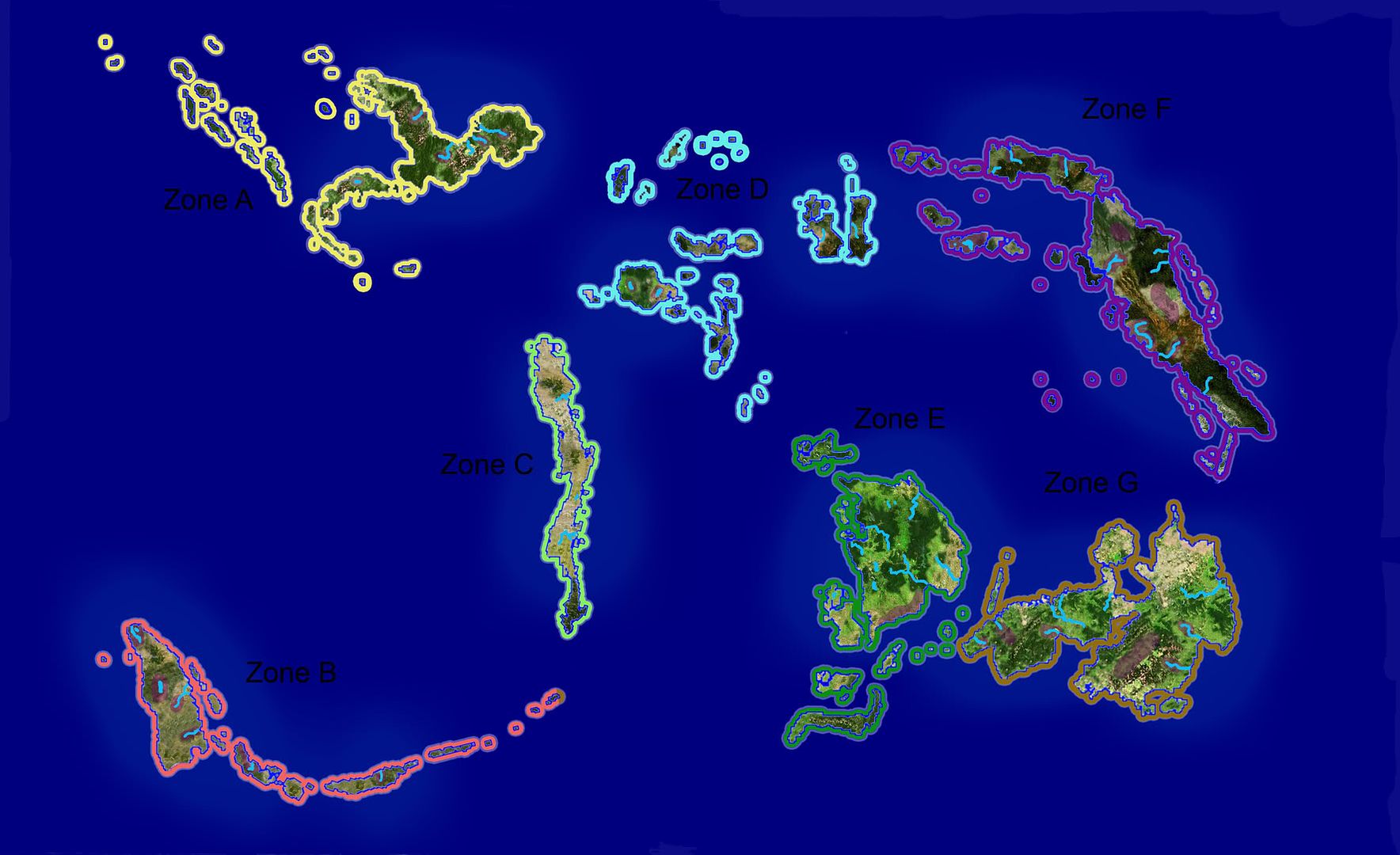
OUTER ZONES:
Zone A:
Economic Structure:
No knowledge of rice farming.
Millet is ill-suited to the rich alluvial floodplains, due to endemic ‘root rot’ bought on by persistent moisture.
Taro and Yams are the major crop of choice, cultivated in artificial crude terraces cut into hills.
No knowledge of rice farming.
First traps are used to fatten up fish, they are created by artificially blocking numerous small tributaries.
Large stands of bananas, sago palms and coconuts are maintained.
Social Structure:
Population density is low and is organized by direct familial ties.
Settlements are typically no larger than a dozen individuals.
Population is largely concentrated near rivers, due to substantial semi-tropical forests.
A degree of social stratification is evident, with ‘High Chiefs’ able to call together a small number of extended familial units for limited warfare.
Has only recently been settled in living memory, large portions of the interior are not inhabited.
Climate and Geography:
Semi tropical, with high mountains, very hilly, numerous valleys, numerous minor tributaries feeding into deep river valleys, extensive very deep semi-tropical forests which cover the majority of the landmasses, unusual wildlife, rich soil in the river valleys and hills.
Economic Zones:
Zones all broadly similar to the summary.
Zone B:
Economic Structure:
Knowledge of rice farming.
Millet is the principle crop, which is well suited to the relatively dry conditions on almost the entirety of the chain.
Due to dry conditions and poor soil in a large part of the chain, population density tends to be high.
Taro and yams are major crops, which are also well suited to the drier conditions.
Small stands of bananas and coconuts are maintained, with great care.
Taro and Yams are the major crop of choice, cultivated in artificial crude terraces cut into hills.
No knowledge of rice farming.
Social Structure:
Groups are not organized solely on direct familial links but on purported ancestral links allowing for larger aggregations of population.
Indecisive warfare between rival ancestral units is common and endemic.
A high degree of social stratification and organization allows for significant mobilizations of the male population in times of strife.
Social stratification is evidenced by the ability of ‘High Chiefs’ to pull together ancestral units in times of strife, increasingly they are beginning to exercise tangible power in the day to day management of these units.
Climate and Geography:
Dry, semi-tropical, hilly, many dormant volcanoes, poor forests, rivers slow with flow dropping during the driest part of the year, rich soil due to the resulting mud used to enrich the fields.
Economic Zones:
Zones all broadly similar to the summary.
Exception is existent for the sole lake zone, rice farming is practiced in the numerous very shallow areas of the lake proper. Successive generations have increased the size of this extremely fertile zone.
Zone C:
Economic Structure:
Knowledge of rice farming.
Low dependence on settled agriculture due to sandy soil and a dry climate.
Stands of bananas, coconuts and sago are still maintained, often in stands placed strategically along the coast.
Fishing by far the largest source of sustenance.
Social Structure
Population density largely concentrated on the coast and is low.
Familial units are ‘boatloads’ owing to the extensive maritime focus and the dependence on the sea.
Chiefs are appointed or inherit the position in charge of ‘boatloads’ depending on the dominant custom in the region.
Chiefs often work together with other chiefs, little scope for warfare.
Population spends much of its time on the sea, children are taught to swim before being to walk.
Climate and Geography:
Dry, tropical, largely flat, two active volcanoes, few and poor forests, rivers slow with flow dropping during the driest part of the year, poor sandy soil with high salt content not conducive to farming.
Economic Zones:
None.
Zone D:
Economic Structure:
Knowledge of rice farming.
Rice is becoming the principle crop, which is well suited to the wet conditions on almost the entirety of the chain.
Millet steadily being phased out in favour of more efficient Rice.
Stands of bananas, coconuts and sago are still maintained often in vast plantations.
Fishing is a significant source of food.
Social Structure
Population density largely concentrated in the highlands, with a small but growing minority moving towards the coast.
Population is still largely transient, although the trend is towards sedentary coastal living.
There is a sharp divide between the smallest islands which are orientated to the sea and the larger islands which are agriculturally orientated.
Social stratification is almost non existent, although ‘big men’ are increasingly ending up in control of the small groups.
Climate and Geography:
Wet, tropical, island centres dominated by mountains and hills, a small flat zone on the coast is common to most islands, very dense forests, occasional areas of little plant life, rich volcanic soil.
Economic Zones:
The economic zones are populated by sedentary wet and dry rice and millet farmers. The Lake shore and surrounding area are very fertile.
That one
Settlements are typically no larger than a dozen individuals.
Population is largely concentrated near rivers, due to substantial semi-tropical forests.
So, uh, the former or the latter?
For the sake of convenience you could also add the distributions of the three language groups in those zones, seeing as this is what people will look at before beginning to create their cultures.
Might be good to add the sparsity/density of settlement (i.e. both proximity of settlements and their quantity) to complete the picture, as the population of the valleys can still deviate wildly within what parameters you did set ("how many settlements of dozen people?").
Also, related to this, can you rate the different zones according to their current population?
As to "boatload", how many people is that supposed to be, on the average? And you have only mentioned it for one zone so far - wasn't this terminology implied to be more universal than that?
The later.
)I'm still thinking about how to do this...
I can do that, would a simple list of which is the most populated to the least populated be sufficient?
A boatload varies between 25-100 people, depending on the region, those of the West would be closer to the upper bound (longer journeys and all that), while those in the East would be closer to the lower bound (short inter-island hops).
Then how about giving the equivalents in the other language traditions, for the sake of comparison?
(Or are we still talking about different formers and latters? )
Settlements per square kilometers (or square li, or whatever). Alternatively, just say that the settlements are sparse or on the contrary that there are dense concentrations of settlements in the river valleys.
That's what I had in mind, yes.
So you have settlements that are 1/8th of a boatload (in the west, if I am not mistaken)? That seems a bit strange, unless there are some further subdivisions ("canoeload?" "raftload"?).
How large a geographical area does a player's starting 'people/civilization/group' cover?
How large a population does a starting player's people encompass?
If you start as a sedentary farming group, do you start as several groups or one? etc.
. I will however allow players to give me an outline of what it is they ideally want at the end.
- a clear objective;
- some precedent or an antecedent for changes;
- a 'hook' that is a means of gathering support, popular or otherwise for the reform;
- some description of the functionality of the institution; and
- some likely consequences in terms of social and economic changes.
- legal institutions, including how land and possessions are inherited and how property is held [max cost 1 level 1 point];
- political institutions, including hypothetical models of government (some might not be appropriate first turn) and how government functions [max cost 1 level 1 point];
- economic structure, including who holds land, how land is worked and whatever else you want to come up with [max cost 1 level 1 point].
