[Development] Alternative Map during 1.17

I made the tree less dense by removing many trees. (I think it has 20-30 fewer trees) I also move the bamboo stalks a bit, so they do not hide behind the trees.

I didn't touch the colors yet.
Maybe it's just due to the color scheme, but I think I'd have a really hard time distinguishing bamboo from regular forests in the game, especially if it's on a grassland tile where the bamboo seems to fade into the grass.

@Leoreth, is there a reason you want bamboo to have the stalks interspersed with regular trees. I was thinking more like a classical 'bamboo forest' (see any of the photos in the Wikipedia article here), with bamboo stalks growing very close to each other, with slight foliage on their tops, but few if any other types of trees.

The bamboo and regular forests could intersperse if the two tile features were next to each other, but I don't know if there are that many 'mixed' forests to begin with, let alone how representative a mixed forest would be.
 
I don't think it is that important that they are not that distinguishable, I only intend to use it as a graphical variant for the forest feature.

I want it to be a mixed forest because at the scale of the map, it is simply not reasonable to say that an entire tile is covered just with bamboo.
 
I want it to be a mixed forest because at the scale of the map, it is simply not reasonable to say that an entire tile is covered just with bamboo.
That makes sense. @merijn_v1, would it be possible to increase how much the bamboo 'clumps'? In your image, I see one or two bamboo patches with several stalks together, but many more that are simply individual stalks. Even if each clump were just 3-5 bamboo together, it's go a long way to making the feature more visually distinct and more realistic.
 
That makes sense. @merijn_v1, would it be possible to increase how much the bamboo 'clumps'? In your image, I see one or two bamboo patches with several stalks together, but many more that are simply individual stalks. Even if each clump were just 3-5 bamboo together, it's go a long way to making the feature more visually distinct and more realistic.

Good suggestion. I think that would looks more realistic and it would help distinct the varieties.

I think it would be nice if there is another forest variety: a mix of the leafy and evergreen variety. It can be used for mixed forest and for a smoother transition between decidouos and evergreen forests. As these mixed forest generally have the leafy variant dominating, I think a 70-30 ratio would be nice.
 
Last edited:
Oh it would be really cool if the terrain art reflected the changing seasons once you drop below one year per turn. But the game isn't really built for that.
 
I thought actually that that would be nice to see every so many turns. I wouldn't mind to have summer trees in 1350 AD and then autumn trees in 1400 AD. It's just like "oh well, I jumped some time in history and this year I happened to land right on the autumn season." Alternatively, having some forest spots be permanently in autumn would be fine, it's just for coloring and nice looks :)
 
Oh it would be really cool if the terrain art reflected the changing seasons once you drop below one year per turn. But the game isn't really built for that.

It would work similarly to the winter mechanic in The Road to War mod. It shouldn't be that hard to include.
 
Is it also an idea to consider these transitions?
Tundra: completely white / the gray covering we currently have (all snowed in winter)
Green forests / autumn foliage (as discussed)
Snowy conifers / green conifers (we have both art types; not for all the conifer forests in the game, but just as a transition between permanent snow farther north and permanent green south)
in the tropics: darker green / yellower green (slight variations, to show rain and dry seasons)
Flood plains: extended flooded area (the browny patch next to the river) / narrower or absent flooded area (also for dry and rainy seasons)
 
It would work similarly to the winter mechanic in The Road to War mod. It shouldn't be that hard to include.
There are still problems with that, seasonanility does not just influence tree leaves but overall vegetation peaks and water availability etc. not really stuff the game is equipped to represent, nor should it.
 
I made a new version with larger clumps of bamboo. Left is the new version with larger clumps, right is the old version. In the middle is a stroke of regular leafy forest.

Spoiler :


There is not a huge difference between both. (Maybe it will if the bamboo has a more distinct color. However, there is a small problem with the large clump version. When you zoom in, there are some rendering issues. I have no idea what caused it and if I can fix it.

EDIT:
I forgot to add some nif property. It works properly now.

Spoiler :
 

Attachments

  • Civ4ScreenShot0205.JPG
    Civ4ScreenShot0205.JPG
    579 KB · Views: 1,051
  • Civ4ScreenShot0206.JPG
    Civ4ScreenShot0206.JPG
    572.8 KB · Views: 1,018
Last edited:
I was thinking that one solution to having an accurate, snaky, island chain looking Japan was to provide a bonus on islands. I haven’t played with the variables but either a civ ability or a unique building ability that gives Japan extra hammers, gold or food on worked island tiles. This would allow for an accurate looking, but no less effective Japan. The other cool thing is it would incentivize Japan to colonize the South Pacific islands in the late game.
I'm certainly not in favor of making it even bigger, perhaps the original is the best blend of scale and effectiveness if my island idea causes issues with game play.

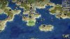
Anyhow, today I took a shot at some areas in the Mediterranean.
Spoiler Greece :
greece.jpg

Only tile change is highlighted, the addition of Sparta. Upon looking at a map I took issue with having Sicily extend further down than Greece. Both southern tips reach about the same line so it didn't make sense to have Italy running so much further down. now, upon making changes I noticed that Anatolia's position should actually sit further south as well but this would create all sorts of problems with scaling. I drew this red line to show that by adding one tile to Greece accurately represents its shape while also fitting the contour of the map. My only other change was adding copper to Greece, I find that too often Rome builds the Colossus and while Rhodes isn't possible, I'd like to see more of it in Greece. The production resource also helps with Greek units, wonders and ships.

Spoiler Israel :
Israel.jpg

Try not to mind the sea gashes, I didn't take the time to reload. First of all, I'm not suggesting that the Nile delta should be condensed, I merely made this change to see how it would look. I'm not sure one way or another quite yet. Next is the change to Cyprus. I just don't feel its a big enough island to merit two tiles, It's about the same size as Crete but quite a bit chunkier. The shape from before essentially meant that one tile represented the western portion of the island while the upper tile to the east represented the very thin jutting peninsula.
Next, Aleppo. Very important city historically, while it doesn't need to be on the map, I removed the dye so that it might be placed. I don't know enough about Levant resources to place it so I'll leave that to others. I also moved the olives from 2s to 1s so that there would be room for Damascus.
Damascus is another city that was very important historically but it lacks production in this map--actually, this whole region has always played a big role through various chapters in history. "Damascus Steel" is not actually from there but was named after the city for its historical role as a swordsmithing city. Therefore, iron 1s and sheep moved to 1sw.
Next, Acre and Tyr. Now Akko, this was a city that was important for a number of empires. It crowds the more important Damascus and Jerusalem so I don't see it being settled very often. Tyr is the starting city for Phoenicia. I'm not sure if there's a way to script its destruction in favor of Damascus in the medieval era. Otherwise Tyr and Damascus will vary from the 3000BC or 600AD.
Finally Jerusalem. I suppose it could also be placed 1s. Israel has a very rocky terrain and is rich in stone so I have added stone as an additional production resource. Salt and citrus are both accurate, wheat could also be added if we want an additional food resource.

Spoiler Tunesia :
Tunesia.png
biome.jpg

I don't know much about resources for this region, these all seem about right based upon city and empire needs. I cross referenced a couple of biome maps and the mix of desert and Mediterranean plains was about right everywhere but here. Its worth noting that the biome map I've attached is not gospel, its just one example. I looked at a handful before making changes. I've added a band of semi-desert. Now you might notice that Iraq is also classified as semi-desert so I played around with it a bit and found that the full desert with floodplains seems to look aesthetically better. In the case of north Africa, the semi desert looks better as a nice transition. Only problem is now the wheat looks a bit weird.
 

Attachments

  • greece.jpg
    greece.jpg
    1,012.2 KB · Views: 289
I think both Tyre and Damascus should be 1SW, and Jerusalem 1S. Also, an alternative to Aleppo is Antioch 1W.
 
I think both Tyre and Damascus should be 1SW, and Jerusalem 1S. Also, an alternative to Aleppo is Antioch 1W.
I second this, furthermore Aleppo is supposed to be 1W, being clearly west of the Euphrates. Acre would go 1S as well. Finally, the red flower resource (Opium if I remember correctly) should be moved, as that tile should be the canonical placement for Nineveh/Mosul.
 
Oh, I thought that was 1E, at least that would be less crowding with a Syrian city.
 
I second moving the Opium. I think the marked Aleppo tile in the post is already fine, though; Antioch was also important especially in the Roman and Crusades eras, so it should be the one 1W. Then there'd be a choice of either Antioch or Aleppo.
 
Top Bottom