An Atlas of Rhye's World

It's done in OmniGraffle on my ageing PowerBook. It's just split into layers so I just hide all but one and export to a PNG to produce the overlay. (Does the final product work okay on someone else's computer? It seems to work in Firefox and recent versions of Safari.)

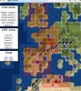
You're correct, I have missed off Carthigian areas around Tyre ; thanks, I'll fix that. The symbols might actually be useful for something...

I remain particularly concerned that I'm getting the UHV areas wrong though.
 
This is great info.

IIRC, the island of Sardinia on Italy's West coast is within Roman control, I had a city there that flipped to Rome in my last game. Are areas fixed, or do other factors than plot locale effect which locations flip?
 
Sur doesn't seem to flip to Qarthadashtim in my games. Does anyone know if there's a particular reason for this?
 
how about the Spannish UHV area. Are the lands that the Spannish seek to conquered in America made smaller? Are they just the core lands of the aztecs and the Inca so they will try to invade?
 
Thanks, I'll try to fix that.

America-related UHVs, I'm not that bothered about. If someone else wants to draw up the squares, I'd be happy to include them. Might do it if only for the English UHV.
 
Mongolia should be fixed but I'm not in a much better state of mind then the last attempt ; it looks a lot more sensible now. Rest okay?
 
Zetetic,

I like what you have done with the map.

However I played as the romans and had cities (all below 5 in pop) in the correct areas in the year 450 AD but still missed 1 of the 2 goals at that time point.

Could the roman UHV area be wrong?
 

Attachments

  • map.JPG
    map.JPG
    90.7 KB · Views: 444
First answer: In the latest patch? I only ask because the Carthage area only includes your eastern-most African city in the latest version.

Second answer:
Code:
bSpain = self.checkOwnedArea(iRome, tCoreAreasTL[iSpain], tCoreAreasBR[iSpain], 2)
bFrance = self.checkOwnedArea(iRome, tCoreAreasTL[iFrance], tCoreAreasBR[iFrance], 3)
bEngland = self.checkOwnedArea(iRome, tCoreAreasTL[iEngland], tCoreAreasBR[iEngland], 1)
bCarthage = self.checkOwnedArea(iRome, tCarthageTL, tCarthageBR, 2)
Hmm, I have got the 'Carthage' area wrong but if anything it's bigger and contains the real area of Carthage's core and so should contain those cities anyway. I'll have another look through to see what I've done wrong.

As always, I welcome someone more awake, competent and coherent than myself to draw me where the damn areas are. I don't particularly believe many of them are actually really correct (but the Russian and French ones turned out to be useful to me).

I'd also like to do a couple of resource overlays maybe. If anyone can give me pretty symbols for oil and dyes (Civ 3-style maybe, but decent quality ; the resizing seems to cause enough problems with aliasing etc. under Windows as it is. Why can't all browsers under all systems resize intelligently? I swear that in Windows, Firefox just drops information instead of trying to interpolate...)

Oooh! (This post is being edited quite a bit which partly explains its dyspraxic nature.) I see you're using IE7. It's nice to know it works in it.
 
Zetetic,

Thanks, I might play around in world editor to see where the carthage cities need to be to get the Roman UHV.

Yeah it is IE7, just got it recently. Actually your overlays on the map did not work for my old IE before I got the new IE7.
 
These maps are GREAT utilities. Keep up the good work!
 
Version which I think is better and kinda supports adding overlays from your own computer (Local in the bar at the top), here. Any feedback, fixes, additional overlays are welcome.
 
Beijing is Mongolian??? :eek:

@ Zetetic Apparat.

Whew. That looks better. It's really cool too. BTW, is there any chance of getting the UHV areas for the Incas and Aztecs as well? I'm particularly interested in which islands are part of what.
 
Back
Top Bottom