rock_and_ride
Chieftain
- Joined
- Sep 20, 2009
- Messages
- 74
so, a few weeks ago i asked about if there is a chance to get true location names on the earth maps. as i said, i am not able to code this into the mod. sadly, i completely lack the skills for this. however, i would volunteer to provide data mapping so someone could code it in. also, i might be able to code it myself once the SDK is released and i can make sense of it, but i wouldn't count on this 
now i made a test balloon of the data mapping. here is what i made in a few hours for the Play Europe Again map. the data is limited to the british island as well as ireland and island. the mapping is added as .csv if it helps anybody to experiment with it.
if you want some deeper insights in what i took into consideration to choose a specific name for a specific tile, you can read the following spoiler content.
i was driven mostly by the landscape and the city size. my approach was for example that tiles along rivers should hold cities that are also on that river in real world. furthermore rivers divide city names except when the city is defiently on both sides of a river. for example: london is several tiles north and south along the thames river. however, if you move your settler to the cliffs of dover, you WILL get dover there! if you move more inlands along the thames you will found reading or oxford (depends on the exact tile). also if a city is clearly more on one side of a river, say west of it, then the east tile of this river might have a different city name, one that might even be more inlands east to that river. take cardiff for example: you will found this city if its west of the bristol canal and you will found bristol if its east of the canal. see the links to the screenshots down this post.
coast lines are very significant and end up in a lot of city names sometimes of smaller cities. so if you found a city on a coast where there is a bigger city nearby in real world, but this city is most likely not to be on the coast, you will not get the bigger city but the smaller city name. this is a point i actually want to discuss with the community, if this is going to be a real project some day.
furthermore i take hill and especially mountain adjacency into consideration.
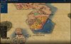
after mapping it to a file, i tested it on the map by manually renaming the cities. that way, i simulated a yet-to-be-done implenetation. here are two different type of "placements" i did on the map, one with the priority to found as many citites as possible and the second with some basic "most likely the best place for a city" in mind. i rushed through both examples however, so don't nail me down on the placements. its just so you can get a feeling of how it could be. as already mentioned, i used the Play Europe Again map and also set the Ruleset "Euro 2: Medium" which changes min distance between cities to 2 instead of 3.
these three screenshots are with priority "as may cities as possible": http://imgur.com/a/horCk
these three screenshots are with priority "probably good spots in a real game": http://imgur.com/a/3PBzr
this is how you might end up playing as england if you would play with the "true location city names" option as well as the ruleset for having only 2 min distance for cities.
now, with this "test balloon" pumped up so far, i would like to ask if this is something that would be interesting to get hands on as a real project. as i said, i CAN NOT code it! for the time being, all i can is to provide the data mapping. the format would need to be specified (csv, xml...?).
my very first questions are:
1) is this feature something the community would like to have?
2) is there anybody out there who can test this idea further and trying to code it into the map?
3) did i miss something?
4) so how do you actually correctly pronounce Birmingham?
now i made a test balloon of the data mapping. here is what i made in a few hours for the Play Europe Again map. the data is limited to the british island as well as ireland and island. the mapping is added as .csv if it helps anybody to experiment with it.
if you want some deeper insights in what i took into consideration to choose a specific name for a specific tile, you can read the following spoiler content.
Spoiler :
i was driven mostly by the landscape and the city size. my approach was for example that tiles along rivers should hold cities that are also on that river in real world. furthermore rivers divide city names except when the city is defiently on both sides of a river. for example: london is several tiles north and south along the thames river. however, if you move your settler to the cliffs of dover, you WILL get dover there! if you move more inlands along the thames you will found reading or oxford (depends on the exact tile). also if a city is clearly more on one side of a river, say west of it, then the east tile of this river might have a different city name, one that might even be more inlands east to that river. take cardiff for example: you will found this city if its west of the bristol canal and you will found bristol if its east of the canal. see the links to the screenshots down this post.
coast lines are very significant and end up in a lot of city names sometimes of smaller cities. so if you found a city on a coast where there is a bigger city nearby in real world, but this city is most likely not to be on the coast, you will not get the bigger city but the smaller city name. this is a point i actually want to discuss with the community, if this is going to be a real project some day.
furthermore i take hill and especially mountain adjacency into consideration.
after mapping it to a file, i tested it on the map by manually renaming the cities. that way, i simulated a yet-to-be-done implenetation. here are two different type of "placements" i did on the map, one with the priority to found as many citites as possible and the second with some basic "most likely the best place for a city" in mind. i rushed through both examples however, so don't nail me down on the placements. its just so you can get a feeling of how it could be. as already mentioned, i used the Play Europe Again map and also set the Ruleset "Euro 2: Medium" which changes min distance between cities to 2 instead of 3.
these three screenshots are with priority "as may cities as possible": http://imgur.com/a/horCk
these three screenshots are with priority "probably good spots in a real game": http://imgur.com/a/3PBzr
this is how you might end up playing as england if you would play with the "true location city names" option as well as the ruleset for having only 2 min distance for cities.
now, with this "test balloon" pumped up so far, i would like to ask if this is something that would be interesting to get hands on as a real project. as i said, i CAN NOT code it! for the time being, all i can is to provide the data mapping. the format would need to be specified (csv, xml...?).
my very first questions are:
1) is this feature something the community would like to have?
2) is there anybody out there who can test this idea further and trying to code it into the map?
3) did i miss something?
4) so how do you actually correctly pronounce Birmingham?
")
")
 ). however, the map is pretty small for 2-range names to be effective. you end up adjacent to a river that is totally NOT where the real city is even close to. also, there is a question about naming behavior because with the Ruleset: Medium, you can build cities 2 tiles away instead of three. but that way, you can build 2 cities in a 2-range name! one complete to the left, one complete to the right. both cities would now have the same name if there is nothing else that is overlapping them. btw, i refer to ranges as 0-range, 1-range and 2-range meaning that 0-range is a tile that does not spread its name to adjacient tiles. so only if you settle on this tile you will get this name. however, the same name may be given to several 0-range tiles. this is mostly useful for getting the right city names on the right sides of rivers, as well as placing coastal name tiles as there are often only 2 tiles for a costal city.
