Altered Maps ': To make a map larger than what it maps.

At least this time we have an authentic Greek person using Greek numerals. :)
 
I'll use this thread to ask for your opinion:

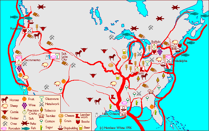
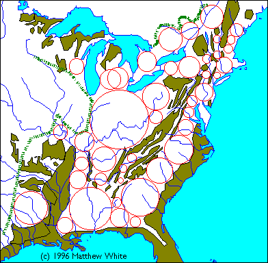
what are these images showing?


It's from the Medieval America site. The author is (was) trying to make a 'believable' world in which technology regressed back to the Middle Ages and America is a mish-mash of feudal kingdoms, nomadic steppe tribals, and absolutist hydraulic empires.

This clearly is some geometric way of determining where nations/kingdoms would form, but how does it work? In the first picture, we have Europe and the same methodology is obviously applied in the second map. This would explain his other map:

Spoiler :


So, any ideas?
 
The euro map seems to be based (?) on mountain-ranges? (at least the outline of the old AH empire and some other stuff in Greece and half of Bulgaria seem to echoe that, along with the more obvious Alps).
Not sure why no "kingdom" would exist east of Austria and Bosnia, below the north ;)
 
That Europe map looks like it's showing mountain ranges

The euro map seems to be based (?) on mountain-ranges? (at least the outline of the old AH empire and some other stuff in Greece and half of Bulgaria seem to echoe that, along with the more obvious Alps).
Not sure why no "kingdom" would exist east of Austria and Bosnia, below the north ;)

Mountain ranges, swamps and other 'uninhabitable' (=not good for the kind of forest zone agriculture practised in feudal Europe) areas.

I believe this is some sort of model predicting where bigger feudal states will pop up. The dashed green line obviously show the limits of the steppe, from where nomadic invaders disrupt agricultural societies, and the taiga, where agriculture is impossible. That same model is then applied to America, or rather its temperate forest zone part.

I wonder, is it about drawing the largest possible circles which don't touch the coast or the 'uninhabitable' terrain? And maybe it's not as much states as 'nations' in the ethnic sense. After all, Germany isn't exactly a model of political unity (but medieval states rarely were), but it maintained a great deal of cultural unity.

I have no idea why England has two circles.

Is there any way to find out on which web page an image the URL of which is known was used?
 
gold areas seem to be areas that are not conducive to permanent middle age settlements. much of the atlantic coastline is swamps or marshes and appalachia is too mountainous.

it could be that the gold areas are areas with bad agriculture...
 
I didn't know what other thread to put this in... Click on link, then click on the double arrows for some altered google mapping. I usually don't have anything nice to say about Google, but this is a nice little gem.

Hi! Click me, I am your friendly link!
 
Oh, my, bleeping, DOCTOR.
 
Kyriakos I think today its your non-birthday…
I made you a map


As for the american map, golden areas is written to have less than 1 million people there..
 
Megali Elliniki Autokratoria!
 
You left out the blank maps!


Spoiler Maps, maps, maps :


Spoiler Larger version of the above (MUCH LARGER) :

More blank maps HERE or here.
 
Kyriakos I think today its your non-birthday…
I made you a map


As for the american map, golden areas is written to have less than 1 million people there..

The resistance isn't futile, they have the best start in the entire world. Only a single port.
 
Where does the Madagascar meme originate from? I thought it was purely a CFC thing, but it is widespread. And yeah, I know which game it is from, I am just wondering who came up with the meme itself.
 
Pandemic 2, a flash game where you infect the world with a virus....but Madagascar always holds out, as soon as someone coughs in Brasil....CLOSE....ALL...PORTS
 
Pandemic 2, a flash game where you infect the world with a virus....but Madagascar always holds out, as soon as someone coughs in Brasil....CLOSE....ALL...PORTS

As I wrote above, I KNOW it's from the game. I want to know who said it first.

I used to think it was purely a CFC meme, but then I saw a video on youtube where there was a map of the world, and a message "CLOSE... DOWN... EVERYTHING!!!" showed next to Madagascar. So clearly it is known outside CFC.
 
Supposing the virus would not get released at many places in pretty much critically the same time, one would suppose that areas like that Danish colony (Greenland ;) ) would more easily be sealed off?
 
Top Bottom