United States of Canada vs Jesusland, 2008:
<snip>
I don't get this map... What is it?
United States of Canada vs Jesusland, 2008:
<snip>
I don't get this map... What is it?
It first came about after the 2004 election, base on the idea that the North East and West Coast were far more politically similar to Canada than the rest of the US (not particularily true, but that is the basis). At that time it created to contiguous entities (except Alaska). The 2004 one is below.I don't get this map... What is it?
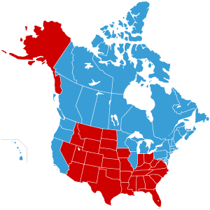
I think I see such maps every now and then. Wouldn't know where to find them, of course.Even doing it by county isn't all that useful.
What I would like to see is a 2008 map that not only breaks down by county, but colors each county a shade of purple based on the percentage it went for one or the other, rather than strictly blue/red.


some US states, particulary in the west, is devoid of any natural borders. it looks ugly... if a state bordered on the colorado river, that would look much better.
Victoria II Great Powers (dark blue) and Secondary Powers (lighter blue) based on GDP (PPP) rankings.
snip

That's a damn good list, actually.Victoria II Great Powers (dark blue) and Secondary Powers (lighter blue) based on GDP (PPP) rankings.
Spoiler inserted by Dachs :
Now I'm tempted to do civ/unciv.Victoria II Great Powers (dark blue) and Secondary Powers (lighter blue) based on GDP (PPP) rankings.

")
Not prestige, military and industry?
Now I'm tempted to do civ/unciv.
and now for something completely different...
and now for something completely different
That's because the Western US was mostly empty when it was divided into territories. Dividing things along natural boundaries doesn't make sense when there aren't enough people (or should I say, "people," since there were plenty of Native Americans) to make any of these boundaries meaningful. Which river is more important? Do we make rivers the borders, or mountain ranges? Or do we perhaps work on the basis of drainage basins (that's how the D.R. Congo got its ridiculous shape)? In Europe, one has ethnolinguistic stuff to guide decisions on which geographical features are important. In 19th-century America, the geographers and surveyors had no such guidance. So they just used straight lines as much as possible, using major rivers (like the Mississippi and Missouri Valley states) and mountain ranges (as in the Idaho/Montana border and the Arizona/California border) where convenient. Since the Land Ordinance of 1785 was such a success, the US was divided into square-shaped townships and plots.
And Canada, which faced the same problem, isn't much better. Saskatchewan is a perfect section of the Earth's surface, defined exclusively by two circles of latitude and two meridians of longitude. It's no accident that most quadripoints are in the Americas, and that both of the rectilinear quadripoints are in North America: the Four Corners in the United States, and the one between Nunavut, the Northwest Territories, Saskatchewan, and Manitoba in Canada.
and now for something completely different

