Altered maps XI: Towards a New Decade!

Status
Not open for further replies.
So, here we go again, with my general "AAARGH NONONO CIV'ED NOT ANOTHER ONE OF THOSE...." maps. :p
In this timeline, we have arrived at a wholly different 1900, the dawn of this timeline's World War. (there will never be a second one because Hitler's dad never met his mother. And anyway, probably, after this one no one will be bothered to do stuff again.)
So what we see here, 1/1/1900:
Spoiler :
2xyU8.png

The countries visible are Russia, Benelux (the orange thingy up there), France, Italy, the United Kingdom, Romanya (the eastern secessionists of the Ottomans), Bosna (the western secessionists of the Ottomans), The Ottomans (well DUH), the North German Federation, The South Germany Federation, the Rhineländer confederacy, Scandinavia, the Tripolitanian Council AKA Libya (the southern secessionists), Nejd-Oman, Portugal, Spain and Persiya-Gruziya, a kingdom that seceded from Russia.

These went to war with these "teams" (a bit like in our WWI). It all started with the wars of Revolution against the Ottomans (which, as you can see, have been more succesful than IOTL (that is the Ottomans, not the Secessionists))
Spoiler :
Qt4m7.png

Wherein blue is the Secessionist side, red the Ottoman side and grey neutral (on account of fighting each other)

And two years later we have this:
Spoiler :
HcCUL.png

If there is a color bordering another without actually having a border it's occupied territory.
As we can see, Bosna is not so successful, while various countries have gotten to a stalemate. Italy and Spain are slowly losing. Tripoli is slowly assaulting colonial possessions, who knows, they might hold it. Meanwhile the Glorious revolution is happening all over again.


And this is where I leave off. I invite you guys to continue this timeline IF YOU WANT.
 
A proof of how the Prague-centric Czech government represses regional identities in the country through insensitive and illogical administrative divisions designed to weaken self-identification with historical regions :gripe: :mad:

640px-Czech_Rep._-_Bohemia%2C_Moravia_and_Silesia_III_(en).png
 
I don't get why they just don't call themselves Bohemia-Moravia. It's a much prettier name than Czech Republic

Because Bohemian politicians think it would mean condoning the non-existent Moravian separatism :crazyeye: Also, this name has a rather negative connotation because of WW2.
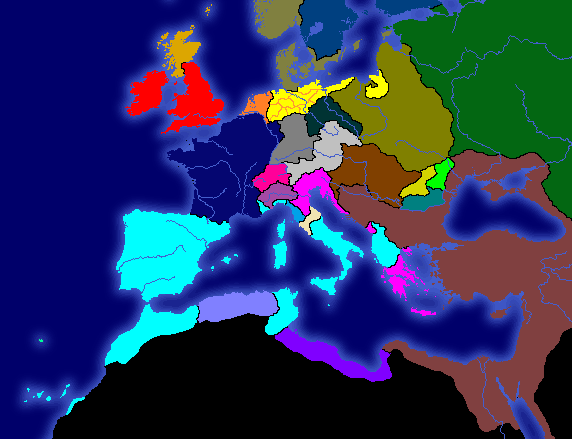
 
so all there is is bohemians and Moravians?

are there any actual Czechs in that country or is it under a different name?
 
so all there is is bohemians and Moravians?

are there any actual Czechs in that country or is it under a different name?

They are all Czech speakers who live in two historical regions.

It's a bit like English speakers who like Wessex and Sussex.
 
so all there is is bohemians and Moravians?

are there any actual Czechs in that country or is it under a different name?

Meh, it's complicated. See, in our language, it's like this:

Češi
(Czechs) means either A) citizens of the Czech Republic/people who speak Czech, or B) Bohemians, inhabitants of Bohemia. The terms Bohemia/Bohemians are of Germanic-Latin origin and we don't use them, except in the sense "bohemian" (bohém in Czech).

Moravané (Moravians) are people who live in Moravia.

Česká republika/Česko (Czech Republic/Czechia) are the formal/informal names of the country.


Some Moravians object to the name of the country, because in their view it only refers to a half of it, like if you called Belgium "Flanders". Now, due to the idiotic way national censuses handle nationality (národnost), you can write whatever you want there (including fun stuff like Klingon or something). Some people tend to write "Moravian", and as a result the Czech Republic is often cited to have a Moravian "minority". That is absurd, since Moravians basically make up a half of Czech Rep's population. It's a regional identity, not ethnic or national division.
 
So, here we go again, with my general "AAARGH NONONO CIV'ED NOT ANOTHER ONE OF THOSE...." maps. :p
In this timeline, we have arrived at a wholly different 1900, the dawn of this timeline's World War. (there will never be a second one because Hitler's dad never met his mother. And anyway, probably, after this one no one will be bothered to do stuff again.)
So what we see here, 1/1/1900:
Spoiler :
2xyU8.png

The countries visible are Russia, Benelux (the orange thingy up there), France, Italy, the United Kingdom, Romanya (the eastern secessionists of the Ottomans), Bosna (the western secessionists of the Ottomans), The Ottomans (well DUH), the North German Federation, The South Germany Federation, the Rhineländer confederacy, Scandinavia, the Tripolitanian Council AKA Libya (the southern secessionists), Nejd-Oman, Portugal, Spain and Persiya-Gruziya, a kingdom that seceded from Russia.

These went to war with these "teams" (a bit like in our WWI). It all started with the wars of Revolution against the Ottomans (which, as you can see, have been more succesful than IOTL (that is the Ottomans, not the Secessionists))
Spoiler :
Qt4m7.png

Wherein blue is the Secessionist side, red the Ottoman side and grey neutral (on account of fighting each other)

And two years later we have this:
Spoiler :
HcCUL.png

If there is a color bordering another without actually having a border it's occupied territory.
As we can see, Bosna is not so successful, while various countries have gotten to a stalemate. Italy and Spain are slowly losing. Tripoli is slowly assaulting colonial possessions, who knows, they might hold it. Meanwhile the Glorious revolution is happening all over again.


And this is where I leave off. I invite you guys to continue this timeline IF YOU WANT.

Other than the fact that you gave basically no information on your TL, my biggest complaint is that the borders are painful to look at.
 
Spanish Domination: Part 2!

It's now 1648. Spain conquers Portugal and forms Iberia, then takes over Morocco, Tunis, and Albania. Lastly, Iberia takes a bite out of Venice. Meanwhile, Russia begins to sink it's teeth into Poland-Lithuania, The HRE loses all of it's land in Italy, West Germany is formed, the SGF takes Hesse (Or whatever is in Central Germany), France and The Netherlands lose some land, Hungary attacks Transylvania, Austria takes down Bohemia, Prussia takes Brandenburg, and Venice conquers Modena.

meddom0.png


Just for fun. Help me finish the map! Draw administrative borders, vassals, states, territories, provinces, prefectures so on and give them funny Colosseum names that relate to our forum.

The reason why I gave the above 6 their own kingdoms within Offtopica is because they are the biggest posters.
 
Gorazde! This map solved my problem from 20 years ago. Apparently there are two cities of that name, one in Bosnia and other in Poland. I was very much confused about it once.
 
Although I can tell from the notes, it would be nice if you could name which color is which country.

BTW, I misread that as "The Continent of Communism" at first, which made several of the countries on it all the funnier. :lol:
 
Yea, I've seen better for CivIII.
 
Bristol where Cardiff is? That's just disrespectful to the Welsh. :)
 
Status
Not open for further replies.
Back
Top Bottom