Snerk
Smeghead
I see northern Macedonia, middle Macedonia and southern Macedonia. But where is Greece? 
I see northern Macedonia, middle Macedonia and southern Macedonia. But where is Greece?
")
This is not correct. Prussia and Eastern Pomerania were not parts of the HRE.
And a question for Kyriakos. Why is this tiny island south to Peloponese part of the Attica region?
The map of London indicated that most of the Muslim minorities live north of Thames, most of the non-Muslim minorities live south of it. The French and the Lithuanians are north of course, but at the very south and east. Punjabis are south, but on the verge too. And there are some Hindu, Sikh etc Punjabis.
The map post-1204 is wrong. Venice never managed to occupy Rhodes.
Early in 1224, Emperor Frederick II announced at Catania that Livonia, Prussia with Sambia, and a number of neighbouring provinces were under Imperial immediacy (German: Reichsfreiheit). This decree subordinated the provinces directly to the Roman Catholic Church and the Holy Roman Emperor as opposed to being under the jurisdiction of local rulers.
I know well about the Teutonic Knights. But they weren't part of the HRE as far as I know. And even if this information is true, that would mean the map is wrong in two cases. First, Eastern Pomerania (a.k.a. West Prussia) wasn't part of the Teutonic Knights at that time. And in fact, as of 1224, not a piece of Prussia part of Teutonic Knights too. They came to Kulmland, part of Mazovia, at the invitation of its ruler Konrad the Mazovian shortly afterwards. So the emperor could the same claim Egypt as his own, but well, it wasn't under his rule. On another hand, a separate (later united) monastic order that conquered Livonia started out a bit earlier. Still, I have never heard it was included in HRE. And it is not part of HRE in this map too.
I'm surprised Ben Shapiro hasn't used that image unironically since it combines his two favorite things: questionable supplements marketed to stupid men and Israeli ultranationalism.
I'm surprised Ben Shapiro hasn't used that image unironically since it combines his two favorite things: questionable supplements marketed to stupid men and Israeli ultranationalism.
Since when do you read DuffelBlog, @Kyriakos?
I first saw it at TWC years ago.Yeah, I know. I read the American military-themed comedy blog that served as its original source.As Lexicus said, it is an old pic
Independence stuff.
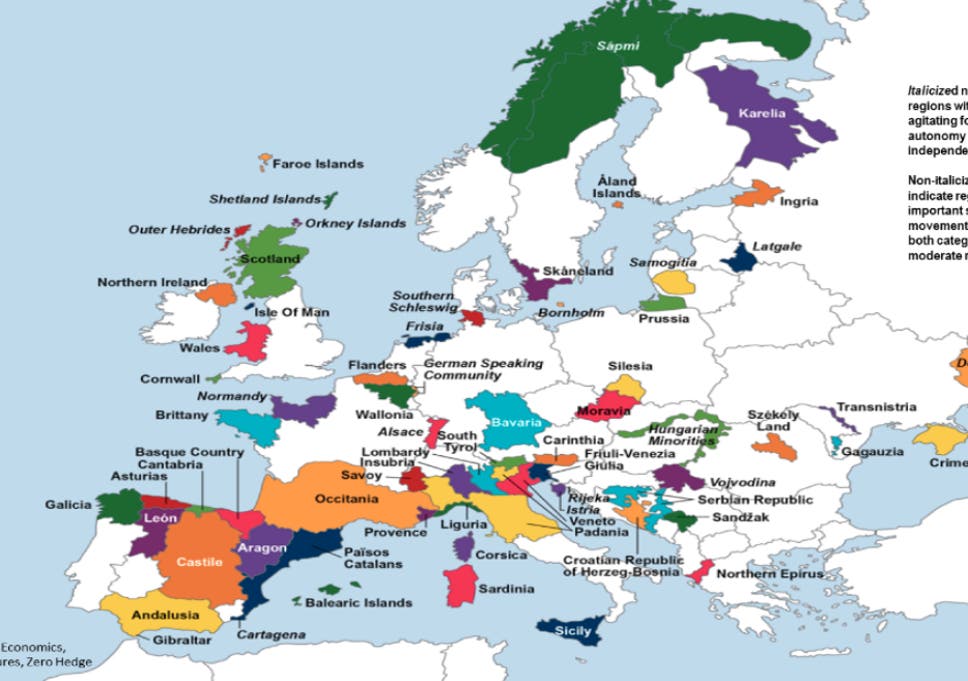
Belgium

